
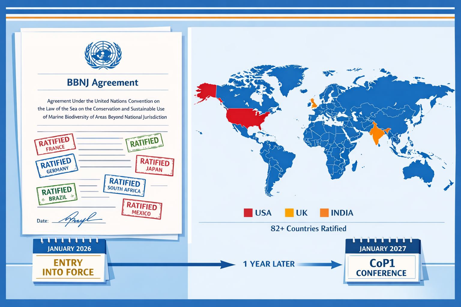
The world's oceans entered a new era of protection on January 17, 2026, when the historic High Seas Treaty officially came into force. This landmark agreement, formally known as the Biodiversity Beyond National Jurisdiction (BBNJ) Agreement, now governs nearly two-thirds of the ocean that lies beyond any country's control. For marine ecologists and biodiversity surveyors, this milestone creates an immediate need to understand and implement compliant survey protocols that meet the Treaty's rigorous environmental standards. The High Seas Treaty Implementation: Post-January 2026 Marine Biodiversity Survey Protocols for Ecologists represents a fundamental shift in how scientists conduct baseline assessments, environmental impact studies, and biodiversity net gain evaluations in international waters.
With 82 countries having ratified the agreement as of mid-January 2026, the Treaty establishes binding obligations for environmental impact assessments, marine protected area designations, and technology sharing that directly affect field research methodologies.[2] Ecologists working in high seas environments must now navigate new compliance requirements while maintaining scientific rigor in their biodiversity surveys.
Key Takeaways
- 🌊 The High Seas Treaty entered into force January 17, 2026, creating mandatory environmental assessment protocols for all activities in international waters affecting marine biodiversity
- 📋 Ecologists must now follow standardized survey methodologies that align with Treaty requirements for baseline biodiversity assessments and impact evaluations
- 🗓️ The first Conference of Parties (CoP1) must convene by January 17, 2027, establishing governance procedures and identifying priority marine protected areas
- 🔬 Countries are required to cooperate on marine science and technology sharing, creating new opportunities for collaborative biodiversity research
- 📊 Survey protocols must now incorporate robust environmental standards and public notification processes for any planned high seas activities
Understanding the High Seas Treaty Framework and Its Impact on Marine Research
What the Treaty Covers
The High Seas Treaty addresses biodiversity conservation and sustainable use in areas beyond national jurisdiction (ABNJ), commonly called the high seas. These waters cover approximately 43% of Earth's surface and contain some of the planet's most critical yet vulnerable ecosystems.[3] The Treaty establishes four main pillars that directly impact ecological survey work:
- Marine Protected Areas (MPAs) – Designation and management of conservation zones
- Environmental Impact Assessments (EIAs) – Mandatory evaluation processes for planned activities
- Marine Genetic Resources – Governance of biological samples and benefit-sharing
- Capacity Building and Technology Transfer – Scientific cooperation and resource sharing
For biodiversity surveyors, the environmental impact assessment requirements create the most immediate operational changes. Any planned activity under a Party's control that could affect the high seas or seabed must now follow the Treaty's environmental impact assessment processes, and governments must publicly notify such activities.[2]
Current Ratification Status and Geographic Scope
As of January 2026, 82 countries had ratified the agreement, with more ratifications expected throughout the year.[2] However, notable gaps remain among major maritime nations. The United States has signed but not ratified the Treaty, India has adopted it but awaits domestic legislation, and the United Kingdom has introduced legislation but not yet completed ratification.[4]
This patchwork ratification creates practical challenges for ecologists conducting surveys across different jurisdictions. Understanding which countries have ratified the Treaty helps determine applicable protocols for research vessels, funding sources, and data-sharing arrangements.
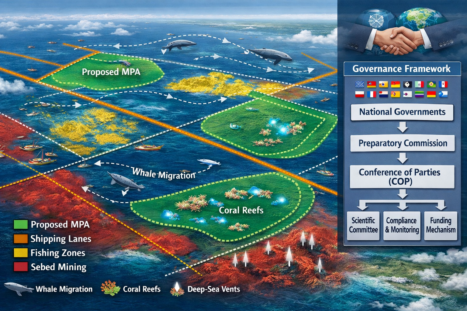
The Preparatory Commission and Institutional Architecture
The Preparatory Commission is currently shaping the Treaty's institutional architecture, including the bodies and decision-making processes that will govern implementation.[2] This commission works to develop proposals for adoption at the first Conference of Parties (CoP1), which must convene within one year of entry into force—by January 17, 2027.[3]
For ecologists planning multi-year survey projects, this transitional period presents both challenges and opportunities. While some procedural details remain under development, the core environmental assessment requirements are already binding on ratifying nations. Similar to how biodiversity surveyors benefit both nature and developers in terrestrial contexts, marine ecologists must now balance conservation objectives with scientific research needs.
High Seas Treaty Implementation: Post-January 2026 Marine Biodiversity Survey Protocols for Ecologists – Core Requirements
Environmental Impact Assessment Protocols
The Treaty mandates comprehensive environmental impact assessments for any activity that could affect high seas biodiversity. For ecologists, this means developing survey protocols that document baseline conditions before research activities begin and monitoring potential impacts throughout project duration.
Key EIA Components for Marine Surveys:
| Assessment Element | Survey Protocol Requirement | Documentation Standard |
|---|---|---|
| Baseline Biodiversity | Species inventories, abundance estimates, habitat mapping | Peer-reviewed methodologies, GPS-referenced data |
| Impact Prediction | Modeling of survey equipment effects, vessel disturbance analysis | Quantitative risk assessments, sensitivity analyses |
| Mitigation Measures | Seasonal timing, equipment modifications, exclusion zones | Detailed operational procedures, monitoring plans |
| Public Notification | Activity descriptions, location coordinates, timeline | Government portal submissions, stakeholder consultations |
| Monitoring & Reporting | Ongoing biodiversity tracking, incident documentation | Standardized data formats, regular progress reports |
These requirements mirror the comprehensive approach used in terrestrial biodiversity impact assessments, but adapted for the unique challenges of open ocean environments.
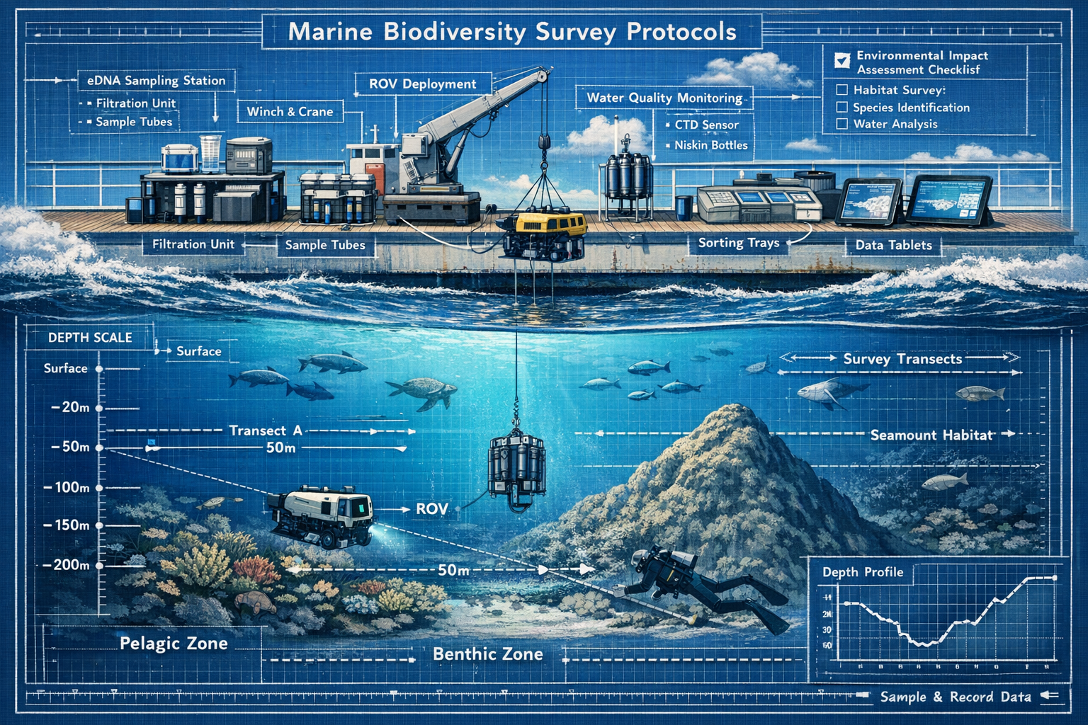
Standardized Survey Methodologies
To ensure consistency across international waters, ecologists should adopt standardized survey methodologies that align with emerging Treaty guidance. While CoP1 will establish formal protocols, current best practices include:
Water Column Surveys:
- Environmental DNA (eDNA) sampling at standardized depths
- Plankton net tows following established transect patterns
- Acoustic monitoring for marine mammals and fish populations
- CTD (Conductivity, Temperature, Depth) profiling for habitat characterization
Benthic Surveys:
- Remotely Operated Vehicle (ROV) video transects with georeferencing
- Sediment core sampling for infaunal communities
- Multibeam sonar mapping for habitat structure
- Photographic quadrat sampling at representative sites
Pelagic Surveys:
- Visual observation protocols for megafauna
- Satellite tagging studies for migration patterns
- Biopsy sampling following non-invasive guidelines
- Hydroacoustic surveys for biomass estimation
Data Management and Sharing Requirements
Countries must cooperate on marine science and technology sharing under the Treaty's capacity-building provisions.[3] This creates new obligations for data management that extend beyond traditional research practices.
Essential Data Management Protocols:
✅ Standardized formats – Use internationally recognized data schemas (Darwin Core, OBIS formats)
✅ Metadata completeness – Document survey methods, equipment specifications, quality control procedures
✅ Timely submission – Share baseline data with relevant national authorities and international databases
✅ Open access principles – Make non-sensitive biodiversity data publicly available through approved repositories
✅ Chain of custody – Maintain clear documentation for genetic resource samples and associated data
This collaborative approach reflects the same principles that guide biodiversity net gain planning in terrestrial contexts, where transparency and standardization ensure credible outcomes.
Integration with Existing International Bodies
Parties must promote the Treaty's objectives when participating in other bodies such as those governing shipping, fisheries, and seabed mining.[2] For ecologists, this means coordinating survey protocols with:
- International Seabed Authority (ISA) – For surveys near mineral exploration areas
- Regional Fisheries Management Organizations (RFMOs) – For assessments in commercial fishing zones
- International Maritime Organization (IMO) – For shipping route considerations
- Convention on Biological Diversity (CBD) – For alignment with Aichi Targets and post-2020 framework
Understanding these institutional relationships helps ecologists design surveys that fulfill multiple regulatory requirements simultaneously, improving efficiency and reducing redundant data collection.
Practical Implementation Guidelines for Marine Biodiversity Surveys in 2026
Pre-Survey Planning and Compliance Verification
Before initiating any high seas biodiversity survey in 2026, ecologists must complete several compliance steps that differ significantly from pre-Treaty procedures.
Step 1: Jurisdiction Verification
Confirm whether the survey area falls within the Treaty's scope (areas beyond national jurisdiction) and verify the ratification status of the flag state for research vessels. This determines which specific protocols apply.
Step 2: Activity Notification
Submit detailed activity notifications to relevant national authorities, including survey objectives, methodologies, equipment specifications, timeline, and potential environmental impacts. Governments must publicly notify planned activities affecting the high seas.[2]
Step 3: Baseline Assessment Design
Develop comprehensive baseline survey protocols that document pre-existing biodiversity conditions. This establishes the reference point for evaluating any impacts from survey activities themselves or from other human activities in the area.
Step 4: Stakeholder Consultation
Engage with other high seas users, including fishing operations, shipping interests, and conservation organizations. The Treaty emphasizes collaborative governance and multi-stakeholder participation in decision-making.
Step 5: Mitigation Planning
Identify potential survey impacts and develop specific mitigation measures, such as seasonal timing to avoid breeding periods, equipment modifications to reduce noise pollution, or spatial buffers around sensitive habitats.
Field Survey Execution Standards
During active survey operations, maintaining compliance requires attention to operational details that extend beyond traditional scientific protocols.
Equipment and Methodology Standards:
🔧 Non-invasive techniques – Prioritize observation and remote sensing methods over extractive sampling when possible
🔧 Calibrated instruments – Ensure all measurement devices meet international calibration standards and maintain calibration logs
🔧 Minimal disturbance – Implement vessel speed restrictions, noise reduction measures, and waste management protocols
🔧 Real-time monitoring – Track survey impacts through concurrent environmental monitoring and adjust operations as needed
🔧 Incident documentation – Record any unintended interactions with marine life, equipment malfunctions, or deviations from approved protocols
Identifying Sites for Marine Protected Area Proposals
Countries are encouraged to begin identifying important high seas sites that require protection for proposals at future meetings.[2] Biodiversity surveyors play a crucial role in this identification process by conducting surveys that reveal conservation priorities.
Criteria for MPA Candidate Identification:
- Ecological significance – Unique habitats, endemic species, or biodiversity hotspots
- Vulnerability – Areas threatened by climate change, pollution, or extractive activities
- Representativeness – Ecosystems typical of broader high seas environments
- Connectivity – Migration corridors, larval dispersal pathways, or genetic exchange routes
- Feasibility – Practical considerations for monitoring, enforcement, and management
Survey data supporting MPA proposals should include quantitative biodiversity metrics, habitat mapping, threat assessments, and management recommendations. This evidence-based approach mirrors the systematic methodology used in biodiversity net gain assessments for terrestrial development projects.
Post-Survey Reporting and Data Submission
The Treaty's transparency requirements extend to post-survey reporting obligations that ensure accountability and knowledge sharing.
Required Reporting Elements:
📊 Survey summary – Overview of activities conducted, areas covered, and timeline
📊 Biodiversity findings – Species lists, abundance estimates, habitat descriptions, and notable observations
📊 Impact assessment – Evaluation of actual survey impacts compared to predicted effects
📊 Mitigation effectiveness – Analysis of whether mitigation measures achieved intended outcomes
📊 Recommendations – Suggestions for future surveys, conservation priorities, or management actions
📊 Raw data submission – Deposit of complete datasets in approved international repositories
Reports should be submitted to national authorities, shared with relevant international bodies, and made publicly accessible through appropriate channels. This level of transparency supports the Treaty's objective of building collective understanding of high seas biodiversity.
Capacity Building and Technology Transfer Opportunities
The Treaty's provisions for marine science and technology sharing create opportunities for ecologists to access advanced survey technologies and collaborate with international partners.[3] This is particularly valuable for researchers from developing nations or institutions with limited resources.
Available Support Mechanisms:
- Equipment sharing programs for specialized survey instruments
- Training workshops on standardized survey methodologies
- Collaborative research expeditions with international teams
- Data analysis support through partner institutions
- Funding opportunities for high seas biodiversity research
Ecologists should actively engage with the Preparatory Commission's capacity-building initiatives and participate in knowledge-sharing networks. Just as biodiversity surveyors help developers navigate complex regulations, experienced marine ecologists can support colleagues in adopting Treaty-compliant protocols.
Preparing for CoP1 and Future Protocol Development
Timeline and Expected Outcomes
The first Conference of Parties (CoP1) must convene by January 17, 2027, exactly one year after the Treaty entered into force.[3] This meeting will establish critical governance procedures and make initial decisions about marine protected area locations.
Expected CoP1 Decisions:
- Governance structure – Formal establishment of Treaty bodies, decision-making procedures, and voting rules
- Financial mechanisms – Funding arrangements for Treaty implementation and capacity building
- Scientific advisory processes – Procedures for incorporating scientific evidence into policy decisions
- MPA designation criteria – Formal standards for identifying, proposing, and establishing protected areas
- EIA guidelines – Detailed protocols for conducting and reviewing environmental impact assessments
- Technology transfer frameworks – Specific mechanisms for sharing marine research capabilities
Ecologists conducting surveys in 2026 should design their work to generate data relevant to these upcoming decisions. For example, baseline biodiversity assessments in potential MPA sites will directly inform CoP1 discussions about conservation priorities.
Evolving Protocol Standards
While current survey protocols follow best available practices, formal standards will continue to evolve as the Treaty's institutional architecture develops. Ecologists should anticipate several areas of protocol refinement:
Likely Protocol Developments:
- Standardized taxonomic references – Agreement on authoritative species lists and naming conventions
- Minimum survey effort requirements – Specifications for sampling intensity, duration, and spatial coverage
- Quality assurance procedures – Standards for data validation, peer review, and accuracy verification
- Genetic resource protocols – Detailed procedures for sample collection, storage, and benefit-sharing
- Cumulative impact assessment – Methods for evaluating combined effects of multiple activities
Staying informed about these developments requires engagement with official Treaty communications, participation in scientific working groups, and monitoring of Preparatory Commission outputs.
Building Survey Programs with Adaptive Capacity
Given the evolving nature of Treaty implementation, ecologists should design survey programs with adaptive capacity that allows protocol adjustments as formal standards emerge.
Adaptive Survey Design Principles:
✓ Modular methodologies – Use survey components that can be modified independently without compromising overall program integrity
✓ Comprehensive documentation – Maintain detailed records that allow retrospective analysis under new standards
✓ Flexible data formats – Collect data in formats that can be converted to emerging international standards
✓ Collaborative partnerships – Build relationships with institutions that can provide guidance on protocol updates
✓ Regular protocol reviews – Schedule periodic assessments of survey methods against current Treaty guidance
This adaptive approach ensures that survey investments remain valuable even as regulatory requirements evolve. Similar flexibility is essential in terrestrial biodiversity net gain projects, where regulatory frameworks continue to develop.
Challenges and Solutions for High Seas Treaty Implementation
Technical Challenges in Open Ocean Surveys
Conducting biodiversity surveys in high seas environments presents unique technical challenges that Treaty compliance requirements may intensify.
Common Technical Obstacles:
- Access limitations – High costs and logistical complexity of reaching remote ocean areas
- Weather dependency – Survey operations constrained by sea conditions and seasonal windows
- Equipment requirements – Need for specialized, expensive instruments for deep-sea work
- Sample preservation – Maintaining specimen integrity during extended expeditions
- Data transmission – Limited connectivity for real-time data submission from remote locations
Practical Solutions:
💡 Collaborative expeditions – Share vessel costs and resources through multi-institution partnerships
💡 Autonomous systems – Deploy gliders, floats, and autonomous underwater vehicles for continuous monitoring
💡 Strategic timing – Coordinate survey schedules with optimal weather windows and biological activity periods
💡 Onboard processing – Invest in shipboard laboratory capabilities for immediate sample analysis
💡 Satellite communications – Utilize improved connectivity options for data transmission and remote consultation
Regulatory Complexity and Compliance Navigation
The intersection of the High Seas Treaty with existing maritime regulations creates a complex compliance landscape that can be difficult to navigate.
Regulatory Coordination Strategies:
- Develop comprehensive compliance checklists covering all applicable regulations
- Consult with maritime lawyers specializing in international ocean law
- Engage early with national authorities to clarify requirements
- Participate in industry working groups addressing regulatory harmonization
- Maintain relationships with regulatory agencies for ongoing guidance
Understanding how different regulatory frameworks interact is similar to navigating multiple biodiversity requirements in development projects, where various environmental laws must be satisfied simultaneously.
Funding and Resource Constraints
High seas biodiversity surveys require substantial financial resources, and Treaty compliance may add costs without corresponding funding increases.
Resource Optimization Approaches:
- Pursue Treaty-specific funding through capacity-building mechanisms
- Leverage citizen science and volunteer programs for data collection
- Utilize existing survey platforms (fishing vessels, cargo ships) as observation platforms
- Apply for international research grants emphasizing Treaty implementation
- Develop partnerships with conservation organizations seeking baseline data
The Role of Biodiversity Surveyors in Treaty Success
Professional Opportunities and Responsibilities
The High Seas Treaty creates significant professional opportunities for qualified biodiversity surveyors while establishing new responsibilities for the ecological community.
Emerging Career Paths:
- Treaty compliance specialists for marine research institutions
- Environmental impact assessment consultants for high seas activities
- Marine protected area monitoring coordinators
- International data management specialists
- Capacity-building trainers for developing nations
These opportunities parallel the expanding roles for biodiversity surveyors in terrestrial contexts, where regulatory frameworks create demand for specialized expertise.
Contributing to Global Ocean Governance
Ecologists conducting high seas surveys contribute directly to global ocean governance by generating the scientific evidence that informs policy decisions. This responsibility extends beyond traditional research objectives to include:
- Policy-relevant data collection – Designing surveys that address specific management questions
- Stakeholder communication – Translating scientific findings for policymakers and public audiences
- Adaptive management support – Providing feedback on protocol effectiveness and suggesting improvements
- International collaboration – Building scientific networks that transcend national boundaries
Ethical Considerations in Marine Biodiversity Research
The Treaty's emphasis on benefit-sharing and equitable access raises important ethical considerations for biodiversity surveyors working in international waters.
Key Ethical Principles:
🌍 Equitable partnerships – Ensure developing nations participate meaningfully in research planning and execution
🌍 Benefit distribution – Share research outcomes, capacity building, and economic benefits fairly
🌍 Traditional knowledge respect – Acknowledge and incorporate indigenous and local knowledge where relevant
🌍 Conservation priorities – Balance scientific objectives with conservation needs and precautionary approaches
🌍 Transparency – Maintain open communication about research purposes, methods, and findings
These ethical considerations align with broader trends toward sustainable and responsible biodiversity management that recognize multiple stakeholder interests.
Conclusion
The entry into force of the High Seas Treaty in January 2026 marks a transformative moment for marine biodiversity conservation and the ecologists who study it. The High Seas Treaty Implementation: Post-January 2026 Marine Biodiversity Survey Protocols for Ecologists represents more than just regulatory compliance—it embodies a fundamental shift toward collaborative, transparent, and scientifically rigorous ocean governance.
For biodiversity surveyors, the immediate priorities are clear: understand the Treaty's requirements, adopt standardized survey methodologies, engage with the evolving institutional architecture, and prepare for the critical decisions that will be made at CoP1 in 2027. While challenges exist in terms of technical complexity, regulatory coordination, and resource constraints, the Treaty also creates unprecedented opportunities for international collaboration, capacity building, and meaningful contribution to global conservation efforts.
The success of the High Seas Treaty depends directly on the quality of biodiversity data that ecologists generate in the coming years. Baseline assessments conducted now will inform marine protected area designations, environmental impact evaluations, and adaptive management strategies for decades to come. By embracing Treaty-compliant protocols and participating actively in the governance process, biodiversity surveyors can ensure that the best available science guides decisions about the largest ecosystem on Earth.
Actionable Next Steps
For ecologists planning high seas surveys in 2026 and beyond:
- Review the full Treaty text and familiarize yourself with all provisions affecting marine research
- Establish relationships with national authorities responsible for Treaty implementation in your jurisdiction
- Join professional networks focused on high seas biodiversity research and Treaty implementation
- Invest in standardized survey equipment and methodologies that align with emerging protocols
- Develop data management systems capable of meeting international sharing requirements
- Participate in Preparatory Commission consultations and contribute to protocol development
- Build collaborative partnerships that enhance survey capacity and ensure compliance
- Monitor CoP1 preparations and plan research programs that address identified priorities
The High Seas Treaty represents humanity's commitment to protecting the ocean's biodiversity for future generations. As the scientists responsible for documenting and monitoring that biodiversity, ecologists carry both the privilege and responsibility of making this commitment a reality. The protocols established in 2026 will set the standard for decades of marine conservation work—making this a pivotal moment for the profession and the planet.
For those seeking to understand how similar biodiversity assessment principles apply in other contexts, exploring resources on biodiversity net gain implementation and comprehensive biodiversity planning provides valuable parallels that can inform marine survey approaches.
References
[1] High Seas Treaty Entry Into Force – https://www.pgaction.org/news/high-seas-treaty-entry-into-force.html
[2] Historic High Seas Treaty Enters Into Force Launching A New Era Of Global Ocean Governance – https://highseasalliance.org/2026/01/16/historic-high-seas-treaty-enters-into-force-launching-a-new-era-of-global-ocean-governance/
[3] High Seas Treaty Enters Into Force Historic Leap Ocean Protection – https://www.ifaw.org/press-releases/high-seas-treaty-enters-into-force-historic-leap-ocean-protection
[4] news.un – https://news.un.org/en/story/2026/01/1166762
[5] High Seas Treaty Ratification – https://www.nature.org/en-us/what-we-do/our-insights/perspectives/high-seas-treaty-ratification/
[6] Historic High Seas Treaty Enters Into Force Launching A New Era Of Global Ocean Governance – https://aida-americas.org/en/press/historic-high-seas-treaty-enters-into-force-launching-a-new-era-of-global-ocean-governance
[7] With 60 Ratifications Bbnj Agreement To Enter Into Force In January 2026 – https://sdg.iisd.org/news/with-60-ratifications-bbnj-agreement-to-enter-into-force-in-january-2026/
[8] High Seas Treaty Takes Effect But Key Rules Remain Unresolved – https://www.courthousenews.com/high-seas-treaty-takes-effect-but-key-rules-remain-unresolved/
