
"
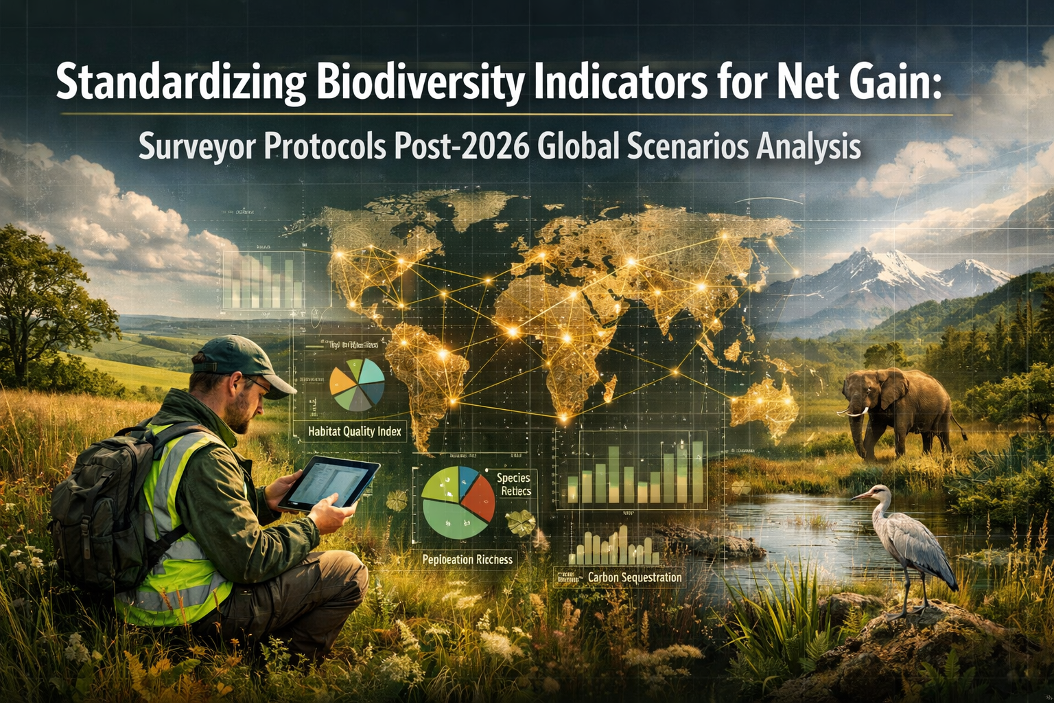
The race to reverse biodiversity loss has entered a critical phase. As development projects worldwide grapple with increasingly stringent environmental requirements, ecologists and surveyors face a pressing challenge: how can we ensure biodiversity measurements are truly comparable across projects, regions, and nations? Recent meta-analyses reveal significant gaps in our approach to bending the biodiversity loss curve, pointing to an urgent need for Standardizing Biodiversity Indicators for Net Gain: Surveyor Protocols Post-2026 Global Scenarios Analysis.
In 2026, as biodiversity net gain (BNG) requirements expand globally and nationally significant infrastructure projects in the UK come under mandatory regulations, the ecological surveying profession stands at a crossroads. The decisions made today about measurement protocols, indicator selection, and data standardization will shape environmental outcomes for decades to come.
Key Takeaways
- 🌍 Global standardization of biodiversity indicators is essential for comparable BNG reporting across jurisdictions, with the UK's Biodiversity Metric 4.0 serving as a foundational model
- 📊 Post-2026 surveyor protocols must address critical gaps in habitat condition assessment, temporal monitoring, and cross-border ecological connectivity measurements
- ✅ Practical checklists and quality assurance frameworks enable ecologists to deliver consistent, defensible biodiversity assessments regardless of project scale or location
- 🔄 Harmonized reporting standards facilitate biodiversity unit trading, off-site compensation verification, and cumulative impact analysis across development portfolios
- 🚀 Technology integration through standardized digital tools, remote sensing protocols, and centralized databases will transform surveyor efficiency and data reliability
Understanding the Current Landscape of Biodiversity Net Gain
The UK Framework and Its Global Influence
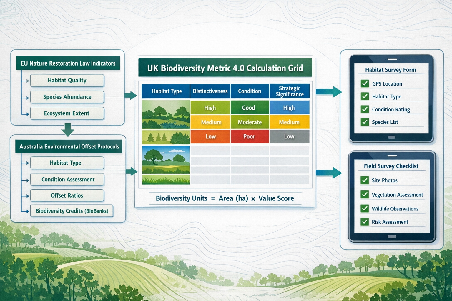
The United Kingdom has emerged as a pioneer in mandatory biodiversity net gain legislation. Under the Environment Act 2021, developments in England must demonstrate a minimum 10% biodiversity net gain [1]. This requirement became mandatory for major developments in February 2024, with nationally significant infrastructure projects scheduled to comply by May 2026 [8].
The UK's approach centers on the Biodiversity Metric, a standardized calculation tool that quantifies habitat value based on:
- Habitat distinctiveness (from very low to very high)
- Habitat condition (poor, moderate, or good)
- Strategic significance (location-specific ecological importance)
- Temporal factors (time to target condition and difficulty of creation)
This metric generates biodiversity units that enable developers to calculate baseline habitat value, post-development value, and the net change requiring compensation [3]. The framework has influenced biodiversity net gain assessment methodologies internationally.
Research Gaps in Global Biodiversity Measurement
Despite the UK's progress, recent meta-analyses have identified critical gaps in global efforts to reverse biodiversity decline:
Inconsistent indicator selection across jurisdictions makes cross-border projects challenging to assess comparably. While the UK focuses on habitat-based metrics, other nations prioritize species counts, ecosystem services, or functional diversity measures.
Temporal monitoring protocols vary dramatically, with some frameworks requiring 30-year monitoring commitments while others accept 5-year verification periods. This inconsistency undermines long-term biodiversity outcome predictions.
Data quality standards differ substantially between surveyor qualifications, field methodology rigor, and verification requirements. Without standardized protocols, biodiversity net gain reports from different consultancies may not be directly comparable.
Standardizing Biodiversity Indicators for Net Gain: Core Principles for Surveyor Protocols
Essential Components of Standardized Indicators
Effective standardization requires agreement on fundamental measurement principles. The following framework synthesizes best practices from UK implementation and international biodiversity assessment standards:
| Indicator Category | Standardization Requirements | Surveyor Protocol Elements |
|---|---|---|
| Habitat Classification | Unified typology system with clear definitions | Field identification keys, photographic references, decision trees |
| Condition Assessment | Objective, measurable criteria for each habitat type | Standardized survey forms, quantitative thresholds, quality indicators |
| Spatial Mapping | Consistent GIS protocols and minimum mapping units | GPS accuracy standards, boundary delineation rules, layer specifications |
| Species Recording | Taxonomic standardization and survey effort metrics | Season-specific protocols, minimum survey visits, competency requirements |
| Temporal Monitoring | Harmonized timeframes and measurement intervals | Baseline-to-target timelines, monitoring frequency schedules, reporting milestones |
The Biodiversity Metric as a Standardization Model
Natural England's Biodiversity Metric represents the most comprehensive attempt at standardization to date [3]. Key features that support comparable reporting include:
Habitat Distinctiveness Scores: A six-point scale (0-8) assigns ecological value based on habitat rarity, species richness, and ecosystem function. This removes subjective judgment from baseline assessments.
Condition Assessment Criteria: Each broad habitat type has specific, measurable condition criteria. For example, grassland condition depends on indicator species presence, sward structure, and management evidence—not surveyor opinion [2].
Strategic Significance Multipliers: Location-based factors (proximity to designated sites, ecological networks, priority habitats) apply consistent spatial weighting across all assessments.
Trading Rules: Standardized rules govern when habitats can be substituted, preventing "trading down" from high-value to low-value habitats regardless of biodiversity unit equivalence [6].
For planners navigating biodiversity net gain requirements, these standardized elements provide confidence that assessments are defensible and comparable.
Addressing International Variations
While the UK metric provides a strong foundation, global standardization must accommodate legitimate regional variations:
🌏 Climate Zone Adaptations: Tropical, temperate, and arid ecosystems require different habitat classifications and condition indicators. Standardization should focus on methodological consistency rather than identical habitat lists.
🏛️ Regulatory Context Integration: Different jurisdictions have varying legal frameworks, planning systems, and environmental priorities. Standardized protocols must remain flexible enough to satisfy local regulatory requirements while maintaining core comparability.
🔬 Scientific Knowledge Gaps: Biodiversity understanding varies globally. Standardized protocols should include tiered approaches—basic methods for data-poor regions and advanced techniques where ecological knowledge permits detailed assessment.
Standardizing Biodiversity Indicators for Net Gain: Practical Surveyor Checklists for Post-2026 Scenarios
Pre-Survey Planning and Scoping Checklist
Standardized biodiversity assessments begin with thorough preparation. This checklist ensures surveyors gather comparable baseline data:
Desktop Study Requirements:
- ✅ Review all designated sites within 2km radius (international equivalent of SSSIs, SACs, SPAs)
- ✅ Obtain habitat mapping from national databases (equivalent to MAGIC, NBN Atlas)
- ✅ Compile protected species records from previous 10 years
- ✅ Identify ecological connectivity corridors and strategic networks
- ✅ Determine applicable biodiversity metric version and jurisdiction-specific modifications
- ✅ Establish baseline reference date for temporal calculations
Survey Scope Definition:
- ✅ Define survey area boundaries using standardized spatial protocols
- ✅ Identify all habitat types requiring assessment using unified classification system
- ✅ Determine season-specific survey requirements for each habitat/species group
- ✅ Calculate minimum survey effort based on site area and habitat complexity
- ✅ Establish data quality standards and verification requirements
- ✅ Confirm surveyor competency levels match protocol requirements
This systematic approach ensures biodiversity impact assessments maintain consistency regardless of surveyor or geographic location.
Field Survey Protocol Standardization
Field methodology represents the greatest source of variation in biodiversity assessments. These standardized protocols address common inconsistencies:
Habitat Mapping Standards:
- Minimum Mapping Unit: 0.25 hectares for broad habitats; 0.01 hectares for priority habitats
- Boundary Precision: GPS accuracy ±5 meters; hand-drawn boundaries only when technology unavailable
- Mosaic Habitats: Record all components >10% coverage; identify dominant habitat for primary classification
- Linear Features: Minimum 20-meter length; record width to nearest meter
- Temporal Considerations: Photograph all habitat parcels with date-stamped imagery; record seasonal variation evidence
Condition Assessment Standardization:
- Quantitative Thresholds: Use measurable criteria (e.g., "≥7 indicator species per m²" not "diverse sward")
- Sampling Intensity: Minimum 3 condition assessment points per habitat parcel <2 hectares; additional point per hectare above 2 hectares
- Evidence Documentation: Photograph condition indicators; record GPS coordinates of assessment points
- Scoring Consistency: Apply condition criteria hierarchically—all criteria must be met for higher condition categories
- Quality Assurance: Second surveyor verification for habitats scoring "good" condition or distinctiveness ≥6
Species Survey Protocols:
- Survey Timing: Adhere to standardized seasonal windows for each taxonomic group
- Effort Metrics: Record person-hours, weather conditions, and survey methods for all visits
- Identification Standards: Photograph/voucher specimens for verification; use standardized nomenclature
- Incidental Records: Document all species observed, not only target groups
- Negative Data: Record survey effort even when target species absent (essential for absence confirmation)
Post-Survey Data Management and Reporting
Standardized data handling ensures comparability extends beyond field collection:
Data Entry Protocols:
- Use standardized digital templates with validation rules preventing entry errors
- Apply unified habitat codes from agreed classification system
- Record surveyor details, qualifications, and survey dates for all data points
- Include data quality flags (confirmed, probable, possible) for uncertain classifications
- Georeference all records using standardized coordinate systems
Calculation Standardization:
- Apply current version of agreed biodiversity metric without modifications
- Document all assumptions and professional judgments with justification
- Use standardized temporal multipliers based on habitat creation difficulty
- Apply trading rules consistently across all habitat exchanges
- Calculate both on-site and off-site requirements using harmonized approaches
Reporting Requirements:
- Follow standardized report structure enabling cross-project comparison
- Include mandatory data tables in specified formats
- Provide GIS layers in agreed formats with metadata
- Document deviations from standard protocols with justification
- Include quality assurance statement and peer review confirmation
For architects solving biodiversity net gain challenges, standardized reports enable confident design integration and regulatory compliance.
Global Scenarios Analysis: Post-2026 Standardization Pathways
Scenario 1: Harmonized International Framework
Probability: Moderate | Timeline: 2026-2030
This scenario envisions international cooperation producing a Global Biodiversity Measurement Standard analogous to carbon accounting protocols. Key developments include:
Institutional Framework: An international body (potentially under Convention on Biological Diversity) establishes core measurement principles, indicator selection criteria, and data exchange protocols.
Tiered Implementation: Countries adopt standardized frameworks at different sophistication levels:
- Tier 1: Basic habitat area and condition metrics for developing nations
- Tier 2: Intermediate species-inclusive assessments for emerging economies
- Tier 3: Advanced ecosystem function and connectivity metrics for developed nations
Technology Enablement: Standardized digital tools, including mobile apps with built-in validation, remote sensing protocols, and centralized databases, facilitate global data comparability.
Surveyor Implications: Professional ecologists require training in international standards; cross-border practice becomes feasible with recognized qualifications; biodiversity unit trading expands internationally.
Scenario 2: Regional Standardization Blocks
Probability: High | Timeline: 2026-2028
This more likely scenario sees regional cooperation producing compatible but distinct frameworks:
European Union: Expands Nature Restoration Law requirements with standardized biodiversity accounting across member states, building on existing Habitats Directive classifications.
Commonwealth Nations: UK-influenced jurisdictions (Australia, Canada, New Zealand) adopt modified versions of the Biodiversity Metric, creating Commonwealth-wide comparability.
North America: United States and Canada develop integrated frameworks aligning with existing conservation banking and wetland mitigation protocols.
Asia-Pacific: ASEAN nations collaborate on tropical ecosystem-specific metrics addressing unique biodiversity characteristics.
Surveyor Implications: Regional specialization emerges; surveyors working across regional boundaries require multi-framework competency; off-site biodiversity delivery operates within regional markets.
Scenario 3: Technology-Driven Convergence
Probability: Moderate-High | Timeline: 2027-2032
Rapid technological advancement drives de facto standardization through widely adopted platforms:
Remote Sensing Integration: Satellite imagery, drone surveys, and AI-powered habitat classification reduce reliance on ground surveys, creating inherent standardization through consistent technology application.
Blockchain Verification: Distributed ledger technology enables transparent biodiversity unit tracking, habitat condition monitoring, and offset verification across jurisdictions without formal international agreements.
Open-Source Platforms: Collaborative development of free, standardized assessment tools creates global user communities sharing protocols, validation datasets, and best practices.
Surveyor Implications: Traditional field skills remain essential but integrate with technology competencies; data science and remote sensing expertise become core surveyor qualifications; real-time monitoring replaces periodic assessments [4].
Preparing Surveyor Protocols for Multiple Scenarios
Given uncertainty about which pathway will dominate, prudent surveyor protocol development should:
Build on Proven Foundations: The UK Biodiversity Metric's habitat-based approach, condition assessment framework, and trading rules provide tested components applicable across scenarios.
Maintain Flexibility: Protocols should accommodate regional variations while preserving core comparability through modular design—standardized methodology with adaptable habitat classifications.
Embrace Technology: Digital tools, remote sensing, and automated validation should be integral to protocols from inception, not retrofitted additions.
Prioritize Data Quality: Regardless of standardization pathway, rigorous quality assurance, surveyor competency verification, and peer review remain essential for defensible assessments.
Enable Interoperability: Data formats, GIS standards, and reporting structures should facilitate cross-system compatibility even when full harmonization proves elusive.
Implementing Standardized Protocols: Challenges and Solutions
Surveyor Competency and Training
Challenge: Biodiversity assessment requires ecological expertise, but surveyor qualifications vary dramatically between jurisdictions and consultancies.
Solution: Develop tiered competency frameworks with:
- Foundation Level: Basic habitat identification and condition assessment for common habitat types
- Intermediate Level: Species survey competency, complex habitat assessment, metric calculations
- Advanced Level: Quality assurance, peer review, complex site assessment, protocol development
Professional bodies should establish standardized training programs, competency assessments, and continuing professional development requirements. The UK's Chartered Institute of Ecology and Environmental Management (CIEEM) provides a model for professional standardization [7].
Data Quality Assurance
Challenge: Even with standardized protocols, surveyor judgment introduces variability. Habitat boundaries, condition assessments, and species identification all involve interpretation.
Solution: Implement multi-layered quality assurance:
- Field Verification: Second surveyor spot-checks for percentage of sites
- Photo Documentation: Mandatory imagery for all habitat parcels and condition assessment points
- Peer Review: Independent technical review for projects above threshold values
- Statistical Validation: Analyze surveyor consistency through repeated measurements
- Accreditation Systems: Certify consultancies meeting quality standards, not just individual surveyors
Natural England's role in administering the UK BNG system includes quality oversight that could inform international approaches [3].
Temporal Monitoring and Long-Term Verification
Challenge: Biodiversity net gain requires decades-long monitoring to verify predicted outcomes. Standardized protocols must address surveyor changes, methodology evolution, and long-term data continuity.
Solution: Establish permanent monitoring frameworks:
- Baseline Documentation: Comprehensive site characterization with permanent markers, detailed photography, and archived specimens
- Standardized Monitoring Intervals: Year 1, 3, 5, 10, 20, 30 assessments using consistent methodology
- Data Archiving: Centralized repositories preserving baseline and monitoring data beyond individual project lifespans
- Methodology Versioning: Clear protocols for incorporating improved techniques while maintaining comparability with baseline assessments
- Financial Mechanisms: Monitoring bonds, trust funds, or insurance products ensuring long-term funding regardless of developer/landowner changes
Understanding why biodiversity net gain is important helps stakeholders appreciate the necessity of robust long-term monitoring.
Cross-Border and Transboundary Issues
Challenge: Ecological systems ignore political boundaries. Migratory species, watershed connectivity, and landscape-scale processes require assessment frameworks transcending jurisdictional limits.
Solution: Develop nested standardization:
- Core Global Standards: Universal principles for indicator selection, data quality, and calculation transparency
- Regional Adaptations: Climate zone, biogeographic realm, and ecosystem-specific modifications within global framework
- Bilateral Agreements: Neighboring jurisdictions establish compatible protocols for transboundary projects
- Cumulative Impact Assessment: Standardized approaches for evaluating multiple projects' combined effects across administrative boundaries
Technology Integration in Standardized Surveyor Protocols
Digital Field Data Collection
Modern standardized protocols must leverage technology to improve consistency and efficiency:
Mobile Applications: Purpose-built apps with:
- Pre-loaded habitat classification keys with photographic references
- GPS-enabled boundary mapping with automatic area calculation
- Standardized condition assessment forms with validation rules
- Offline functionality for remote locations with cloud synchronization
- Automatic metadata capture (surveyor, date, weather, location)
Quality Control Features: Built-in validation preventing common errors:
- Habitat combinations that shouldn't co-occur
- Condition scores inconsistent with recorded evidence
- Survey timing outside standardized seasonal windows
- GPS accuracy below threshold requirements
- Incomplete mandatory fields
Remote Sensing and Automated Classification
Post-2026 protocols should integrate remote sensing for:
Baseline Habitat Mapping: Satellite or drone imagery provides initial habitat classification, with ground-truthing validating and refining automated classifications. This ensures consistency in boundary delineation and reduces surveyor-to-surveyor variation.
Condition Monitoring: Temporal satellite data tracks vegetation health, structural complexity, and management indicators between ground surveys, providing early warning of degradation.
Verification: Independent remote sensing analysis validates surveyor assessments, identifying discrepancies requiring field investigation.
Limitations: Technology cannot replace ecological expertise for nuanced condition assessment, species identification, or complex habitat mosaics. Standardized protocols should specify appropriate technology applications and essential field verification requirements.
Centralized Data Platforms and Biodiversity Registries
Effective standardization requires infrastructure supporting data collection, verification, and accessibility:
National Biodiversity Registers: Centralized databases recording:
- All baseline assessments and biodiversity unit calculations
- Habitat creation, enhancement, and management commitments
- Monitoring data and outcome verification
- Offset site registrations and unit allocations
- Developer and landowner obligations
Data Standards: Unified formats enabling:
- Cross-project analysis and cumulative impact assessment
- Biodiversity unit marketplace transparency
- Research access for methodology improvement
- Public accountability and environmental outcome tracking
The UK's approach to biodiversity unit trading demonstrates the importance of transparent, centralized systems.
Future-Proofing Surveyor Protocols: Adaptive Management Approaches

Building in Protocol Evolution
Standardization must balance consistency with scientific advancement. Effective protocols include:
Version Control: Clear numbering and dating of protocol versions, with documentation of changes between versions and guidance for transitioning between versions for long-term monitoring projects.
Review Cycles: Scheduled protocol reviews (e.g., every 5 years) incorporating:
- Scientific advances in biodiversity measurement
- Practical implementation lessons from surveyor community
- Technology improvements and integration opportunities
- Regulatory evolution and policy alignment
Backwards Compatibility: Mechanisms enabling comparison between assessments using different protocol versions, such as conversion factors, parallel calculations, or retrospective baseline adjustments.
Incorporating Ecosystem Services and Natural Capital
Post-2026 protocols may expand beyond biodiversity to integrate:
Ecosystem Services Assessment: Standardized measurement of carbon sequestration, water quality regulation, flood mitigation, and pollination services alongside biodiversity indicators.
Natural Capital Accounting: Monetary valuation frameworks enabling cost-benefit analysis of biodiversity outcomes, though maintaining ecological metrics as primary decision criteria.
Multi-Benefit Optimization: Protocols identifying habitat interventions delivering maximum combined biodiversity, climate, and ecosystem service benefits.
Climate Change Adaptation
Standardized protocols must address climate-driven ecological change:
Dynamic Baselines: Recognition that "restoring" historical conditions may be inappropriate; protocols should enable forward-looking habitat targets aligned with projected climate conditions.
Resilience Indicators: Incorporating habitat connectivity, genetic diversity, and adaptive capacity into condition assessments and strategic significance calculations.
Temporal Uncertainty: Adjusting monitoring requirements and success criteria to account for climate-driven variability and non-linear ecosystem responses.
Conclusion: Charting the Path to Standardized Biodiversity Assessment
The standardization of biodiversity indicators for net gain represents one of the most significant challenges—and opportunities—facing ecological surveyors in 2026 and beyond. As development pressures intensify globally while biodiversity continues its alarming decline, the need for comparable, defensible, and scientifically robust assessment protocols has never been more urgent.
The UK's pioneering Biodiversity Metric demonstrates that standardization is achievable, providing a proven framework that balances ecological rigor with practical implementation. However, truly addressing the research gaps identified in recent meta-analyses requires expanding this approach internationally, developing surveyor protocols that maintain comparability across diverse ecosystems, regulatory contexts, and technological capabilities.
Key Actions for Ecological Surveyors
Immediate Steps (2026-2027):
- Adopt existing standardized frameworks like the UK Biodiversity Metric for all assessments, even where not legally required
- Implement comprehensive quality assurance processes including peer review and photo documentation
- Transition to digital field data collection tools with built-in validation
- Engage with professional bodies developing competency frameworks and training programs
- Contribute field experience to protocol refinement through consultation responses and practitioner forums
Medium-Term Development (2027-2030):
- Develop expertise in remote sensing and technology-integrated assessment approaches
- Build capacity for long-term monitoring and adaptive management
- Establish cross-jurisdictional professional networks sharing best practices
- Participate in pilot projects testing international standardization frameworks
- Advocate for centralized biodiversity registers and transparent data platforms
Long-Term Vision (Post-2030):
- Support emergence of globally harmonized biodiversity measurement standards
- Integrate ecosystem services and natural capital assessment with biodiversity protocols
- Embrace AI and automated classification while maintaining essential field verification
- Mentor next-generation surveyors in standardized methodology and ecological fundamentals
- Contribute to research addressing remaining knowledge gaps and protocol improvements
The Stakes for Biodiversity
Standardizing biodiversity indicators for net gain is not merely a technical exercise in measurement harmonization. It represents a fundamental shift in how humanity values and accounts for nature in development decisions. Without comparable, credible assessments, biodiversity net gain risks becoming a compliance exercise rather than a genuine mechanism for reversing ecological decline.
The surveyor protocols developed in 2026 and implemented in subsequent years will determine whether we successfully bend the biodiversity loss curve or continue the trajectory toward ecosystem collapse. Every habitat assessment, condition evaluation, and biodiversity unit calculation contributes to this collective outcome.
For developers, planners, and landowners seeking to navigate biodiversity net gain requirements, partnering with surveyors committed to standardized, quality-assured protocols ensures regulatory compliance while delivering genuine environmental benefits. Understanding biodiversity net gain fundamentals and working with qualified professionals makes the difference between projects that merely meet minimum requirements and those that contribute meaningfully to ecological restoration.
The path to standardized biodiversity assessment is challenging, requiring international cooperation, technological innovation, and sustained professional commitment. But the alternative—fragmented, incomparable assessments undermining confidence in biodiversity net gain—is unacceptable. The ecological surveyors of 2026 have both the responsibility and the opportunity to establish protocols that will guide environmental assessment for generations to come.
References
[1] Bd Net Gain – https://www.biodiversityinplanning.org/news/bd-net-gain/
[2] Bng Assessment – https://acp-consultants.com/biodiversity-net-gain/bng-assessment/
[3] Biodiversity Metric Calculate The Biodiversity Net Gain Of A Project Or Development – https://www.gov.uk/guidance/biodiversity-metric-calculate-the-biodiversity-net-gain-of-a-project-or-development
[4] Biodiversity Net Gain Consultation Latest News – https://www.nfuonline.com/news/biodiversity-net-gain-consultation-latest-news/
[5] Ssm6ooja4qovcfz5 – https://docs.planning.org.uk/20260223/120/T99GWQQQLWY00/ssm6ooja4qovcfz5.pdf
[6] Biodiversity Net Gain – https://indigosurveys.co.uk/biodiversity-net-gain/
[7] Biodiversity Net Gain How Planning Teams And Developers Are Making It Work – https://gowlingwlg.com/en/insights-resources/articles/2025/biodiversity-net-gain-how-planning-teams-and-developers-are-making-it-work
[8] Biodiversity Net Gain Summit For Nsips Watch On Demand – https://www.environmentbank.com/biodiversity-net-gain-summit-for-nsips-watch-on-demand/
