
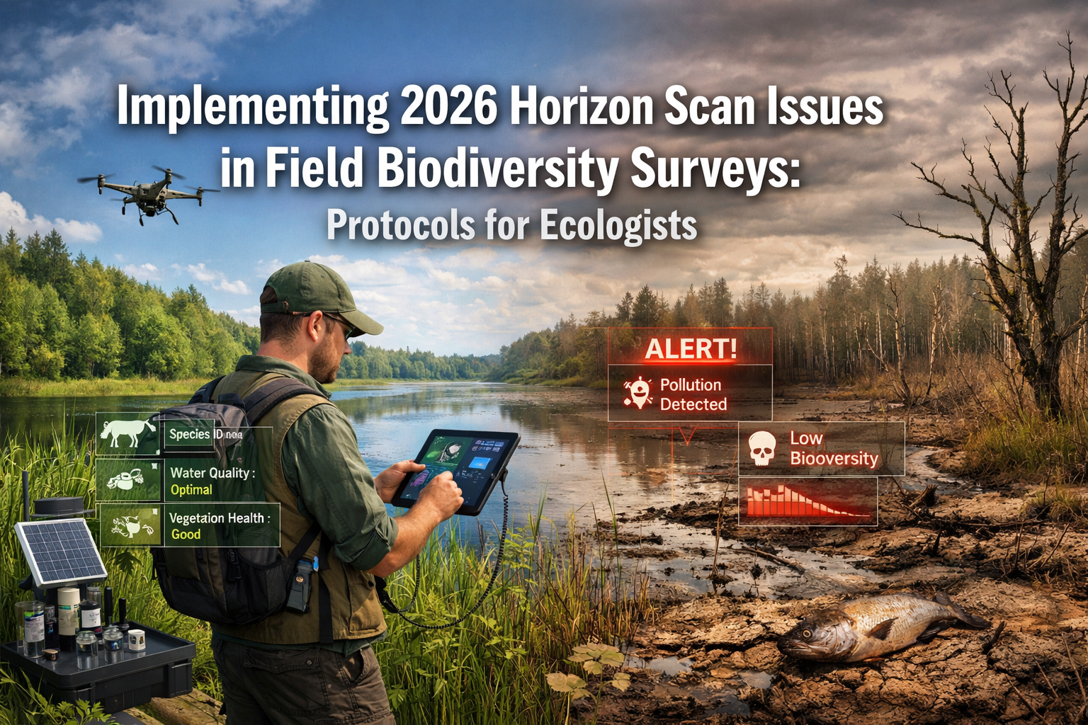
The landscape of biodiversity conservation is shifting beneath our feet—literally. As ecologists and field surveyors prepare for the 2026 field season, a groundbreaking set of emerging issues demands immediate integration into standard assessment protocols. The 2026 Global Horizon Scan, published in Trends in Ecology & Evolution, has identified 15 priority conservation challenges that will reshape how professionals conduct biodiversity surveys. Implementing 2026 Horizon Scan Issues in Field Biodiversity Surveys: Protocols for Ecologists is no longer optional—it's essential for capturing the full picture of ecosystem health in an era of rapid environmental change.
This comprehensive guide translates cutting-edge conservation science into actionable field protocols, enabling practitioners to document emerging threats like soil moisture decline, ocean darkening, and macroalgal habitat loss alongside traditional biodiversity metrics.
Key Takeaways
- 🔬 The 2026 Global Horizon Scan identified 15 priority conservation issues from 96 candidates through expert panel evaluation, representing critical emerging threats requiring immediate field protocol integration
- 🤖 TinyML devices and optical AI chips enable real-time biodiversity detection in remote locations without internet connectivity, revolutionizing field monitoring capabilities
- 🌍 Integrated assessment approaches that combine soil moisture monitoring, ocean light penetration measurements, and macroalgal habitat documentation provide comprehensive ecosystem health insights
- 📊 Field protocols must now address interconnected issues including food system shifts, Southern Ocean biophysical changes, and novel technologies affecting biodiversity
- ✅ Actionable implementation frameworks help ecologists systematically incorporate horizon scan priorities into existing survey methodologies
Understanding the 2026 Global Horizon Scan Framework
What Makes the 2026 Horizon Scan Different
The 2026 Global Horizon Scan represents the 17th iteration of an annual exercise that has become essential reading for conservation professionals worldwide. This year's scan involved a rigorous process: 26 scientists, practitioners, and policymakers evaluated 96 initial issues, engaged in detailed discussions about the top 35, and ultimately identified 15 priority concerns that ecologists must address in field assessments[3].
Unlike previous scans, the 2026 version emphasizes interconnected systems thinking. The identified issues aren't isolated threats—they represent cascading challenges that affect climate, biodiversity, water resources, and human wellbeing simultaneously[2]. For field ecologists, this means survey protocols must evolve beyond single-species counts or habitat classifications to capture complex interactions.
The 15 Priority Issues Requiring Field Integration
The horizon scan highlights several categories of emerging concerns:
Technology-Driven Monitoring Advances:
- Low-power Tiny Machine Learning (TinyML) devices for remote biodiversity detection
- Optical AI chips requiring minimal energy for species identification
- Digital twin simulations of ecological systems
Environmental Change Indicators:
- Soil moisture decline across terrestrial ecosystems
- Ocean darkening and reduced light penetration
- Macroalgal habitat loss in coastal zones
- Biophysical changes across the Southern Ocean
Anthropogenic Pressures:
- Shifts in global food demand affecting land-use patterns
- Deep-sea mining impacts on marine biodiversity
- Biodiversity damage from fiber optic drone cables
Novel Biological Concerns:
- Plant development chemicals affecting flowering patterns
- Effectiveness of soil inoculation techniques
- Unknown effects of mirror biomolecules
- Food production from plastic waste
For professionals working on biodiversity assessments, these issues represent new parameters that must be documented to ensure comprehensive ecosystem evaluation.
Implementing 2026 Horizon Scan Issues: Core Field Protocols
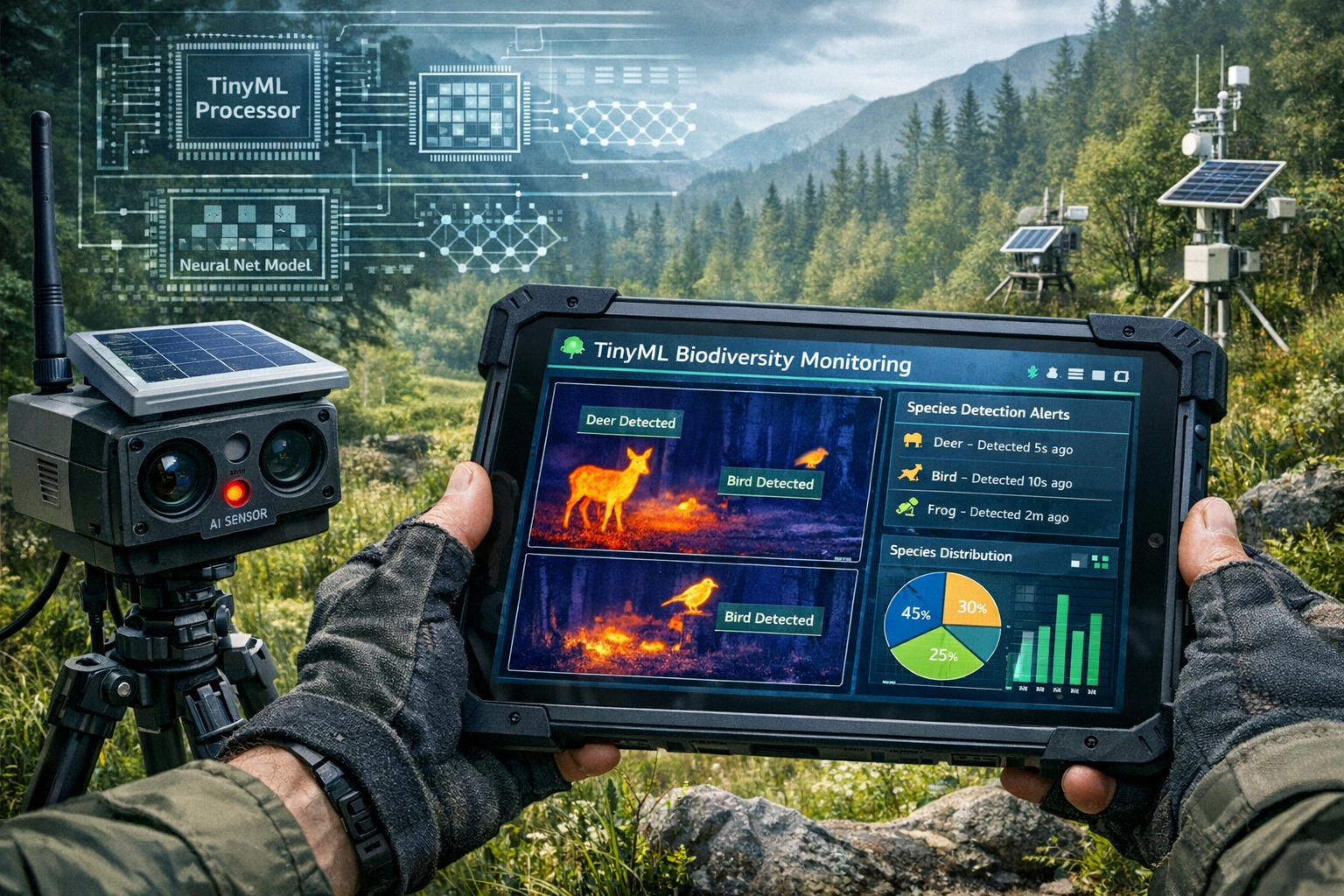
Protocol 1: Integrating TinyML Technology for Real-Time Monitoring
The emergence of Tiny Machine Learning devices represents a paradigm shift for field biodiversity surveys. These low-power devices operate without internet connectivity, making them ideal for remote landscape monitoring[2]. However, successful implementation requires careful protocol development.
Equipment Setup Guidelines:
| Component | Specification | Field Application |
|---|---|---|
| TinyML Device | <1W power consumption | Continuous species detection |
| Optical AI Chip | Solar-powered option | Image recognition in field |
| Data Storage | Local SD card (64GB+) | Offline data collection |
| Weatherproof Housing | IP67 rating minimum | Extended deployment periods |
Implementation Steps:
- Pre-Survey Calibration: Test TinyML devices against known species in controlled settings before field deployment
- Strategic Placement: Position devices at biodiversity hotspots identified through preliminary surveys
- Data Validation Protocol: Cross-reference AI detections with traditional observation methods during initial deployment phases
- Access Equity Considerations: Document device placement coordinates and ensure data sharing protocols address communities with limited digital infrastructure[2]
Field teams should recognize that while TinyML offers unprecedented monitoring capabilities, questions remain about data transparency and equitable access. Protocols must include provisions for community engagement and data sharing that don't require advanced technical infrastructure.
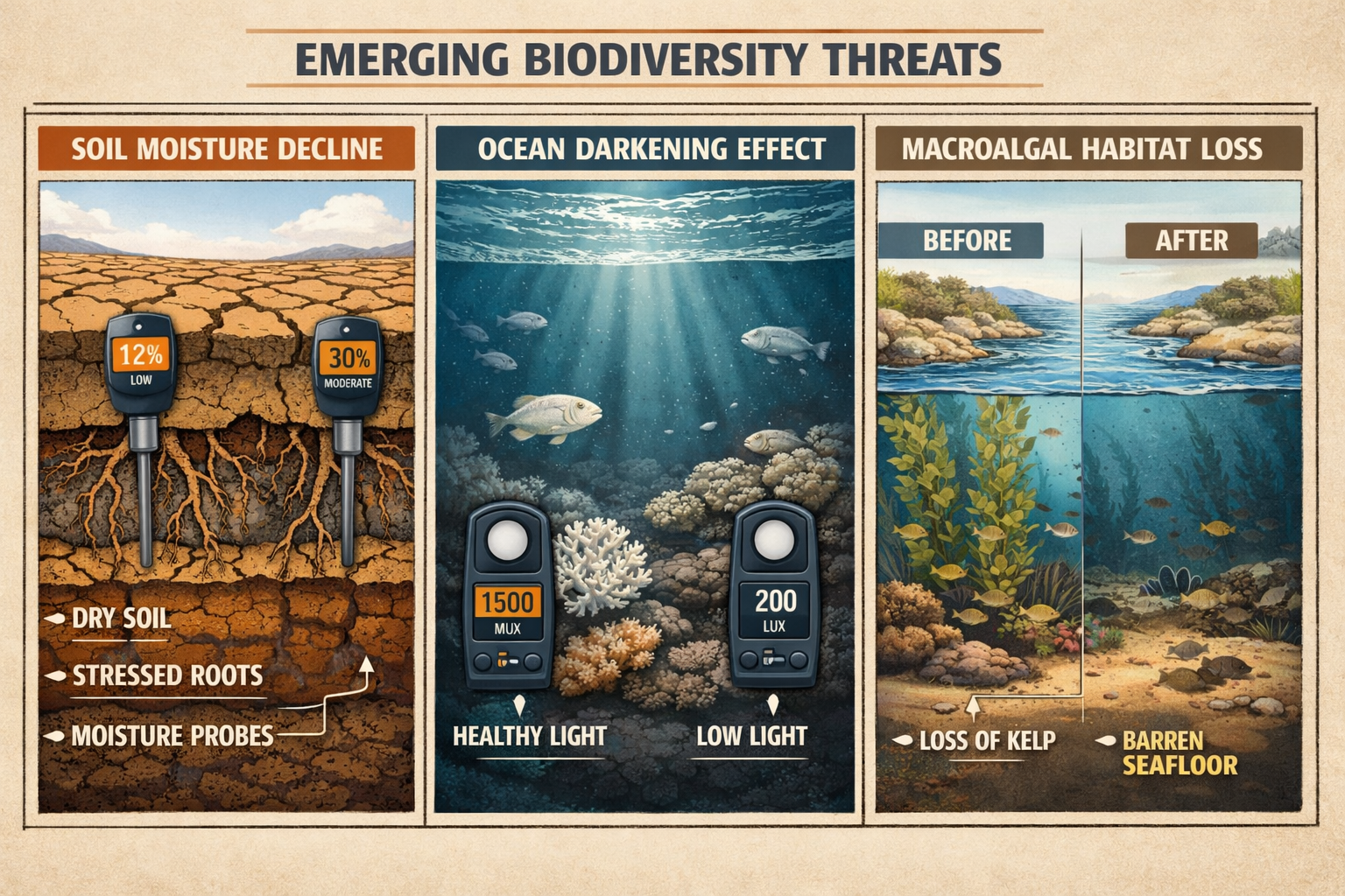
Protocol 2: Monitoring Soil Moisture Decline
Soil moisture decline has emerged as a critical indicator of ecosystem stress. Ecologists conducting biodiversity impact assessments must now incorporate systematic soil moisture monitoring into standard protocols.
Field Measurement Protocol:
Equipment Required:
- Theta probe or time-domain reflectometry (TDR) sensor
- GPS unit for precise location recording
- Soil sampling auger (0-30cm depth)
- Waterproof field notebook or tablet
Measurement Procedure:
- 📍 Establish a systematic grid across survey area (minimum 10 measurement points per hectare)
- 💧 Take measurements at consistent depths: 5cm, 15cm, and 25cm
- 📅 Record measurements at standardized times: early morning (6-8am) and late afternoon (4-6pm)
- 🌡️ Document concurrent temperature, recent precipitation, and vegetation cover
- 📊 Compare readings against historical baseline data for the region
Critical Considerations:
Soil moisture decline doesn't occur uniformly. Field protocols should document microhabitat variations that may indicate refugia where species can persist during drought conditions. These areas become critical for achieving biodiversity net gain in development projects.
Protocol 3: Assessing Ocean Darkening and Light Penetration
Ocean darkening—the reduction of light penetration through marine waters—affects photosynthetic organisms and entire food webs. For coastal ecologists, this emerging issue requires new measurement protocols.
Marine Light Assessment Method:
Equipment:
- Submersible photosynthetically active radiation (PAR) sensor
- Secchi disk for traditional visibility measurement
- Water sampling bottles for turbidity analysis
- Underwater camera with standardized white balance
Survey Protocol:
- Measure PAR at surface and at 1-meter depth intervals to seafloor or 30m maximum
- Calculate light attenuation coefficient using the formula: K = (ln(E₀) – ln(Ez)) / z
- Document water color using standardized Forel-Ule scale
- Collect water samples for laboratory analysis of suspended particles
- Photograph standardized color chart at various depths for visual documentation
Integration with Biodiversity Surveys:
Light penetration data should be correlated with:
- Seagrass bed extent and health
- Macroalgal community composition
- Fish species distribution patterns
- Coral bleaching indicators (where applicable)
This integrated approach aligns with biodiversity net gain principles by documenting baseline conditions that may change over project timelines.
Advanced Integration: Emerging Issues in Routine Assessments
Documenting Macroalgal Habitat Loss
Macroalgal forests—including kelp beds and other seaweed communities—provide critical ecosystem services but face unprecedented pressures. The 2026 Horizon Scan identifies their loss as a priority concern requiring systematic documentation[6].
Macroalgal Survey Protocol:
Transect Methodology:
- Establish permanent 50m transects perpendicular to shoreline
- Conduct surveys quarterly to capture seasonal variation
- Use SCUBA or snorkel depending on depth (<10m snorkel acceptable)
- Photograph every 5m along transect using quadrat frame (1m²)
Data Collection Parameters:
✅ Species composition (identify to species level where possible)
✅ Canopy height (measure from substrate to canopy top)
✅ Percentage cover (estimate within quadrat)
✅ Substrate type (rock, sand, mixed)
✅ Associated fauna (fish, invertebrates using habitat)
✅ Evidence of stress (bleaching, epiphyte load, herbivory damage)
Climate Change Correlation:
Document water temperature at each survey point. Rising temperatures correlate with macroalgal decline in many regions, making this data essential for biodiversity planning in coastal development projects.
Addressing Food System Shifts in Terrestrial Surveys
The horizon scan identifies shifts in global food demand as a key driver of biodiversity change. This includes unexpected factors like appetite-suppressing pharmaceuticals affecting land-use patterns[1][3]. Field ecologists must document indicators of changing agricultural pressures.
Agricultural Transition Indicators:
Field surveys should document:
- Land-use conversion evidence: Recent clearing, abandoned agricultural land, transitional vegetation
- Crop diversity changes: Monoculture expansion vs. diversified farming
- Livestock pressure indicators: Grazing intensity, trampling damage, manure presence
- Chemical application signs: Herbicide damage to non-target species, fertilizer runoff indicators
Protocol Integration:
When conducting surveys for biodiversity net gain assessments, include a 500m buffer zone analysis documenting agricultural intensification or de-intensification trends. This contextual information helps predict future pressures on surveyed habitats.
Plant Development Chemicals: Field Detection Methods
Scientists have identified chemical compounds that alter plant flowering patterns, with potential applications in conservation but also risks to wild populations[6]. Field protocols should now include indicators of unusual flowering phenology.
Phenological Anomaly Documentation:
🌸 Flowering timing deviations: Document species flowering outside normal seasonal windows
🌱 Growth pattern abnormalities: Stunted growth, excessive vegetative growth, delayed senescence
📸 Photographic evidence: Standardized photos of reproductive structures for temporal comparison
🔬 Tissue sampling: Collect leaf samples from anomalous plants for potential laboratory analysis
This documentation becomes particularly important near agricultural areas where such chemicals might be applied, affecting adjacent natural habitats.
Implementing 2026 Horizon Scan Issues: Digital Twins and Data Integration
Creating Digital Twin Models from Field Data
Digital twins—computer simulations of real-world ecological systems—represent an emerging tool identified in the horizon scan[2]. Field ecologists can contribute to these models through systematic data collection protocols.
Data Requirements for Digital Twin Development:
Field surveys should collect data in formats compatible with modeling:
- Georeferenced observations: All species records with precise GPS coordinates (±5m accuracy)
- Temporal standardization: Consistent survey timing across years
- Environmental covariates: Temperature, humidity, soil moisture, light levels at observation points
- Structural complexity metrics: Vegetation height, canopy closure, substrate heterogeneity
- Connectivity indicators: Corridor presence, barrier documentation, dispersal pathway mapping
Protocol Enhancement:
Traditional field forms should be supplemented with digital data collection using tablets or smartphones with offline capability. This enables immediate data validation and reduces transcription errors that compromise model development.
Southern Ocean and Deep-Sea Considerations
For ecologists working in marine environments, the horizon scan highlights biophysical changes across the Southern Ocean and impacts from deep-sea mining as critical emerging issues[2]. While many surveyors won't work directly in these environments, the principles apply to all marine surveys.
Proxy Indicator Monitoring:
Coastal surveys can document Southern Ocean changes through:
- Migratory species timing: Changes in arrival/departure dates for species with Southern Ocean connections
- Temperature anomalies: Unusual warm or cold water intrusions
- Species range shifts: Appearance of typically southern species in temperate zones
- Productivity indicators: Seabird breeding success, marine mammal body condition
These observations contribute to understanding large-scale oceanographic changes affecting biodiversity globally.
Practical Implementation: Integrating Horizon Scan Issues into Existing Workflows
Adapting Standard Survey Protocols
Most ecologists operate within established survey frameworks. Implementing 2026 Horizon Scan Issues in Field Biodiversity Surveys: Protocols for Ecologists doesn't require abandoning existing methods—it requires strategic augmentation.
Integration Framework:
| Existing Protocol | Horizon Scan Addition | Time Investment | Priority Level |
|---|---|---|---|
| Vegetation plot surveys | Soil moisture measurements | +10 minutes/plot | High |
| Bird point counts | TinyML device deployment | +5 minutes/point | Medium |
| Aquatic invertebrate sampling | Light penetration measurement | +15 minutes/site | High (coastal) |
| Mammal transects | Flowering phenology notes | +5 minutes/transect | Medium |
| Habitat mapping | Agricultural transition indicators | +20 minutes/survey | High |
Phased Implementation Approach:
Phase 1 (Immediate): Add soil moisture and phenological observations to all terrestrial surveys
Phase 2 (Within 6 months): Integrate TinyML devices at key monitoring sites
Phase 3 (Within 1 year): Develop site-specific digital twin data collection protocols
Phase 4 (Ongoing): Refine methods based on data quality assessment and emerging research
Training and Capacity Building
Successful implementation requires team training on new technologies and concepts. Organizations should:
- Conduct workshops on TinyML device operation and data interpretation
- Develop field guides illustrating horizon scan issues with local examples
- Create standardized data sheets incorporating new parameters
- Establish quality control procedures for novel data types
- Build partnerships with technology providers and academic institutions
For consultancies working on biodiversity net gain projects, this capacity building represents a competitive advantage and ensures comprehensive baseline assessments.
Addressing Equity and Access in Technology Implementation
Digital Infrastructure Challenges
The horizon scan explicitly raises concerns about equitable access to AI-powered monitoring technologies, particularly for communities with limited digital infrastructure[2]. Field protocols must address these disparities.
Inclusive Implementation Strategies:
🤝 Community partnerships: Engage local communities in device deployment and maintenance
📚 Capacity building: Provide training that doesn't assume advanced technical knowledge
💾 Offline-first design: Prioritize technologies that function without internet connectivity
🔓 Open data protocols: Ensure collected data is accessible to local stakeholders
🌐 Multi-language documentation: Translate protocols into languages spoken by field teams and communities
Ethical Considerations:
When deploying monitoring technologies in indigenous territories or community-managed lands, protocols should include:
- Prior informed consent procedures
- Data sovereignty agreements
- Benefit-sharing arrangements
- Cultural sensitivity in species documentation
- Recognition of traditional ecological knowledge
These considerations align with broader biodiversity conservation goals that recognize human communities as integral to ecosystem health.
Novel Issues Requiring Precautionary Documentation
Mirror Biomolecules and Emerging Biological Concerns
The horizon scan identifies unknown effects of mirror biomolecules—molecules with reversed stereochemistry—as an emerging conservation concern[3]. While field detection isn't currently possible, ecologists should document anomalous observations that might indicate novel biological impacts.
Anomaly Documentation Protocol:
Field teams should flag and photograph:
- Unusual mortality patterns without obvious cause
- Developmental abnormalities in multiple species
- Behavioral changes in wildlife populations
- Novel disease presentations
- Unexpected species interactions
These observations, while not immediately explained, create a record that future research can reference if mirror biomolecule effects become apparent.
Fiber Optic Drone Cables and Infrastructure Impacts
The scan identifies potential biodiversity damage from fiber optic drone cables used for internet connectivity[2]. This represents a new category of infrastructure impact requiring documentation.
Infrastructure Impact Assessment:
Surveys near drone cable installations should document:
- Bird collision evidence (feather piles, carcasses below cables)
- Bat activity changes (acoustic monitoring near cable routes)
- Behavioral avoidance (species distributions relative to cable locations)
- Vegetation damage from cable installation or maintenance
- Microclimate changes (shading effects, wind pattern alterations)
This proactive documentation helps establish baseline conditions before widespread deployment of such technologies.
Data Management and Reporting for Horizon Scan Issues
Standardized Data Formats
To maximize the value of horizon scan issue documentation, field data should follow standardized formats compatible with national and international biodiversity databases.
Recommended Data Standards:
- Darwin Core for species occurrence records
- Ecological Metadata Language (EML) for dataset descriptions
- GeoJSON for spatial data
- NetCDF for environmental measurements (soil moisture, light penetration)
- MPEG-4 for TinyML device video/audio recordings
Metadata Requirements:
All horizon scan observations should include:
✓ Date and time (ISO 8601 format)
✓ Precise location (decimal degrees, WGS84 datum)
✓ Observer name and qualifications
✓ Detection method (visual, acoustic, camera trap, TinyML, etc.)
✓ Environmental conditions
✓ Quality control flags
✓ Uncertainty estimates
Reporting Frameworks for Development Projects
For ecologists working on development projects requiring biodiversity assessments, horizon scan issues should be integrated into standard reporting structures.
Report Section Additions:
Executive Summary: Highlight any critical horizon scan issues detected
Methodology: Describe protocols for soil moisture, light penetration, and other novel parameters
Baseline Conditions: Present horizon scan data alongside traditional biodiversity metrics
Impact Assessment: Evaluate project effects on emerging issues (soil moisture changes, light pollution, etc.)
Mitigation Measures: Propose actions addressing horizon scan concerns
Monitoring Plan: Include horizon scan parameters in long-term monitoring protocols
This comprehensive approach ensures that biodiversity net gain strategies address both current and emerging conservation priorities.
Case Study Applications: Horizon Scan Protocols in Action
Terrestrial Development Project Example
Scenario: Mixed-use development on 50-hectare site with agricultural land and woodland fragments.
Horizon Scan Protocol Implementation:
- Soil Moisture Baseline: Established 100-point grid with quarterly measurements, identifying drought-resistant refugia in north-facing slopes
- TinyML Deployment: Installed 15 devices capturing nocturnal species missed by traditional surveys, detecting protected bat species
- Phenological Monitoring: Documented flowering patterns across two seasons, establishing baseline for detecting chemical impacts
- Agricultural Transition: Mapped recent land-use changes in 500m buffer, identifying intensification pressure from neighboring farms
- Digital Twin Data: Collected high-resolution environmental covariates enabling predictive modeling of post-development conditions
Outcome: Enhanced baseline assessment informed site design that preserved drought refugia and established monitoring program addressing emerging threats. Project achieved 10% biodiversity net gain with confidence in long-term sustainability.
Coastal Infrastructure Project Example
Scenario: Port expansion affecting 2km of coastline with macroalgal beds.
Horizon Scan Protocol Implementation:
- Ocean Darkening Assessment: Quarterly light penetration surveys established baseline PAR profiles, identifying critical depth thresholds for macroalgae
- Macroalgal Monitoring: Permanent transects documented species composition, canopy structure, and associated fauna
- Southern Ocean Indicators: Recorded water temperature anomalies and migratory species timing changes
- Impact Prediction: Modeled turbidity increases from construction, predicting light reduction zones
- Mitigation Design: Proposed turbidity curtains and construction timing to minimize ocean darkening impacts
Outcome: Project redesign reduced footprint in critical macroalgal habitat, implemented real-time turbidity monitoring, and established long-term ocean darkening surveillance program.
Future-Proofing Field Protocols
Adaptive Management for Emerging Issues
The horizon scan process is annual, meaning new issues will emerge each year. Field protocols must be adaptive rather than static.
Protocol Review Cycle:
- Annual review: Assess new horizon scan publications each January
- Quarterly updates: Integrate relevant emerging issues into active surveys
- Peer exchange: Participate in professional networks sharing implementation experiences
- Technology assessment: Evaluate new monitoring tools as they become available
- Data analysis: Review collected horizon scan data to refine protocols
Building Institutional Capacity
Organizations conducting biodiversity surveys should develop institutional frameworks supporting horizon scan integration:
Capacity Building Elements:
📋 Protocol library: Maintain updated field protocols for all horizon scan issues
🎓 Training program: Regular workshops on emerging conservation science
💻 Technology investment: Budget allocation for new monitoring equipment
🔗 Partnership network: Relationships with academic institutions and technology developers
📊 Data infrastructure: Systems capable of handling diverse data types from emerging issues
For consultancies, this capacity building demonstrates commitment to best practices and positions the organization as a leader in comprehensive biodiversity assessment.
Conclusion
Implementing 2026 Horizon Scan Issues in Field Biodiversity Surveys: Protocols for Ecologists represents a fundamental evolution in conservation practice. The 15 priority issues identified through rigorous expert evaluation—from TinyML monitoring technologies to soil moisture decline, ocean darkening, and macroalgal habitat loss—demand immediate integration into field assessment protocols. Traditional survey methods, while still valuable, no longer capture the full complexity of ecosystem health in an era of rapid environmental change.
This guide has provided actionable frameworks for ecologists to systematically incorporate horizon scan priorities into existing workflows. By adding soil moisture measurements to vegetation plots, deploying TinyML devices at monitoring sites, assessing light penetration in coastal waters, and documenting macroalgal habitat conditions, field teams can generate comprehensive baseline data addressing both current and emerging conservation challenges.
The integrated approach emphasized throughout these protocols—recognizing interconnections between climate, biodiversity, water resources, and human wellbeing—aligns with modern conservation science while remaining practical for field implementation. Whether conducting surveys for development projects, protected area management, or long-term ecological monitoring, these enhanced protocols ensure that collected data remains relevant as new threats emerge.
Actionable Next Steps
For ecologists and survey teams ready to implement these protocols:
-
Review your existing survey methodologies and identify where horizon scan parameters can be added with minimal time investment (start with soil moisture and phenological observations)
-
Invest in key technologies including soil moisture sensors, PAR meters for marine work, and explore TinyML device options for your focal ecosystems
-
Develop standardized data collection forms that incorporate horizon scan parameters alongside traditional metrics, ensuring compatibility with digital twin modeling
-
Establish training programs for field staff on new technologies and emerging conservation issues, building organizational capacity for adaptive protocol management
-
Engage with professional networks sharing implementation experiences, contributing to the collective knowledge base on effective horizon scan integration
-
Incorporate horizon scan issues into project proposals and reports, demonstrating comprehensive assessment approaches that address both immediate and emerging biodiversity concerns
The 2026 field season presents an opportunity to pioneer these enhanced protocols, generating data that will inform conservation decisions for decades to come. By embracing these emerging issues now, ecologists ensure their work remains at the forefront of biodiversity science, delivering insights that truly capture ecosystem complexity in a changing world.
References
[1] A Horizon Scan Of Biological Conservation Issues For 2026 – https://www.besnet.world/library/a-horizon-scan-of-biological-conservation-issues-for-2026/
[2] Whats Next For Biodiversity Conservation Insights From The 2026 Horizon Scan – https://www.unep-wcmc.org/en/news/whats-next-for-biodiversity-conservation-insights-from-the-2026-horizon-scan
[3] A Horizon Scan Of Biological Conservation Issues For 2026 – https://www.bas.ac.uk/data/our-data/publication/a-horizon-scan-of-biological-conservation-issues-for-2026/
[6] Conservation Horizon Scan Ai Drought Climate Change Tropical Forests Seaweed Southern Ocean – https://www.theinvadingsea.com/2026/01/02/conservation-horizon-scan-ai-drought-climate-change-tropical-forests-seaweed-southern-ocean/
