
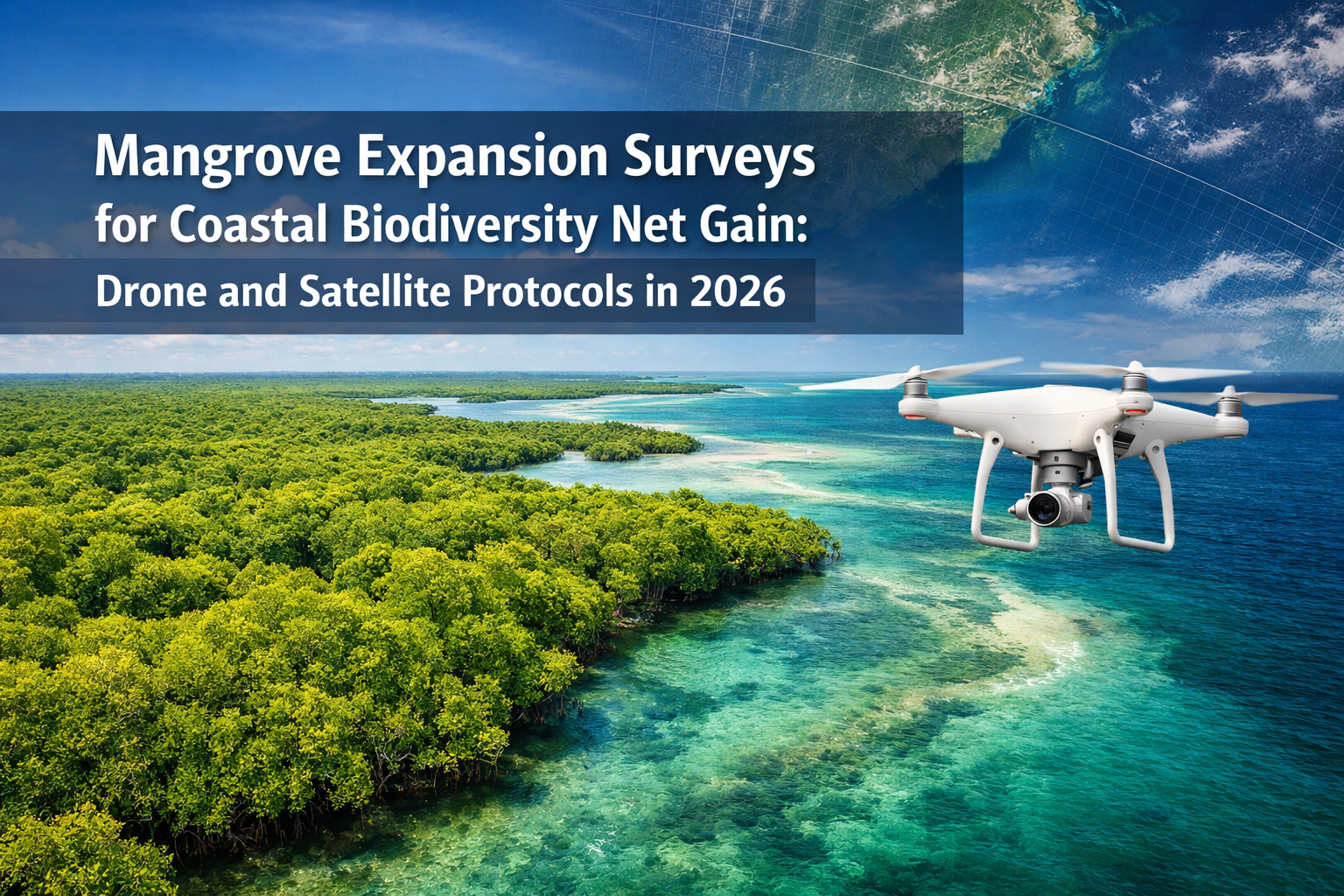
Mangrove forests are expanding northward along Atlantic coastlines at unprecedented rates, with climate modeling projecting significant range shifts over the coming decades[4]. This migration presents both challenges and opportunities for coastal biodiversity net gain (BNG) strategies, requiring innovative survey protocols that combine cutting-edge drone technology with satellite monitoring to accurately measure ecosystem changes amid rising sea levels. Mangrove Expansion Surveys for Coastal Biodiversity Net Gain: Drone and Satellite Protocols in 2026 now employ sophisticated hybrid approaches that capture both fine-scale habitat details and continental-scale trends, enabling conservation planners and developers to quantify ecological value with unprecedented precision.
The stakes are high: mangroves provide critical ecosystem services including carbon sequestration, coastal protection, and nursery habitat for marine species. As these forests migrate into new territories, accurate surveying becomes essential for calculating biodiversity credits, validating restoration projects, and ensuring compliance with environmental regulations.
Key Takeaways
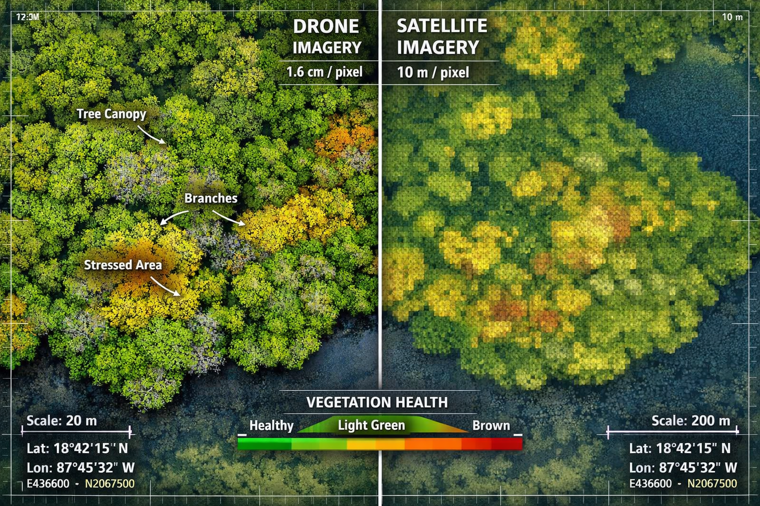
- Ultra-high resolution drone imaging achieves 1.6 cm spatial resolution per pixel—over 600 times more detailed than standard satellite imagery—enabling precise mangrove health assessments[1]
- Three primary analysis methods dominate 2026 protocols: Green Chromatic Coordinate (GCC) for vegetation greenness, pixel-based classification using reflectance contrasts, and object-based classification grouping features by shape and reflectance[1]
- Hybrid remote-field approaches overcome individual technology limitations by combining drone precision with satellite coverage and ground-truthing validation
- Continental-scale monitoring using multi-sensor Earth observation tracks mangrove loss from aquaculture expansion across Asian coastal regions[2]
- Climate-driven range expansion along Atlantic coasts creates new opportunities for coastal BNG projects but requires adaptive survey protocols[4]
Understanding Mangrove Expansion as Climate Adaptation
Mangrove forests are responding dynamically to climate change, particularly along temperate coastlines where warming temperatures enable tropical species to establish in previously unsuitable habitats. Species distribution modeling research indicates that mangrove range expansion potential along the Atlantic coast from Florida will continue throughout the coming century, driven primarily by climate factors and habitat connectivity[4].
This northward migration represents a natural climate adaptation strategy with profound implications for biodiversity net gain planning. Unlike static ecosystems, expanding mangrove systems require survey protocols that account for:
- Dynamic boundaries that shift seasonally and annually
- Transition zones where mangroves gradually replace salt marsh vegetation
- Variable establishment success depending on local conditions
- Sea-level rise impacts that accelerate inland migration
The BNG Context for Coastal Ecosystems 🌊
Traditional biodiversity net gain assessments focus on terrestrial habitats with relatively stable boundaries. Coastal ecosystems like mangroves challenge these assumptions. Achieving biodiversity net gain without risk in these environments requires understanding that:
- Baseline conditions change naturally over short timeframes
- Habitat quality varies with tidal cycles, salinity gradients, and storm impacts
- Carbon storage potential adds significant ecosystem value beyond species diversity
- Connectivity to marine systems multiplies ecological benefits
For developers and conservation planners working in coastal zones, these factors necessitate more sophisticated survey approaches than standard habitat assessments provide.
Drone Technology: High-Resolution Mangrove Mapping Protocols
The revolution in Mangrove Expansion Surveys for Coastal Biodiversity Net Gain: Drone and Satellite Protocols in 2026 centers on unmanned aerial vehicle (UAV) capabilities that deliver unprecedented spatial detail. Modern drone orthomosaics achieve 1.6 cm spatial resolution per pixel—compared to 10-meter resolution in standard satellite imagery—enabling detailed mangrove health assessments and validation of large-scale satellite data[1].
Technical Specifications for 2026 Drone Surveys
| Parameter | Specification | Purpose |
|---|---|---|
| Spatial Resolution | 1.6 cm per pixel | Individual tree crown delineation |
| Flight Altitude | 80-120 meters | Balance between coverage and detail |
| Overlap | 75% forward, 65% side | Accurate 3D reconstruction |
| Sensor Type | RGB + Multispectral | Vegetation health analysis |
| Flight Speed | 5-8 m/s | Image quality optimization |
| Weather Window | Clear skies, <15 km/h wind | Data consistency |
Three Primary Analysis Methods
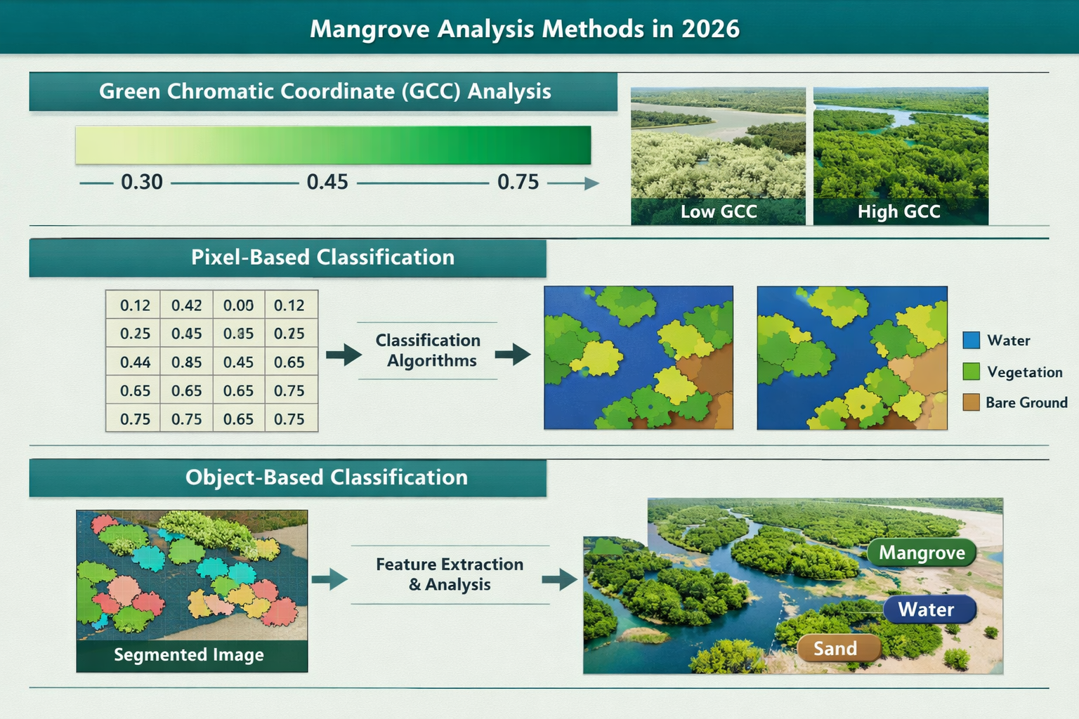
Current 2026 research employs three distinct analytical approaches for processing drone-captured mangrove imagery[1]:
1. Green Chromatic Coordinate (GCC) Analysis
This method measures vegetation "greenness" by calculating the ratio of green reflectance to total visible light reflectance. GCC values provide a straightforward indicator of:
- Overall canopy health and vigor
- Seasonal phenological changes
- Stress responses to salinity or drought
- Recovery trajectories after disturbance events
2. Pixel-Based Classification
This approach uses light reflectance contrasts to distinguish mangrove vegetation from other land cover types. The technique excels at:
- Sharp boundary delineation between mangroves and adjacent habitats
- Species-level differentiation when spectral signatures are distinct
- Change detection by comparing multi-temporal datasets
- Automated processing of large survey areas
3. Object-Based Classification
Rather than analyzing individual pixels in isolation, this method groups neighboring pixels by average reflectance and shape features[1]. Benefits include:
- ✅ Reduced "salt and pepper" noise in classification outputs
- ✅ Integration of texture and context information
- ✅ More accurate representation of real-world habitat patches
- ✅ Better performance in heterogeneous canopy conditions
Overcoming Environmental Limitations
Drones provide critical advantages over traditional survey methods by overcoming atmospheric conditions and satellite revisit frequency limitations that affect conventional mapping, while remaining less invasive than on-site surveying methods[1]. This is particularly valuable for:
- Cloud-prone tropical regions where satellite imagery is frequently obscured
- Rapid response surveys following storm events or development impacts
- Sensitive nesting areas where ground access would disturb wildlife
- Tidal zone mapping that requires precise timing coordination
However, UAV RGB workflows effectively delineate mangrove cover extent, but accurate density estimation in heterogeneous canopies requires native-resolution processing or integration of complementary active sensors like Light Detection and Ranging (LiDAR)[3]. This limitation drives the need for hybrid survey approaches discussed below.
Satellite Monitoring: Continental-Scale Biodiversity Tracking
While drones excel at site-specific detail, Mangrove Expansion Surveys for Coastal Biodiversity Net Gain: Drone and Satellite Protocols in 2026 rely heavily on satellite platforms for broader context and temporal monitoring. A 2026 continental-scale assessment of Asian mangrove loss utilizes Sentinel-1/-2 optical and radar time series, Landsat archive imagery, and the Global Mangrove Watch (GMW) dataset to quantify mangrove forest decline from aquaculture expansion[2].
Multi-Sensor Earth Observation Approach
Advanced satellite Earth observation technologies enable accurate quantification and monitoring of mangrove loss at continental scales, providing timely, spatially detailed ecosystem change insights[2]. The integrated approach combines:
Optical Sensors (Sentinel-2, Landsat)
- 10-30 meter spatial resolution
- Multispectral bands optimized for vegetation analysis
- 5-16 day revisit frequency
- Free, open-access data archives extending decades
Radar Sensors (Sentinel-1)
- Cloud-penetrating capability essential for tropical regions
- Sensitivity to vegetation structure and moisture
- Day/night acquisition capability
- Consistent performance regardless of weather
Reference Datasets (Global Mangrove Watch)
- Standardized mangrove extent baselines
- Change detection algorithms
- Quality-controlled validation data
- Harmonized global coverage
Quantifying Threats: Aquaculture Expansion Monitoring
Research demonstrates that aquaculture pond expansion is a principal driver of mangrove loss in critical Asian coastal regions, with particular severity in Southeast Asia[2]. Satellite protocols now routinely identify and measure:
- Pond construction patterns and expansion rates
- Illegal clearing in protected mangrove areas
- Cumulative impacts across entire coastal watersheds
- Restoration potential in abandoned aquaculture sites
For biodiversity net gain assessment purposes, this continental-scale monitoring provides essential context. Developers proposing coastal projects can demonstrate net positive outcomes by:
- Avoiding high-value mangrove areas identified through satellite analysis
- Restoring degraded sites detected in historical imagery
- Creating buffer zones that enhance connectivity between existing mangrove patches
- Monitoring long-term outcomes using freely available satellite data
Temporal Resolution and Change Detection
One of satellite monitoring's greatest strengths for BNG applications is the ability to establish defensible baselines and track changes over multi-year periods. Standard protocols now include:
- Pre-development baseline (minimum 3-year historical average)
- Construction phase monitoring (quarterly assessments)
- Post-development tracking (annual surveys for 30-year habitat maturation period)
- Reference site comparison (control areas demonstrating natural variability)
This temporal depth is critical for achieving 10% biodiversity net gain targets, as it allows accurate measurement of habitat trajectory rather than single-point-in-time snapshots.
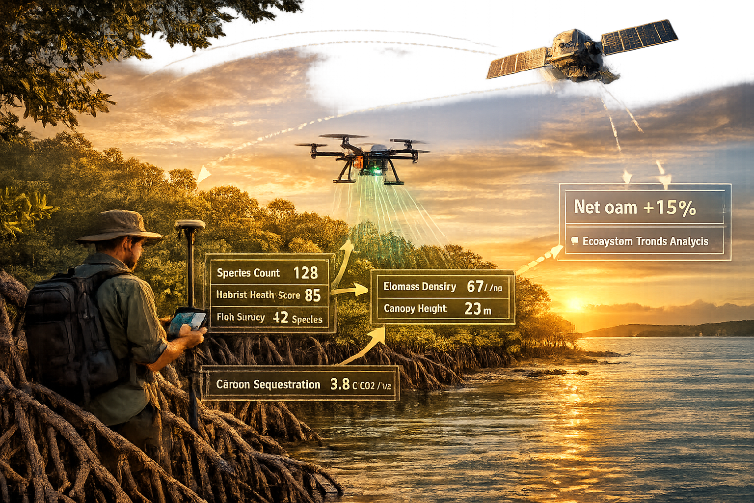
Hybrid Remote-Field Survey Protocols for Accurate BNG Metrics
The most robust Mangrove Expansion Surveys for Coastal Biodiversity Net Gain: Drone and Satellite Protocols in 2026 integrate multiple data sources to overcome individual technology limitations while maximizing accuracy and cost-effectiveness.
The Three-Tier Survey Framework
Tier 1: Satellite Context (Regional Scale)
- Initial site screening and threat assessment
- Historical change detection
- Connectivity analysis with surrounding habitats
- Long-term monitoring throughout project lifecycle
Tier 2: Drone Detail (Site Scale)
- High-resolution baseline mapping
- Species composition analysis
- Structural complexity assessment
- Validation of satellite-derived classifications
Tier 3: Field Verification (Plot Scale)
- Ground-truthing of remote sensing interpretations
- Biodiversity inventory (birds, fish, invertebrates)
- Soil and water quality sampling
- Carbon stock measurements
Integration Workflow for BNG Calculations
The hybrid protocol follows this systematic workflow:
-
Preliminary Assessment 📊
- Satellite imagery review identifies mangrove extent and condition
- Historical analysis establishes baseline trajectory
- Threat mapping highlights pressures (development, aquaculture, erosion)
-
Detailed Survey Design
- Stratified sampling based on satellite-identified habitat zones
- Drone flight planning optimized for tidal conditions
- Field plot placement in representative areas
-
Data Collection
- Drone surveys capture ultra-high-resolution imagery
- Multispectral sensors measure vegetation indices
- LiDAR integration provides canopy structure data[3]
- Field teams collect biodiversity and environmental data
-
Analysis and Metric Calculation
- Object-based classification delineates habitat patches
- GCC analysis quantifies vegetation health
- Biodiversity metrics calculated following standard protocols
- Carbon sequestration potential estimated from structural data
-
BNG Metric Derivation
- Habitat distinctiveness scores assigned
- Condition assessment based on multiple indicators
- Strategic significance evaluated (connectivity, rarity)
- Biodiversity units calculated using standardized methodology
Addressing Density Estimation Challenges
A critical limitation identified in 2026 research is that UAV RGB workflows effectively delineate mangrove cover extent, but accurate density estimation in heterogeneous canopies requires native-resolution processing or integration of complementary active sensors like LiDAR[3]. This matters for BNG because:
- Structural complexity correlates with biodiversity value
- Canopy gaps indicate disturbance or poor establishment
- Vertical stratification provides diverse microhabitats
- Biomass estimates drive carbon credit calculations
Best practice protocols now routinely incorporate LiDAR data collection during drone surveys, despite higher equipment costs. The investment pays dividends through:
- More accurate habitat condition assessments
- Defensible carbon offset claims
- Better prediction of habitat trajectory
- Reduced uncertainty in BNG calculations
Quality Assurance and Validation
To ensure survey results meet regulatory standards, 2026 protocols include rigorous quality control:
✓ Independent peer review of classification accuracy
✓ Confusion matrix analysis comparing automated classifications to expert interpretation
✓ Field validation of at least 10% of mapped area
✓ Temporal consistency checks across multi-year datasets
✓ Cross-sensor calibration between drone and satellite measurements
For developers working with biodiversity surveyors on BNG strategies, these quality assurance measures provide confidence that survey results will withstand regulatory scrutiny and support planning applications.
Sea-Level Rise Adaptation in Survey Design
Climate change adds complexity to Mangrove Expansion Surveys for Coastal Biodiversity Net Gain: Drone and Satellite Protocols in 2026 through accelerating sea-level rise. Coastal BNG projects must account for:
Dynamic Baseline Conditions
Traditional habitat surveys assume relatively stable conditions. Mangrove systems under sea-level rise pressure experience:
- Landward migration as tidal inundation increases
- Seaward edge erosion from wave action
- Vertical accretion through sediment trapping
- Species composition shifts as salinity regimes change
Survey protocols now incorporate sea-level rise projections into baseline assessments, recognizing that "no net loss" may require accounting for natural habitat migration.
Migration Corridor Identification
For off-site biodiversity net gain delivery, identifying areas where mangroves can naturally expand becomes critical. Satellite and drone surveys combined with elevation data pinpoint:
- Low-lying coastal areas suitable for future mangrove establishment
- Barriers to migration (seawalls, development, topographic constraints)
- Connectivity pathways enabling species dispersal
- Land-use conflicts requiring resolution
This forward-looking approach aligns with climate adaptation strategies while delivering measurable biodiversity gains.
Monitoring Protocol Adjustments
Long-term monitoring of coastal BNG projects requires flexibility as environmental conditions shift:
- Boundary adjustments reflecting natural habitat migration
- Success criteria updates based on climate-adjusted reference conditions
- Adaptive management triggers when trajectories deviate from predictions
- Enhanced reporting frequency during rapid change periods
Regulatory Compliance and Reporting Standards
Mangrove Expansion Surveys for Coastal Biodiversity Net Gain: Drone and Satellite Protocols in 2026 must meet evolving regulatory requirements across multiple jurisdictions. Key compliance considerations include:
Data Standards and Interoperability
Regulatory agencies increasingly require standardized data formats enabling:
- Cross-project comparison and aggregation
- Integration with national biodiversity monitoring systems
- Public transparency and stakeholder access
- Long-term data archiving and retrieval
Survey protocols should deliver outputs in formats compatible with:
- National habitat classification systems
- Biodiversity metric calculation tools
- Geographic information systems (GIS) platforms
- Carbon accounting frameworks
Documentation Requirements
Comprehensive BNG reports for coastal mangrove projects typically include:
- Methodology statement detailing survey protocols
- Baseline habitat assessment with supporting imagery
- Impact predictions for proposed development
- Mitigation hierarchy application (avoid, minimize, restore, offset)
- Net gain calculations showing 10%+ improvement
- Monitoring and management plan for 30-year period
- Contingency measures if targets are not met
Professional Competency Standards
The technical sophistication of hybrid drone-satellite surveys requires appropriately qualified professionals. Survey teams should include:
- Remote sensing specialists with UAV pilot certification
- Ecologists experienced in coastal habitat assessment
- GIS analysts capable of multi-sensor data integration
- Project managers understanding BNG regulatory frameworks
Cost-Benefit Analysis: Investing in Advanced Survey Protocols
While sophisticated Mangrove Expansion Surveys for Coastal Biodiversity Net Gain: Drone and Satellite Protocols in 2026 require upfront investment, they deliver substantial value through:
Reduced Project Risk
Accurate baseline surveys minimize the risk of:
- Planning application rejection due to inadequate assessment
- Unexpected protected species discoveries during construction
- Failure to achieve BNG targets requiring costly remediation
- Reputational damage from environmental incidents
Enhanced Biodiversity Credit Value
High-quality survey data supports premium pricing for biodiversity units by demonstrating:
- Rigorous scientific methodology
- Defensible habitat condition assessments
- Robust monitoring and verification systems
- Additionality beyond regulatory minimums
Operational Efficiency Gains
Hybrid protocols deliver efficiency through:
- Rapid data collection covering large areas quickly
- Reduced field time in difficult-to-access coastal environments
- Automated processing of imagery using AI/machine learning
- Multi-purpose datasets serving BNG, carbon, and conservation goals
Long-Term Monitoring Cost Savings
Satellite-based monitoring provides cost-effective long-term tracking:
- Free data access eliminates ongoing acquisition costs
- Automated change detection reduces analyst time
- Consistent methodology enables valid temporal comparisons
- Early warning of habitat degradation enables proactive management
Case Study Applications: Mangrove BNG in Practice
Southeast Asian Aquaculture Restoration
Following satellite detection of extensive mangrove loss to aquaculture ponds[2], a regional restoration initiative employed hybrid surveys to:
- Map 50,000 hectares of degraded coastal habitat
- Identify 12,000 hectares suitable for mangrove restoration
- Calculate potential biodiversity units from restoration
- Design monitoring protocols tracking recovery over 10 years
Drone surveys at 1.6 cm resolution[1] enabled precise measurement of seedling establishment and survival rates, while satellite monitoring tracked landscape-scale connectivity improvements.
Atlantic Coast Climate Adaptation Corridor
Responding to projected mangrove range expansion[4], coastal managers established a migration corridor incorporating:
- Satellite-based identification of suitable expansion zones
- Drone surveys documenting current mangrove-salt marsh transition zones
- Field verification of soil conditions and elevation gradients
- Predictive modeling of future habitat distribution
The project generated biodiversity credits by removing migration barriers and enhancing connectivity, with survey protocols providing baseline data for 30-year monitoring.
Future Directions: Emerging Technologies and Methods
The field of Mangrove Expansion Surveys for Coastal Biodiversity Net Gain: Drone and Satellite Protocols in 2026 continues evolving rapidly. Emerging developments include:
Artificial Intelligence Integration
Machine learning algorithms increasingly automate:
- Species-level classification from multispectral imagery
- Individual tree crown delineation and counting
- Health status assessment from spectral signatures
- Change detection and anomaly identification
Hyperspectral Imaging
Next-generation sensors capturing hundreds of narrow spectral bands enable:
- Biochemical composition analysis (chlorophyll, nitrogen)
- Early stress detection before visible symptoms
- Species discrimination in mixed stands
- Water quality assessment in adjacent estuaries
Autonomous Survey Systems
Fully automated platforms reduce costs and increase temporal resolution:
- Scheduled repeat surveys without human intervention
- Real-time data processing and alert generation
- Integration with weather forecasting for optimal timing
- Continuous monitoring of high-priority sites
Blockchain Verification
Distributed ledger technology provides:
- Tamper-proof survey data archiving
- Transparent biodiversity credit tracking
- Automated compliance verification
- Stakeholder confidence in reported outcomes
Conclusion
Mangrove Expansion Surveys for Coastal Biodiversity Net Gain: Drone and Satellite Protocols in 2026 represent a sophisticated integration of remote sensing technology, ecological science, and regulatory compliance. As mangrove forests respond to climate change through range expansion and migration, these hybrid survey approaches provide the accuracy and scale necessary to measure biodiversity outcomes amid dynamic environmental conditions.
The combination of ultra-high-resolution drone imagery achieving 1.6 cm per pixel[1], continental-scale satellite monitoring[2], and strategic field verification creates a robust framework for coastal BNG projects. This three-tier approach overcomes individual technology limitations while delivering defensible metrics for regulatory compliance and biodiversity credit generation.
Actionable Next Steps
For developers, conservation planners, and environmental professionals working on coastal projects:
- Assess project requirements against the three-tier survey framework to determine appropriate technology mix
- Engage qualified professionals with demonstrated expertise in hybrid remote-field survey protocols
- Review biodiversity net gain strategies specific to coastal ecosystems and climate adaptation
- Incorporate sea-level rise projections into baseline assessments and long-term monitoring plans
- Establish partnerships with satellite data providers and drone service operators
- Budget appropriately for upfront survey investment recognizing long-term value and risk reduction
- Plan for 30-year monitoring using cost-effective satellite platforms supplemented with periodic drone surveys
The future of coastal biodiversity conservation lies in embracing these advanced survey protocols. By accurately measuring mangrove expansion and ecosystem health, we can ensure that development proceeds with genuine net gains for nature, creating resilient coastal landscapes that benefit both human communities and the diverse species these critical habitats support.
As climate change accelerates and regulatory requirements strengthen, the projects that succeed will be those built on foundations of rigorous, scientifically defensible survey data. The tools and protocols are available—the imperative now is implementation.
References
[1] Mangrove Conservation – https://geonadir.com/mangrove-conservation/
[2] Egu26 10584 – https://meetingorganizer.copernicus.org/EGU26/EGU26-10584.html
[3] 2026.468 481 – https://bioflux.com.ro/docs/2026.468-481.pdf
[4] Climate And Connectivity Drive Mangrove Range Expansion – https://conservationcorridor.org/digests/2026/02/climate-and-connectivity-drive-mangrove-range-expansion/
