
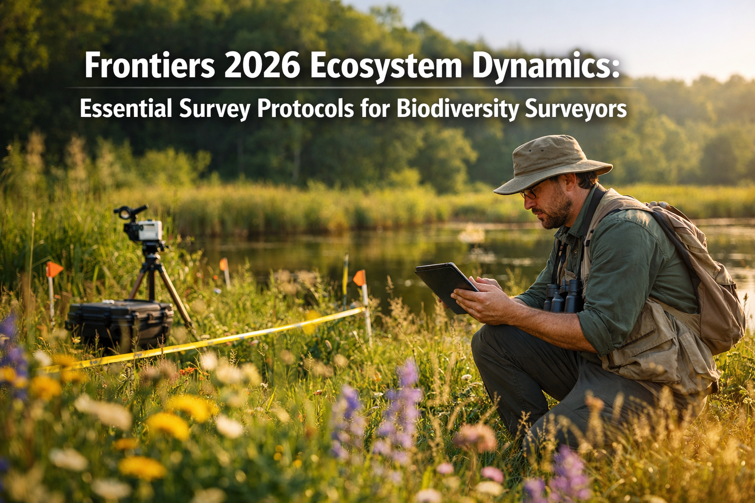
Recent analysis of 40 years of Lake Geneva ecological data reveals that species' variable responses to environmental changes—termed "response diversity"—stabilize ecosystem biomass more effectively than previously understood, fundamentally reshaping how biodiversity surveyors must approach field assessments in 2026.[2] This breakthrough, published in March 2026, arrives precisely as UK policy shifts demand more rigorous verification methods for Biodiversity Net Gain (BNG) compliance. The convergence of cutting-edge research from Frontiers journals and practical regulatory requirements creates an urgent need for biodiversity surveyors to adopt Frontiers 2026 Ecosystem Dynamics: Essential Survey Protocols for Biodiversity Surveyors from Latest Research Topics that reflect these scientific advances.
The landscape of ecological surveying has transformed dramatically. Traditional static assessment methods no longer capture the dynamic, context-dependent nature of species responses that recent research has illuminated. For professionals conducting biodiversity impact assessments, understanding these new protocols isn't optional—it's essential for delivering scientifically defensible results that meet 2026 regulatory standards.
Key Takeaways
- 🔬 Response diversity frameworks published in March 2026 demonstrate that species reactions vary dynamically with environmental context, requiring surveyors to abandon equilibrium-based assessment assumptions
- 📊 The new estar R package standardizes eleven ecosystem stability indicators, providing biodiversity surveyors with open-source tools for quantifying community resilience at multiple scales
- 🌍 Frontiers research topics for 2026 emphasize multi-source remote sensing integration and sustainability strategies that directly inform scalable BNG verification methods
- ⏱️ Time-varying stabilization effects mean survey protocols must capture temporal dynamics rather than single-point assessments to accurately measure ecosystem health
- 🔗 Jacobian matrix approaches enable short and long-term stability measurement through species interaction mapping, offering mathematical rigor for complex community assessments
Understanding the 2026 Ecosystem Dynamics Research Revolution
The Response Diversity Framework Changes Everything
The March 2026 publication in Nature Communications introduced a quantitative framework that fundamentally challenges how biodiversity surveyors conceptualize ecosystem stability.[2] Rather than viewing species as having fixed responses to environmental stressors, the research demonstrates that response diversity—the variability in how different species react to the same environmental changes—acts as a stabilizing force within trophic levels.
For practical survey work, this means:
- Context-dependent assessments: Species responses must be evaluated relative to concurrent environmental conditions and community interactions, not in isolation
- Multi-factor monitoring: Single-variable surveys (temperature only, precipitation only) miss critical interaction effects that determine actual ecosystem responses
- Trophic-level focus: Stability mechanisms operate differently at phytoplankton, zooplankton, and higher trophic levels, requiring level-specific protocols
The Lake Geneva dataset spanning four decades revealed that response diversity's stabilizing effect varies over time based on prevailing environmental conditions.[2] This temporal variability invalidates survey approaches that assume equilibrium states—a common shortcut in traditional habitat assessments.
Dynamic Rather Than Static: The New Survey Paradigm
Traditional biodiversity surveys often treated ecosystems as relatively static systems where species abundances fluctuate around stable means. The 2026 research demonstrates this assumption fails to capture reality. Species reactions to environmental factors depend on other environmental conditions and species interactions present at the time of assessment.[2]
Consider a practical example: A grassland plant species may respond positively to increased rainfall during moderate temperature periods but negatively during heat waves, even at identical precipitation levels. Traditional surveys measuring rainfall response in isolation would miss this critical interaction, potentially misclassifying habitat condition.
For surveyors implementing Biodiversity Net Gain strategies, this dynamic perspective requires:
- Repeated temporal sampling across different environmental conditions
- Multi-variable environmental data collection concurrent with biological surveys
- Statistical approaches that model interaction effects rather than main effects only
- Long-term monitoring frameworks that capture system behavior across environmental gradients
Frontiers 2026 Ecosystem Dynamics: Essential Survey Protocols from New Analytical Tools
The estar Package: Standardizing Stability Measurements
Released in 2026 and documented in Methods in Ecology and Evolution (DOI: 10.1111/2041-210x.70265), the estar R package provides biodiversity surveyors with standardized methods for calculating eleven established ecosystem stability indicators from time series data.[3] This open-source tool enables consistent measurement at population, community, and even immunological levels—addressing a longstanding challenge in comparative ecological assessment.
The package's key capabilities include:
| Stability Indicator | Application for Surveyors | Data Requirements |
|---|---|---|
| Temporal variability | Assessing population fluctuation magnitude | Species abundance time series |
| Resistance | Measuring immediate response to disturbance | Pre/post-disturbance sampling |
| Resilience | Quantifying recovery rate after perturbation | Extended post-disturbance monitoring |
| Invariability | Evaluating consistency of ecosystem function | Multi-year biomass or productivity data |
| Jacobian eigenvalues | Predicting long-term stability from community structure | Species interaction strength matrices |
For practitioners conducting biodiversity assessments for BNG compliance, the estar package offers particular value in demonstrating habitat condition trajectory rather than just current state—a critical distinction when evaluating whether restoration interventions are successfully improving ecosystem stability.
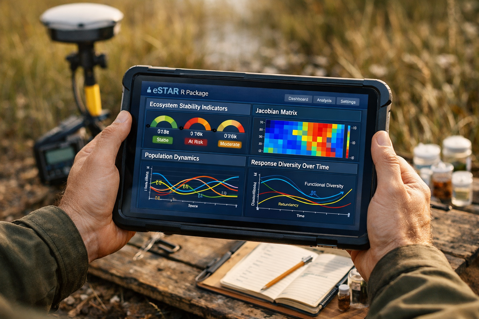
Jacobian Matrix Approaches for Community Stability
One of the estar package's most sophisticated features uses Jacobian matrices to measure community stability on both short and long time scales.[3] This mathematical approach maps multidimensional matrices representing species interaction strengths, enabling surveyors to assess whether a community structure is inherently stable or vulnerable to collapse.
In practical terms, this means surveyors can:
- Predict stability without waiting decades for empirical confirmation
- Identify vulnerable communities that appear superficially healthy but have unstable interaction structures
- Evaluate restoration success by comparing Jacobian eigenvalues before and after intervention
- Prioritize conservation efforts toward communities with stable configurations worth preserving
The mathematical rigor of Jacobian approaches provides the defensibility increasingly required for BNG verification and compliance, particularly when developers or regulators question assessment conclusions.
Integration with Remote Sensing Time Series
Frontiers' active research topic on "Multi-source remote sensing time series for monitoring land surface dynamics" directly addresses scalability challenges facing biodiversity surveyors in 2026.[1][4] Ground-based surveys remain essential for species-level detail, but remote sensing integration enables:
- Landscape-scale context for site-specific assessments
- Temporal frequency impossible with field visits alone
- Vegetation structure metrics (NDVI, LAI, canopy height) correlated with habitat quality
- Change detection identifying areas requiring targeted ground-truthing
The most effective 2026 protocols combine high-resolution satellite imagery, drone-based multispectral surveys, and strategic ground sampling in an integrated framework. This multi-source approach aligns with Frontiers research emphasizing that no single data source captures ecosystem dynamics completely.[4]
For surveyors working on off-site BNG delivery, remote sensing provides cost-effective monitoring of dispersed habitat creation sites, with ground surveys strategically deployed to validate remote-sensed condition assessments.
Implementing Frontiers 2026 Ecosystem Dynamics: Essential Survey Protocols in UK BNG Context
Scalable Methods for Post-2026 Policy Requirements
The UK's mandatory BNG requirements, now fully implemented for most development types, demand verification methods that are both scientifically rigorous and economically feasible at scale. Frontiers 2026 Ecosystem Dynamics: Essential Survey Protocols for Biodiversity Surveyors from Latest Research Topics directly address this challenge by providing frameworks that scale from individual sites to landscape networks.
Key implementation strategies include:
Tiered Survey Intensity: Not all sites require identical effort. Use remote sensing and existing data for initial screening, deploying intensive ground surveys and stability modeling only where baseline uncertainty is high or ecological stakes are significant.
Standardized Stability Metrics: Adopt estar package indicators as standard reporting elements in BNG assessments, enabling comparison across projects and cumulative impact evaluation.
Temporal Sampling Protocols: Minimum three-season sampling for habitat condition assessment, with extended monitoring for sites where response diversity or stability trajectory is uncertain.
Context Documentation: Record concurrent environmental conditions (temperature, moisture, recent disturbance history) alongside biological data to enable context-dependent analysis.
These protocols align with the guidance for developers seeking defensible assessments that withstand regulatory scrutiny while remaining cost-proportionate.
Footprint Identification Technology Breakthrough
January 2026 brought a significant advancement for field surveyors: footprint identification technology capable of distinguishing ecosystem-critical species previously identifiable only through DNA analysis.[8] This breakthrough expands survey capabilities for elusive mammals and other taxa where direct observation is challenging.
The technology's implications for survey protocols include:
- ✅ Non-invasive monitoring of sensitive species without trapping or handling stress
- ✅ Presence confirmation for species lists without requiring visual sightings
- ✅ Individual identification enabling population estimation through mark-recapture mathematics
- ✅ Temporal activity patterns revealed through track timing analysis
For biodiversity surveyors working with developers, this technology reduces survey costs for species that previously required expensive DNA sampling while improving detection reliability.
Women in Ecosystem Dynamics: Expanding Research Perspectives
Frontiers' second edition of "Women in Population, Community and Ecosystem Dynamics" collection for 2026 highlights contributions from female researchers advancing the field.[6] This initiative addresses historical gender imbalances in ecology while bringing diverse perspectives to methodological development.
For the surveying profession, supporting diverse research communities ensures:
- Broader methodological innovation from varied professional experiences
- Improved field safety protocols addressing needs of all practitioners
- Enhanced community engagement in conservation projects through representative teams
- Mentorship pathways encouraging new professionals into biodiversity careers
The research topics emerging from this collection often emphasize practical applicability and stakeholder engagement—priorities highly relevant to commercial survey work supporting BNG implementation.
Advanced Protocol Components for 2026 Survey Standards
Multi-Trophic Assessment Requirements
The response diversity research emphasizes that stabilization mechanisms operate differently across trophic levels, requiring surveyors to assess multiple levels rather than focusing exclusively on charismatic species or vegetation.[2] Comprehensive 2026 protocols should include:
Primary Producers:
- Vascular plant species richness and abundance
- Functional diversity (growth forms, phenology, resource acquisition strategies)
- Productivity metrics (biomass, NDVI from remote sensing)
Primary Consumers:
- Invertebrate community sampling (pitfall traps, sweep netting, malaise traps)
- Herbivore abundance and diversity
- Pollinator surveys during flowering periods
Secondary Consumers:
- Predatory invertebrate and vertebrate surveys
- Bird and bat acoustic monitoring
- Mammal camera trapping and footprint identification
Decomposers:
- Soil invertebrate sampling
- Fungal diversity assessment
- Decomposition rate measurements
This multi-trophic approach captures the interaction networks that determine ecosystem stability, providing the data necessary for Jacobian matrix analysis and comprehensive stability assessment.
Temporal Resolution and Monitoring Frequency
Static single-visit surveys cannot capture the dynamic responses central to 2026 ecosystem understanding. Appropriate temporal resolution depends on assessment objectives:
Baseline Condition Assessment (pre-development):
- Minimum three seasonal visits capturing spring, summer, and autumn conditions
- Extended breeding bird survey (April-July with multiple visits)
- Invertebrate sampling across activity periods
- Vegetation surveys at peak flowering and post-senescence
Restoration Trajectory Monitoring (post-intervention):
- Annual assessments for minimum five years to calculate stability metrics
- Increased frequency (quarterly or biannual) in first two years when change is rapid
- Event-based sampling following disturbances (storms, droughts, management actions)
- Continuous remote sensing with annual ground-truthing
Long-term BNG Compliance Verification:
- Annual monitoring for 30-year habitat creation obligations
- Adaptive sampling intensity based on trajectory confidence
- Integration of automated monitoring (camera traps, acoustic recorders) reducing field visit costs
These temporal protocols enable calculation of the stability indicators in the estar package, transforming monitoring from simple species lists to quantitative stability assessment.[3]
Data Management and Reproducibility Standards
Frontiers journals emphasize open science and reproducibility—principles equally applicable to commercial survey work. Best practice 2026 protocols include:
- Structured data collection using standardized field forms or digital apps
- Metadata documentation recording survey effort, conditions, and methods
- Version-controlled analysis scripts (R, Python) enabling result reproduction
- Archived raw data in accessible formats (CSV, not proprietary)
- Transparent uncertainty quantification in all abundance and diversity estimates
For surveyors preparing BNG reports for planning applications, this transparency builds credibility with regulators and provides defensibility if assessments are challenged.
Practical Implementation Guidance for Survey Teams
Equipment and Technology Requirements
Implementing Frontiers 2026 Ecosystem Dynamics: Essential Survey Protocols for Biodiversity Surveyors from Latest Research Topics requires updated field equipment:
Essential Technology:
- Ruggedized tablets or smartphones with GPS for digital data collection
- R or Python installation for estar package analysis
- Drone with multispectral camera for site-scale habitat mapping (where legally permitted)
- Automated recording devices (AudioMoth for bats/birds, camera traps for mammals)
- Footprint identification reference materials and measurement tools
Traditional Equipment Remains Critical:
- Species identification guides and hand lenses
- Quadrats, transect tapes, and marking equipment
- Invertebrate sampling gear (nets, traps, aspirators)
- Soil sampling equipment for decomposer assessment
- Weather station or portable environmental sensors
The technology enhances rather than replaces traditional ecological field skills. Species identification expertise remains the irreplaceable foundation of quality survey work.
Training and Skill Development Priorities
Survey teams should prioritize developing competencies in:
- Quantitative ecology: Understanding stability metrics, interaction networks, and time series analysis
- R programming: Basic proficiency for using estar and related packages
- Remote sensing interpretation: Recognizing habitat types and conditions from imagery
- Statistical modeling: Moving beyond descriptive statistics to predictive models
- Adaptive management: Adjusting protocols based on emerging results and research
Professional development resources include Frontiers' open-access research articles, online R courses, and specialized training in emerging technologies like footprint identification.[1][8]
Quality Assurance and Validation
Robust protocols include built-in quality checks:
✓ Inter-observer calibration: Multiple surveyors independently assess the same plots to quantify consistency
✓ Voucher specimens: Physical or photographic specimens documenting identification decisions
✓ Statistical power analysis: Ensuring sample sizes adequate for detecting meaningful differences
✓ Peer review: Internal technical review before report finalization
✓ Ground-truthing: Field validation of remote sensing classifications
These quality measures ensure survey results meet the scientific rigor expected in 2026 regulatory contexts and align with Frontiers' publication standards for ecological research.[7]
Addressing Common Implementation Challenges
Cost-Effectiveness Concerns
Enhanced protocols inevitably raise cost concerns, particularly for small development projects. Cost management strategies include:
- Risk-proportionate intensity: Simple sites with low ecological value receive streamlined assessments
- Technology efficiency gains: Automated monitoring reduces field visit costs for long-term programs
- Regional data sharing: Pooled baseline data reducing site-specific sampling needs
- Tiered reporting: Standard assessments with optional advanced stability analysis for complex cases
The estar package's open-source nature eliminates software licensing costs, democratizing access to sophisticated analytical tools.[3]
Regulatory Acceptance and Standardization
New methods face adoption barriers until regulatory bodies formally recognize them. Strategies for facilitating acceptance include:
- Supplementary reporting: Include traditional metrics alongside new stability indicators
- Pilot projects: Demonstrate methods on willing client projects before broader application
- Engagement with regulators: Proactive dialogue explaining scientific basis and benefits
- Publication in peer-reviewed literature: Building evidence base for method validity
As Frontiers research topics continue generating peer-reviewed evidence for these approaches, regulatory acceptance will accelerate.[1][5]
Data Gaps and Legacy Survey Integration
Many sites have historical survey data collected under older protocols. Integration strategies include:
- Metadata analysis: Determining what historical data can contribute to stability assessment
- Targeted supplementary sampling: Filling specific gaps in historical datasets
- Conservative uncertainty bounds: Acknowledging limitations when historical data is incomplete
- Prospective protocol adoption: Implementing new standards for future monitoring even when historical data differs
The goal is forward progress rather than perfect consistency with historical approaches that pre-date current scientific understanding.
Future Directions and Emerging Research
Frontiers Research Topics Shaping Next-Generation Protocols
Active Frontiers research topics for 2026 signal where survey protocols will evolve next:[1]
Ecology and Sustainability Strategies: This research topic explores integrating ecological science with sustainability frameworks, directly relevant to demonstrating how BNG contributes to broader environmental goals beyond site-specific metrics.[5]
Multi-Source Remote Sensing: Continued advancement in satellite, aerial, and ground-based sensing will enable even more comprehensive landscape-scale monitoring with reduced field effort.[4]
Population and Community Dynamics: Ongoing research into demographic processes and community assembly will refine understanding of which survey metrics best predict long-term ecosystem trajectories.[6]
Surveyors should monitor these research topics for emerging methods worth incorporating into evolving protocols.
Integration with Nature Recovery Networks
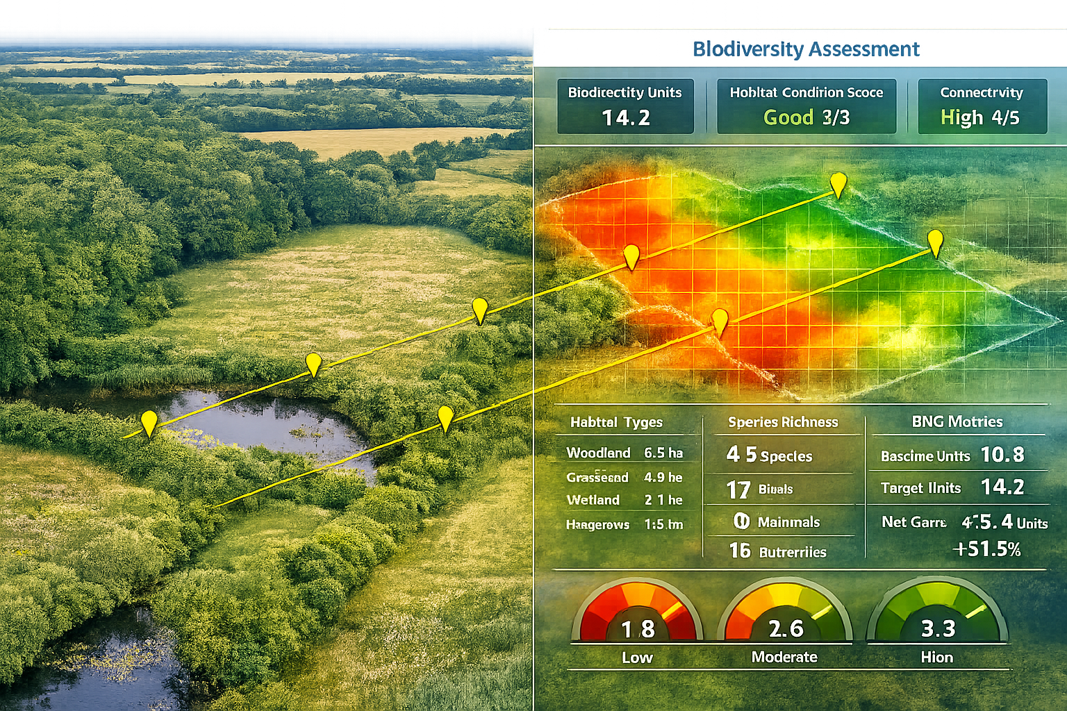
UK policy increasingly emphasizes landscape-scale conservation through Nature Recovery Networks. Survey protocols must evolve to assess:
- Connectivity metrics: Habitat patch isolation and corridor functionality
- Network-level biodiversity: Species pools across multiple sites
- Cumulative effects: Combined impacts of multiple developments on regional ecosystems
- Complementarity: How individual BNG sites contribute to network-wide objectives
These landscape perspectives require coordination among survey teams working on different projects within regions—a shift from traditional site-by-site independence.
Artificial Intelligence and Automated Species Identification
Machine learning for automated species identification from images and acoustic recordings continues advancing rapidly. While not yet reliable enough to replace expert identification, AI tools increasingly assist surveyors by:
- Pre-sorting images for expert review
- Flagging unusual or rare species for careful verification
- Enabling citizen science contributions to monitoring programs
- Processing large acoustic datasets impossible to analyze manually
As these tools mature, they'll further enhance survey efficiency while maintaining quality through expert oversight.
Conclusion
Frontiers 2026 Ecosystem Dynamics: Essential Survey Protocols for Biodiversity Surveyors from Latest Research Topics represent a fundamental evolution in how ecological assessments are conducted. The March 2026 response diversity framework, estar package release, and ongoing Frontiers research topics provide biodiversity surveyors with scientifically rigorous, scalable methods that align with both cutting-edge ecology and practical regulatory requirements.
The shift from static, equilibrium-based assessments to dynamic, context-dependent protocols captures ecosystem reality more accurately. For professionals conducting biodiversity assessments supporting BNG compliance, these enhanced methods offer:
- Greater scientific defensibility when assessments are scrutinized
- Improved prediction of restoration trajectory and success likelihood
- Standardized metrics enabling comparison across projects and regions
- Cost-effective scalability through technology integration and tiered intensity
Actionable Next Steps for Survey Practitioners
- Install and explore the estar R package: Familiarize yourself with stability indicators and data requirements before field season
- Review Frontiers research topics: Identify emerging methods relevant to your typical project types
- Pilot new protocols on willing projects: Test enhanced approaches on suitable sites before widespread adoption
- Invest in technology: Acquire drones, automated recorders, or footprint identification resources appropriate to your practice
- Engage with regulatory bodies: Discuss new methods proactively to facilitate acceptance
- Pursue continuing education: Develop quantitative ecology and programming skills through online courses
- Collaborate regionally: Share baseline data and coordinate monitoring with other practitioners
The biodiversity surveying profession stands at an inflection point where scientific advancement and policy requirements converge. Those who embrace Frontiers 2026 Ecosystem Dynamics: Essential Survey Protocols will deliver superior assessments that better serve both ecological outcomes and client needs in an increasingly demanding regulatory environment.
For surveyors committed to excellence, the path forward is clear: integrate the latest research, adopt standardized analytical tools, embrace dynamic ecosystem perspectives, and maintain the field expertise that remains irreplaceable. The result will be assessments that truly capture ecosystem health and trajectory—the ultimate goal of biodiversity survey work.
References
[1] Research Topics – https://www.frontiersin.org/journals/ecology-and-evolution/research-topics
[2] pubmed.ncbi.nlm.nih.gov – https://pubmed.ncbi.nlm.nih.gov/41844613/
[3] 2026 03 Software Biodiversity Enables Comprehensive Quantification – https://phys.org/news/2026-03-software-biodiversity-enables-comprehensive-quantification.html
[4] Multi Source Remote Sensing Time Series For Monitoring Land Surface Dynamics And Environmental Changeundefined – https://www.frontiersin.org/research-topics/79235/multi-source-remote-sensing-time-series-for-monitoring-land-surface-dynamics-and-environmental-changeundefined
[5] Ecology And Sustainability Strategies For Meeting The Challenges Of The Third Millenniumundefined – https://www.frontiersin.org/research-topics/73931/ecology-and-sustainability-strategies-for-meeting-the-challenges-of-the-third-millenniumundefined
[6] Impact – https://www.frontiersin.org/research-topics/78144/women-in-population-community-and-ecosystem-dynamics-2026/impact
[7] Author Guidelines Fee – https://esajournals.onlinelibrary.wiley.com/hub/journal/15409309/resources/author-guidelines-fee
[8] Frontiers In Ecology And Evolution – https://www.frontiersin.org/news/tag/frontiers-in-ecology-and-evolution
