
Rural settlements cause 3.5 times more biodiversity loss than cities [4]. This startling statistic reveals a hidden crisis: while urban sprawl captures headlines, the quiet expansion of low-density rural development and associated road networks is silently fragmenting habitats at unprecedented rates. Between 2000 and 2020, rural settlements expanded into 2.3 times more natural and semi-natural habitat than urban areas [4], creating a complex web of barriers that isolate wildlife populations and accelerate species decline.
For ecologists working on Biodiversity Net Gain (BNG) projects in 2026, understanding the Rural Roads Impact on Biodiversity: Survey Protocols for Ecologists Mitigating Habitat Fragmentation in BNG Projects has become essential. As vertebrate populations have declined 69% since 1970 [3], and approximately one million species face extinction risk [3], the need for standardized assessment methods and effective mitigation strategies has never been more urgent.
Key Takeaways
- Rural road networks fragment habitats 3.5 times more severely than urban development, requiring specialized survey protocols to quantify ecological impacts accurately
- Standardized biodiversity corridor identification methodologies enable ecologists to pinpoint critical areas where roads pose the greatest threat to species movement and genetic connectivity
- Endemic species with restricted ranges receive highest priority in mitigation planning, with survey protocols focusing on traffic mortality, barrier effects, and population isolation
- Effective BNG strategies integrate wildlife crossing structures, habitat connectivity restoration, and long-term monitoring to achieve measurable net gain outcomes
- Asia accounts for over half of global settlement-linked biodiversity loss, making regional adaptation of survey protocols essential for international projects
Understanding Rural Roads Impact on Biodiversity and Habitat Fragmentation
The Scale of the Problem
Roads act as impenetrable barriers to animal movement while introducing significant noise and chemical pollution [2]. The transportation network's documented landscape fragmentation effects facilitate deeper human encroachment into wild areas, creating cascading ecological impacts that extend far beyond the road surface itself.
Road construction decreases terrain permeability, causes direct habitat loss, and exacerbates habitat fragmentation by impeding interior species through disruption of horizontal biological fluxes and alteration of landscape spatial layout [1]. Wildlife face habitat isolation, traffic mortality, and stress from noise and artificial lighting, which collectively reduce gene flow and long-term population viability [5].
Regional Variations in Impact
The biodiversity crisis driven by rural road expansion shows distinct geographic patterns:
- Asia accounts for more than half of global settlement-linked biodiversity loss [4]
- Expansion within Key Biodiversity Areas (KBAs) was 3.7 times faster for rural settlements than urban ones [4]
- Sub-Saharan Africa and Southeast Asia demonstrate particularly high vulnerability due to endemic species concentrations
Understanding these regional variations helps ecologists prioritize survey efforts and tailor mitigation strategies to local ecological contexts. When planning your BNG project, recognizing the specific threats posed by rural infrastructure in your region is the critical first step.
Mechanisms of Biodiversity Loss
Rural roads impact biodiversity through multiple interconnected mechanisms:
🔴 Direct mortality – Vehicle strikes affecting mammals, amphibians, reptiles, and birds
🟠 Barrier effects – Physical and behavioral impediments to movement reducing genetic connectivity
🟡 Edge effects – Altered microclimates, invasive species colonization, and predator access along road margins
🟢 Pollution impacts – Chemical runoff, noise disturbance, and artificial lighting disrupting behavior and physiology
🔵 Hydrological disruption – Altered water flow patterns affecting aquatic and wetland species
Survey Protocols for Ecologists: Quantifying Road Impacts in BNG Projects
Baseline Biodiversity Assessment Methods
Effective biodiversity impact assessment for rural road projects requires comprehensive baseline surveys that capture both direct and indirect impacts. Ecologists should implement the following standardized protocols:
Phase 1: Desktop Assessment
- Review existing species records within 2km of proposed road alignment
- Identify designated sites (SSSIs, Local Wildlife Sites, Key Biodiversity Areas)
- Map habitat connectivity using GIS analysis
- Review historic aerial imagery to assess landscape change
- Consult local ecological records centers and conservation organizations
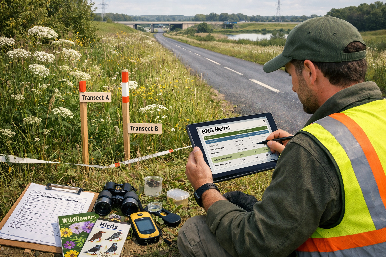
Phase 2: Field Survey Design
- Establish survey transects perpendicular to road alignment at 200m intervals
- Position camera traps at potential crossing points to document wildlife movement patterns
- Conduct seasonal surveys covering breeding, migration, and hibernation periods
- Record baseline noise levels and light pollution measurements
- Document existing road mortality through systematic carcass surveys
Phase 3: Species-Specific Protocols
| Species Group | Survey Method | Optimal Timing | Key Metrics |
|---|---|---|---|
| Mammals | Camera traps, track surveys, hair tubes | Year-round, focus on breeding season | Movement frequency, crossing attempts, mortality rates |
| Amphibians | Visual encounter surveys, pitfall traps | Spring migration (Feb-May) | Population size, migration routes, road mortality |
| Birds | Point counts, territory mapping | Breeding season (Apr-Jul) | Territory density, nest site proximity, flight patterns |
| Invertebrates | Sweep netting, pitfall traps, light traps | Apr-Sep (weather dependent) | Species richness, abundance, habitat specialist presence |
| Bats | Acoustic surveys, roost inspections | May-Sep (activity season) | Commuting routes, foraging areas, crossing heights |
Biodiversity Corridor Identification Framework
A scalable biodiversity corridor identification methodology has been developed that overlays high-resolution species distribution maps with national road networks to identify biodiversity-critical corridors [3]. This framework provides ecologists with a systematic approach to prioritizing mitigation efforts.
Endemic species with small geographic ranges receive highest priority protection [3], as they are most vulnerable to habitat loss. The framework classifies species into four priority groups:
- Priority 1: Endemic species with occurrence regions <10,000 km²
- Priority 2: Endemic species with occurrence regions 10,000-50,000 km²
- Priority 3: Non-endemic species with restricted ranges
- Priority 4: Widespread generalist species
Biodiversity-critical corridors are typically limited in number and spatially concentrated [3], making protection efforts cost-effective when focused on these critical areas rather than diffused across landscapes. When creating a biodiversity plan, this prioritization framework ensures resources target the most ecologically significant areas.
Quantifying Fragmentation Metrics
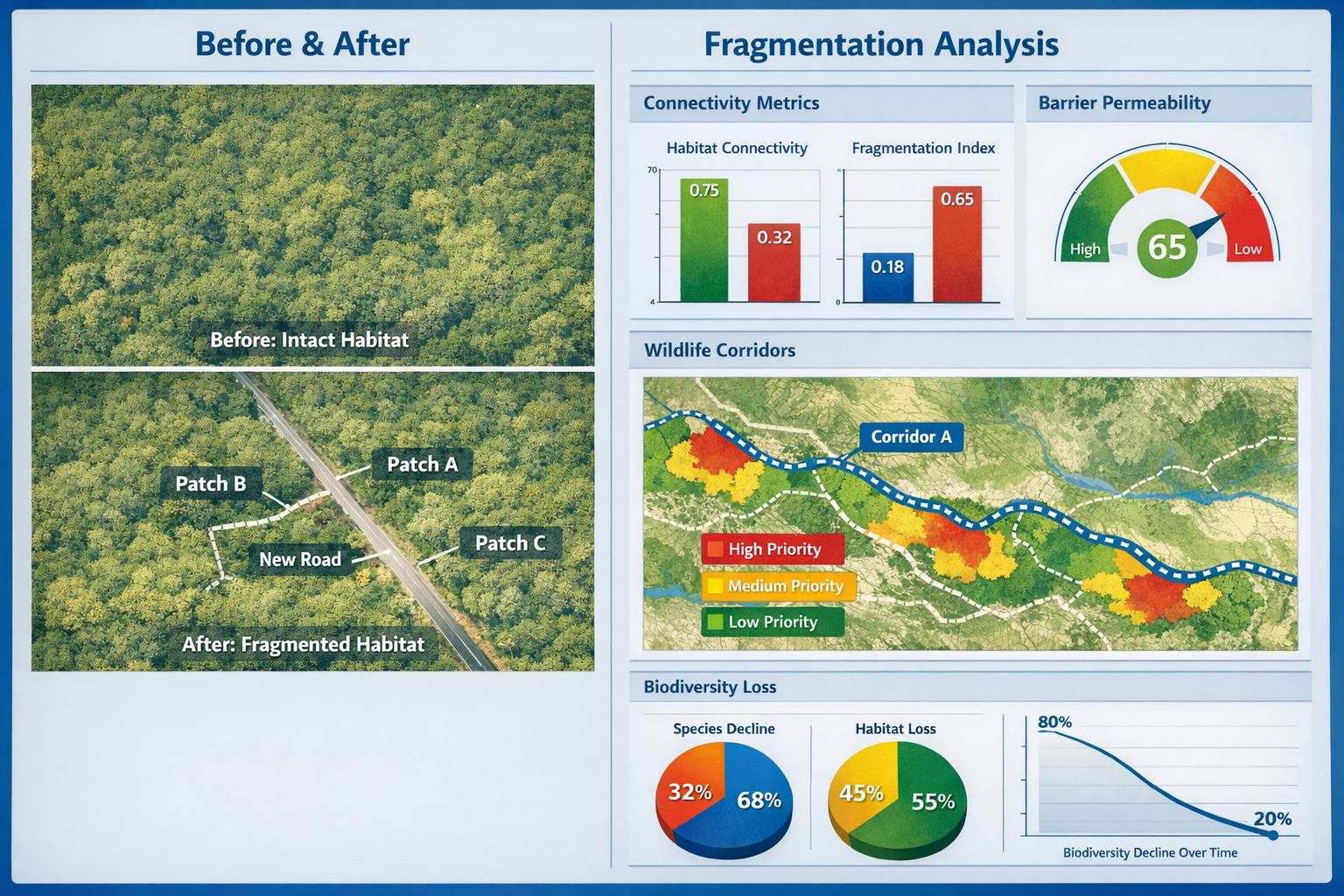
Ecologists must quantify habitat fragmentation using standardized metrics that can be integrated into BNG calculations:
Connectivity Metrics:
- Patch Cohesion Index – Measures physical connectedness of habitat patches
- Effective Mesh Size – Calculates probability that two randomly chosen points are connected
- Landscape Division Index – Quantifies degree of landscape fragmentation by barriers
Barrier Permeability Scores:
- Traffic volume and speed assessments
- Road width and surface type documentation
- Presence/absence of existing crossing structures
- Vegetation continuity across road corridor
Population Viability Indicators:
- Genetic diversity sampling (where feasible)
- Population density estimates in fragmented vs. continuous habitat
- Demographic structure analysis
- Movement tracking data (GPS collaring, PIT tagging)
These quantitative assessments provide the evidence base for biodiversity net gain assessments and ensure mitigation measures are proportionate to impacts.
Mitigation Strategies for Achieving Biodiversity Net Gain
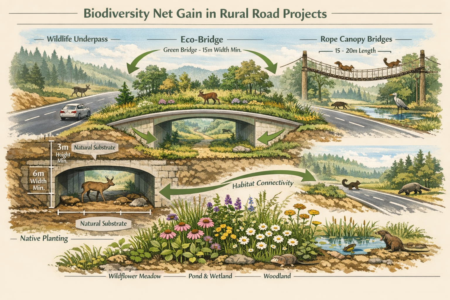
Wildlife Crossing Infrastructure
Properly designed wildlife crossing structures represent the most effective mitigation for road barrier effects. Ecologists must specify crossing designs based on target species requirements:
Underpass Structures:
- Large mammal underpasses (>4m width) with natural substrate and vegetation screening
- Small mammal tunnels (0.3-0.6m diameter) with dry ledges for amphibians
- Multi-use underpasses accommodating diverse species guilds
Overpass Structures:
- Green bridges with native vegetation and soil depths supporting typical habitat structure
- Canopy bridges (rope or pole designs) for arboreal mammals and invertebrates
- Glider poles for species with limited flight capability
Design Considerations:
- Approach habitat quality and continuity
- Appropriate dimensions for target species (length:width ratios)
- Substrate type and vegetation establishment
- Lighting restrictions to avoid deterring nocturnal species
- Fencing to guide wildlife toward crossing structures
Habitat Connectivity Enhancement
Beyond crossing structures, comprehensive mitigation requires landscape-scale connectivity enhancement:
✅ Hedgerow restoration creating continuous habitat corridors parallel to roads
✅ Riparian buffer enhancement maintaining aquatic connectivity under road crossings
✅ Stepping stone habitats reducing isolation distances between major habitat patches
✅ Road verge management using native species mixes and reduced mowing regimes
✅ Lighting design minimizing light spill into adjacent habitats
For small development projects where on-site mitigation space is limited, these landscape-scale approaches become particularly important.
Off-Site Compensation and Habitat Banking
When on-site mitigation cannot fully offset impacts, off-site biodiversity net gain delivery becomes necessary. Rural road projects often require off-site compensation due to:
- Linear infrastructure geometry limiting on-site habitat creation
- Site constraints preventing adequate connectivity restoration
- Need for compensation in ecologically equivalent locations
Ecologists should evaluate off-site options using these criteria:
Spatial Proximity:
- Within same National Character Area or local planning authority boundary
- Connected to impacted habitat networks
- Accessible to displaced populations
Ecological Equivalence:
- Matching habitat types and condition states
- Supporting similar species assemblages
- Appropriate soil, hydrology, and microclimate conditions
Additionality and Deliverability:
- Genuine biodiversity gain beyond existing baseline
- Secure long-term management (minimum 30 years)
- Realistic establishment timescales with contingency planning
Understanding land banking vs. habitat banking options helps developers select appropriate off-site strategies for their specific project context.
Monitoring and Adaptive Management Protocols
Long-Term Effectiveness Monitoring
BNG commitments require demonstrable outcomes over 30-year timescales. Ecologists must establish monitoring protocols that track:
Structural Indicators:
- Habitat establishment success rates
- Vegetation composition and structure development
- Crossing structure usage frequency (camera trap data)
- Barrier permeability improvements
Functional Indicators:
- Population trends in target species
- Genetic connectivity maintenance (molecular analysis)
- Species richness and community composition changes
- Ecosystem function recovery (pollination, seed dispersal)
Monitoring Schedule:
| Year | Monitoring Intensity | Key Metrics |
|---|---|---|
| 1-3 | Annual comprehensive surveys | Establishment success, initial colonization |
| 4-10 | Biennial targeted surveys | Population trends, crossing usage |
| 11-30 | Five-yearly comprehensive surveys | Long-term trajectory, condition maintenance |
Adaptive Management Triggers
Monitoring data should inform adaptive management responses when outcomes deviate from predictions:
🔄 Trigger 1: Crossing structure under-utilization (<50% predicted usage)
- Response: Enhance approach habitat, adjust fencing, modify structure design
🔄 Trigger 2: Persistent road mortality hotspots (>10 casualties/year)
- Response: Install additional crossing structures, improve barrier fencing, implement traffic calming
🔄 Trigger 3: Habitat creation below target condition (<Good condition after 5 years)
- Response: Adjust management prescriptions, supplementary planting, invasive species control
🔄 Trigger 4: Population decline in target species (>25% reduction)
- Response: Investigate limiting factors, enhance habitat quality, improve connectivity
This adaptive approach ensures achieving biodiversity net gain without the risk of failed mitigation strategies.
Case Study Applications and Lessons Learned
Philippines Road Network Assessment
Case studies from the Philippines demonstrate the effectiveness of systematic corridor identification [3]. By overlaying high-resolution species distribution maps with national road networks, ecologists identified 47 biodiversity-critical corridors where road expansion posed significant risks to endemic species.
Key Findings:
- 78% of critical corridors affected endemic amphibians and reptiles
- Targeted mitigation at these 47 locations protected 156 endemic species
- Cost-effectiveness improved 12-fold compared to diffused mitigation approaches
Sub-Saharan Africa Infrastructure Planning
Similar methodologies applied in Sub-Saharan Africa revealed that biodiversity-critical corridors represented only 8% of total road network length but affected 64% of endemic mammal species [3].
Implementation Outcomes:
- Early-stage route optimization avoided 23 critical corridors
- Remaining unavoidable impacts addressed through targeted crossing structures
- Monitoring demonstrated 85% effectiveness in maintaining connectivity after 5 years
These international examples demonstrate that Rural Roads Impact on Biodiversity: Survey Protocols for Ecologists Mitigating Habitat Fragmentation in BNG Projects must be adapted to regional ecological contexts while maintaining standardized quantitative approaches.
Integration with UK BNG Policy Framework
Statutory Requirements
In 2026, UK BNG legislation requires all development projects (with limited exemptions) to demonstrate 10% net gain. Rural road projects must:
- Complete baseline biodiversity assessments using Defra Metric 4.0
- Quantify habitat fragmentation impacts on connectivity
- Demonstrate net gain through combination of on-site and off-site measures
- Secure 30-year management and monitoring commitments
- Register gains on national biodiversity gain sites register
For detailed guidance on achieving these requirements, review how to achieve 10% biodiversity net gain.
Metric Considerations for Linear Infrastructure
The Defra Metric presents specific challenges for linear infrastructure:
Spatial Risk Multipliers:
- Off-site compensation incurs spatial risk penalties
- Connectivity losses difficult to quantify in standard habitat units
- Temporal delays in habitat establishment reduce net gain calculations
Strategic Solutions:
- Prioritize on-site connectivity enhancement where feasible
- Select off-site locations within same ecological network
- Use advanced habitat creation techniques to accelerate establishment
- Consider purchasing biodiversity units from established habitat banks to reduce temporal risk
Emerging Technologies and Future Directions
Remote Sensing Applications
Advances in remote sensing technology are revolutionizing biodiversity surveys for rural road projects:
LiDAR Analysis:
- High-resolution vegetation structure mapping
- Identification of wildlife movement corridors
- Baseline habitat condition assessment
Drone-Based Surveys:
- Rapid baseline documentation across large linear sites
- Thermal imaging for mammal detection
- Repeat photography for monitoring habitat establishment
Satellite Imagery:
- Landscape-scale connectivity analysis
- Change detection monitoring
- Regional biodiversity loss tracking
Environmental DNA (eDNA) Techniques
eDNA sampling provides cost-effective species detection:
- Water sampling for aquatic and amphibian species presence
- Soil sampling for terrestrial species detection
- Non-invasive monitoring reducing survey effort
- Early detection of colonization success in created habitats
Artificial Intelligence and Machine Learning
AI applications are enhancing survey efficiency and accuracy:
- Automated species identification from camera trap images
- Acoustic monitoring analysis for bats and birds
- Predictive modeling of connectivity requirements
- Optimization algorithms for crossing structure placement
Conclusion
The Rural Roads Impact on Biodiversity: Survey Protocols for Ecologists Mitigating Habitat Fragmentation in BNG Projects represents a critical frontier in conservation practice. With rural settlements causing 3.5 times more biodiversity loss than cities [4], and road networks fragmenting habitats at unprecedented rates, standardized survey protocols and effective mitigation strategies are essential for reversing species decline.
Ecologists working on BNG projects must adopt comprehensive approaches that:
✓ Quantify impacts using standardized fragmentation metrics and species-specific surveys
✓ Prioritize mitigation focusing on biodiversity-critical corridors and endemic species
✓ Design effective solutions integrating crossing structures with landscape-scale connectivity enhancement
✓ Monitor outcomes through long-term adaptive management ensuring genuine net gain
✓ Leverage technology utilizing remote sensing, eDNA, and AI to improve efficiency and accuracy
Next Steps for Practitioners
For Ecologists:
- Implement the survey protocols outlined in this guide on your next rural road project
- Engage with regional ecological records centers to access baseline data
- Collaborate with engineers early in design stages to optimize route selection
- Develop monitoring plans that track both structural and functional indicators
For Developers:
- Commission comprehensive baseline surveys at project inception
- Budget adequately for both mitigation infrastructure and long-term monitoring
- Consider biodiversity net gain reports as strategic planning tools, not compliance paperwork
- Explore off-site options early if on-site mitigation proves insufficient
For Planners:
- Request evidence of corridor identification analysis in planning applications
- Scrutinize proposed mitigation for species-specific design appropriateness
- Ensure monitoring and adaptive management commitments are enforceable
- Coordinate with neighboring authorities on landscape-scale connectivity planning
The biodiversity crisis demands urgent action, but the tools and methodologies now exist to ensure rural road development contributes to nature recovery rather than continued decline. By implementing rigorous survey protocols and evidence-based mitigation strategies, ecologists can transform infrastructure projects from threats into opportunities for landscape-scale habitat connectivity enhancement.
The future of biodiversity in rural landscapes depends on our collective commitment to standardized, scientifically robust approaches to impact assessment and mitigation. As we expand rural infrastructure to meet societal needs, we must simultaneously expand our capacity to protect and enhance the ecological networks that sustain life on Earth.
References
[1] Sustainable Biodiversity – https://sustainable-biodiversity.com/index.php/pub/article/view/71
[2] Rural Expansion Drives Biodiversity Loss – https://www.intelligentliving.co/rural-expansion-drives-biodiversity-loss/
[3] Smart Roads Transforming Road Investments With Biodiversity Int – https://blogs.worldbank.org/en/developmenttalk/smart-roads–transforming-road-investments-with-biodiversity-int
[4] Rural Expansion Is Driving More Biodiversity Loss Than Cities Global Study Finds – https://www.downtoearth.org.in/urbanisation/rural-expansion-is-driving-more-biodiversity-loss-than-cities-global-study-finds
[5] Conservation In The Path Of Development New Data To Guide Road – https://blogs.worldbank.org/en/opendata/conservation-in-the-path-of-development–new-data-to-guide-road-
