
Recent GIS research mapping pollinator movement across New York City revealed a startling finding: 86% of direct paths between parks are blocked by buildings, forcing pollinators to navigate routes averaging 20% longer than straight-line distances.[2] This discovery underscores a critical challenge facing urban biodiversity professionals in 2026—designing effective survey protocols that capture the complex reality of pollinator movement through fragmented cityscapes. As cities worldwide implement Biodiversity Net Gain (BNG) requirements, understanding Urban Pollinator Corridors in Biodiversity Surveys: Protocols for City Ecology Surveyors has become essential for developers, planners, and conservation professionals working to create functional ecological networks within built environments.
Urban pollinator corridors represent more than isolated green spaces—they function as interconnected pathways that enable bees, butterflies, and other essential pollinators to move between habitat patches, access diverse floral resources, and maintain genetic diversity across fragmented landscapes. For city ecology surveyors, documenting these corridors requires specialized protocols that account for green roofs, linear parks, planted medians, and even weedy remnants that collectively form the urban pollinator network.[5]

Key Takeaways
- 86% of urban pollinator paths are obstructed by buildings, requiring surveyors to map actual flight routes rather than straight-line distances between habitat patches[2]
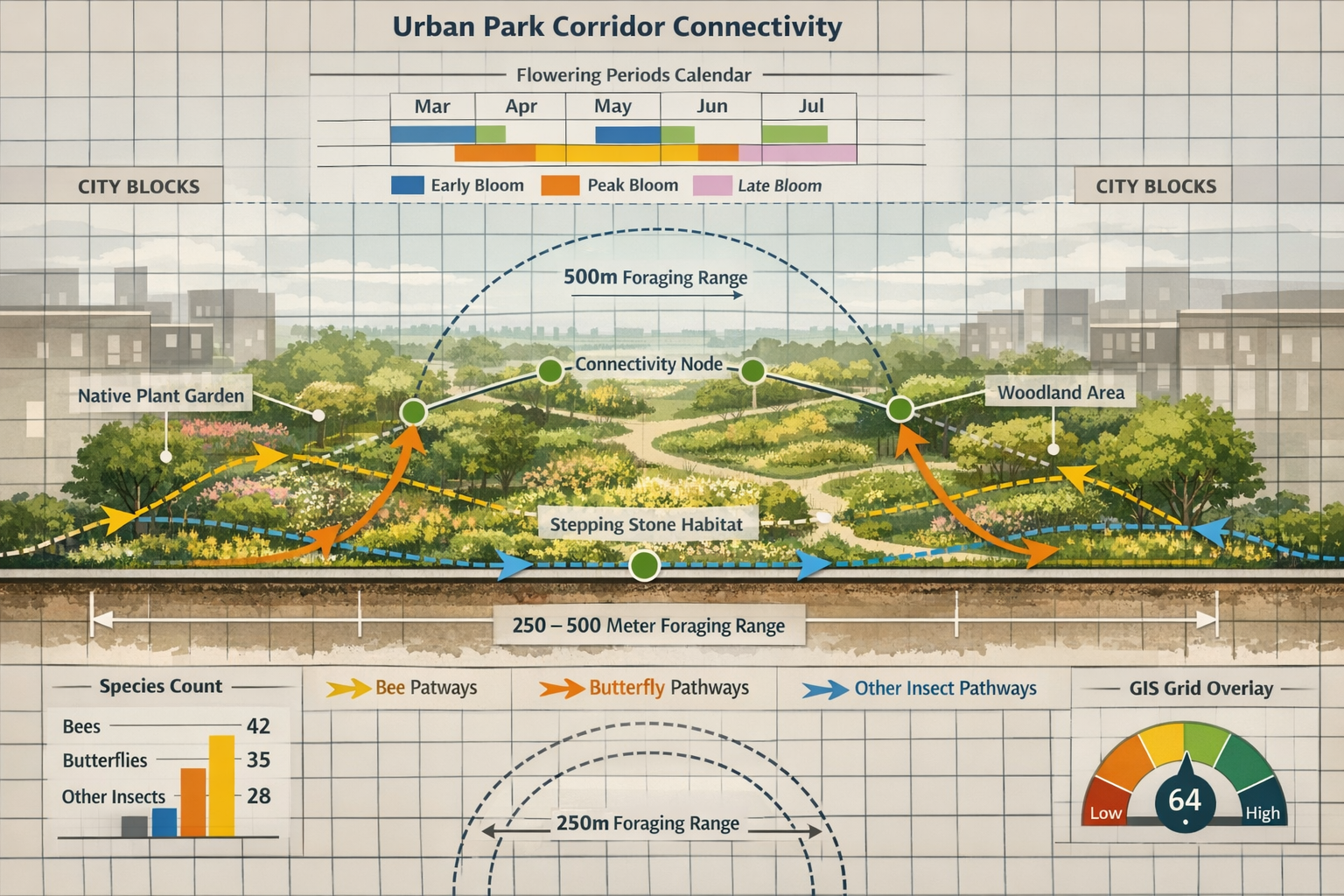
- Green roofs and linear parks serve as critical stepping stones in fragmented cities, with successful corridors requiring native plants, diverse flowering times, and connectivity within 250-500 meter foraging distances[1]
- Citizen science applications enable scalable data collection across urban landscapes, allowing surveyors to document pollinator abundance and movement patterns efficiently in 2026
- Earth Observation tools and open-source GIS provide cost-effective methods for mapping habitat heterogeneity and tracking ecological indicators consistently across regions[4]
- Integrated survey protocols that combine traditional field methods with modern technology support BNG compliance and create measurable biodiversity outcomes for urban developments
Understanding Urban Pollinator Corridors in Biodiversity Survey Design
Urban pollinator corridors function as wildlife highways through cities, connecting larger habitat areas through a network of smaller green spaces. Unlike rural corridors that may follow continuous natural features, urban corridors operate as stepping stones—discrete habitat patches positioned strategically to allow pollinators to move between disturbed environments.[5]
The Science Behind Urban Corridor Functionality
Research demonstrates that pollinator corridors must address specific biological requirements:
Critical Distance Thresholds 🐝
The NYC connectivity study revealed that foraging distances of 250-500 meters are particularly limited in highly built environments, indicating that solitary bee species and other pollinators with small movement capacities struggle to navigate between habitat patches.[2] This finding has profound implications for survey design—surveyors must map not just habitat quality within individual sites, but also the functional connectivity between sites.
Habitat Composition Requirements
Studies by University of Tartu entomologists demonstrated that linear pollinator corridors along highways in Ireland support 42 butterfly species and 22 bumblebee species, proving that infrastructure corridors can function as effective habitat when properly managed.[3] Successful corridors require:
- Native plant species appropriate to the local bioregion
- Diverse flowering times providing continuous nectar and pollen resources
- Physical connectivity between habitat patches
- Safe areas free from pesticides and intensive management
- Structural diversity including ground-nesting sites and overwintering habitat[1]
Urban Habitat Types in Corridor Networks
City ecology surveyors must recognize and document multiple habitat types that collectively form pollinator corridors:
| Habitat Type | Corridor Function | Survey Considerations |
|---|---|---|
| Green Roofs | Elevated stepping stones | Substrate depth, plant establishment, irrigation systems |
| Linear Parks | Primary movement corridors | Width, length, connectivity to other green spaces |
| Planted Medians | Narrow connectors | Traffic pollution impacts, maintenance regimes |
| Home Gardens | Distributed resources | Private access limitations, variable management |
| Rooftop Gardens | Vertical connectivity | Height above ground, species composition |
| Weedy Remnants | Spontaneous habitat | Succession stage, disturbance frequency |
When conducting biodiversity impact assessments for urban developments, surveyors must evaluate how proposed projects will affect connectivity between these diverse habitat types, not just the habitat value of individual sites.
Protocols for Surveying Green Roofs and Linear Parks
As urban development intensifies, green roofs and linear parks have emerged as critical components of pollinator corridor networks. Surveying these specialized habitats requires adapted protocols that address their unique characteristics while supporting BNG compliance.
Green Roof Survey Methodology
Green roofs present unique survey challenges due to access restrictions, substrate limitations, and microclimatic conditions that differ substantially from ground-level habitats.
Pre-Survey Assessment
Before conducting field surveys, ecology surveyors should gather:
- Roof construction specifications (substrate depth, drainage systems)
- Planting plans and plant establishment records
- Maintenance schedules and management history
- Irrigation system details
- Structural load capacity documentation
Field Survey Protocol for Green Roofs
-
Vegetation Assessment 📊
- Document plant species composition and cover percentages
- Record flowering phenology and bloom density
- Assess plant health and establishment success
- Identify spontaneous colonization by native species
- Measure vegetation structural diversity (height classes, growth forms)
-
Pollinator Observation Surveys
- Conduct timed observation periods (minimum 20 minutes per survey point)
- Record pollinator species, abundance, and behavior
- Document flower visitation rates
- Note nesting sites and overwintering habitat
- Repeat surveys across flowering season (minimum 3 visits: spring, summer, late summer)
-
Connectivity Analysis
- Map distances to nearest green spaces
- Identify potential flight corridors to and from the roof
- Assess visibility and accessibility for pollinators
- Document barriers (tall buildings, hostile surfaces)
Substrate and Microclimate Considerations
Green roof substrate depth critically affects plant establishment and pollinator value. Extensive green roofs (substrate depth 50-150mm) support different plant communities than intensive green roofs (substrate >150mm). Surveyors should document:
- Substrate depth variations across the roof
- Moisture retention characteristics
- Temperature extremes and wind exposure
- Shade patterns from adjacent structures
Linear Park Corridor Surveys
Linear parks—including rail trails, utility corridors, and waterfront greenways—function as primary movement corridors through urban landscapes. Survey protocols must capture both habitat quality and corridor functionality.
Corridor Characterization Framework
Physical Dimensions
- Total corridor length and width measurements
- Continuity assessment (breaks, barriers, hostile sections)
- Edge effects and buffer zones
- Adjacent land use impacts
Habitat Quality Metrics 🌸
- Native plant species richness and abundance
- Flowering plant density per linear meter
- Seasonal bloom progression documentation
- Nesting substrate availability (bare ground, hollow stems, dead wood)
- Pesticide exposure risk assessment
Connectivity Evaluation
Using open-source GIS tools (QGIS, Python libraries), surveyors can map movement pathways between green spaces, making connectivity assessments adaptable for different cities.[2] The methodology includes:
- Mapping all green spaces within the study area
- Calculating Euclidean distances between habitat patches
- Identifying physical barriers (buildings, roads, hostile surfaces)
- Modeling actual flight paths accounting for obstacles
- Calculating effective corridor width and permeability
For developments seeking to achieve 10% Biodiversity Net Gain, linear park corridors offer significant opportunities for measurable biodiversity enhancement, particularly when designed to connect existing habitat patches.
Integrated Vegetation Management for Corridors
Infrastructure corridors including energy transmission lines can be managed selectively to create flower-rich mosaics that enhance pollinator abundance while reducing maintenance demands.[4] Survey protocols should document:
- Current vegetation management practices
- Opportunities for reduced mowing frequency
- Native plant establishment potential
- Invasive species management needs
- Compatibility with infrastructure safety requirements
This integrated approach benefits both biodiversity outcomes and operational efficiency, making it attractive for developers and infrastructure managers working within BNG frameworks. Understanding how Biodiversity Net Gain benefits both nature and developers helps position corridor enhancement as a win-win solution.
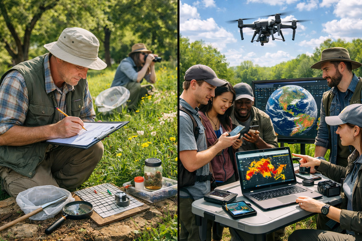
Citizen Science Applications for Scalable Urban Pollinator Monitoring
Traditional ecological surveys require specialized expertise and significant time investment, limiting the spatial and temporal coverage achievable within typical project budgets. Citizen science applications have emerged as powerful tools for scaling urban pollinator monitoring while maintaining data quality standards suitable for BNG compliance in 2026.
Technology-Enhanced Survey Protocols
Modern citizen science platforms integrate multiple technologies to enable non-specialists to contribute meaningful biodiversity data:
Mobile Application Features for 2026 Surveys
📱 iNaturalist and Specialized Pollinator Apps
- Photo-based species identification using AI algorithms
- GPS-tagged observation records
- Temporal data capture (date, time, weather conditions)
- Behavior documentation (foraging, nesting, mating)
- Community validation by expert reviewers
eBird and Pollinator-Specific Platforms
- Standardized survey protocols within apps
- Effort tracking (survey duration, area covered)
- Abundance estimation tools
- Habitat characterization templates
- Data export for analysis and reporting
Implementing Citizen Science in Professional Surveys
City ecology surveyors can integrate citizen science into professional survey protocols through structured approaches:
Hybrid Survey Design
-
Professional Baseline Assessment
- Conduct initial site characterization by qualified ecologists
- Establish survey points and protocols
- Create species reference guides for the site
- Train citizen science participants
-
Distributed Monitoring Network
- Deploy citizen scientists across multiple sites simultaneously
- Schedule coordinated observation periods
- Provide standardized data collection templates
- Maintain quality control through expert review
-
Professional Data Analysis and Reporting
- Validate citizen science observations
- Integrate professional and citizen data
- Conduct statistical analysis
- Prepare compliance documentation for BNG requirements
Quality Assurance Protocols ✅
To ensure citizen science data meets professional standards:
- Provide species identification training sessions
- Use photographic verification for all observations
- Implement expert review of submitted records
- Apply data filtering based on confidence levels
- Cross-reference with professional survey results
- Document data quality metrics in reports
Case Study: Washington DC Pollinator Pathway Project
Casey Trees received $499,816 from the National Fish and Wildlife Foundation's Chesapeake WILD Grant Program in March 2026 to create wildlife corridors in DC. Over three years, the project will plant 700 native trees and add 10,000 square feet of native plant gardens in areas east of Rock Creek Park, creating interconnected pollinator "cafes" linking Rock Creek Park, the National Arboretum, and Fort Dupont Park.[6]
This project demonstrates the stepping stone approach at city scale, with monitoring protocols incorporating:
- Professional ecological surveys at establishment
- Citizen science monitoring through mobile apps
- Community engagement in data collection
- Long-term tracking of pollinator abundance and diversity
- Adaptive management based on monitoring results
Earth Observation Tools for Habitat Mapping
Earth Observation tools can map habitat heterogeneity and floral resources, allowing ecological indicators to be tracked consistently across regions for pollinator abundance assessment.[4] These tools complement ground-based surveys by providing:
Satellite-Derived Metrics
- Vegetation indices (NDVI) tracking seasonal greenness
- Habitat patch size and distribution
- Landscape connectivity analysis
- Temporal change detection
- Urban heat island effects on habitat quality
Integration with Ground Surveys
Combining Earth Observation data with citizen science observations creates comprehensive monitoring systems that are:
- Scalable across large urban areas
- Cost-effective compared to intensive professional surveys
- Temporally continuous with regular satellite imagery
- Spatially explicit with precise location data
- Repeatable for long-term monitoring
For developers working on biodiversity plans for building projects, these integrated monitoring approaches provide robust evidence of biodiversity outcomes while controlling survey costs.
Data Management and Reporting for BNG Compliance
Survey data must be translated into actionable information that supports BNG compliance, planning decisions, and adaptive management. Effective data management protocols ensure survey efforts deliver maximum value.
Standardized Data Collection Templates
Field Data Requirements
Essential data fields for urban pollinator corridor surveys:
- Site Information: Location coordinates, habitat type, survey area dimensions
- Survey Conditions: Date, time, temperature, wind speed, cloud cover
- Observer Details: Surveyor name, qualifications, effort (time spent)
- Species Records: Species name, abundance, behavior, confidence level
- Habitat Characteristics: Vegetation composition, flowering density, structural features
- Connectivity Metrics: Distance to nearest habitats, barrier documentation
- Photographic Evidence: Geotagged images of habitat and species
Biodiversity Metric Calculation
Urban pollinator corridor surveys feed into BNG metric calculations that quantify biodiversity value. Key metrics include:
Habitat Distinctiveness
- Assess habitat quality against reference conditions
- Document native species composition
- Evaluate structural complexity
- Record management intensity
Habitat Condition
- Measure vegetation health and diversity
- Assess pollinator abundance relative to habitat potential
- Document disturbance factors
- Evaluate connectivity to other habitats
Strategic Significance
- Identify corridors connecting priority habitats
- Document rare or declining pollinator species
- Assess contribution to landscape-scale networks
- Evaluate climate resilience features
For professionals navigating Biodiversity Net Gain requirements, understanding how survey data translates into metric scores is essential for demonstrating compliance and optimizing design decisions.
Reporting Frameworks for Urban Developments
Professional Survey Reports Should Include:
-
Executive Summary
- Survey objectives and scope
- Key findings and recommendations
- BNG implications
-
Methodology Section
- Survey protocols and standards followed
- Limitations and constraints
- Quality assurance measures
-
Results and Analysis
- Species inventories with abundance data
- Habitat condition assessments
- Connectivity analysis with GIS maps
- Comparison to baseline or reference conditions
-
Biodiversity Metric Calculations
- Baseline biodiversity units
- Post-development predictions
- Net gain/loss calculations
- Enhancement recommendations
-
Management Recommendations
- Habitat creation and enhancement opportunities
- Corridor connectivity improvements
- Monitoring protocols for post-development
- Adaptive management triggers
Long-Term Monitoring Strategies
BNG requirements typically include monitoring commitments extending 30 years post-development. Efficient long-term monitoring protocols combine:
- Annual citizen science surveys for cost-effective data collection
- Periodic professional surveys (every 3-5 years) for quality assurance
- Remote sensing analysis for habitat extent and condition tracking
- Automated monitoring using camera traps or acoustic sensors where appropriate
When considering off-site versus on-site BNG delivery, long-term monitoring costs should factor into decision-making, with urban pollinator corridors often providing cost-effective monitoring opportunities through citizen science engagement.
Emerging Best Practices and 2026 Innovations
The field of urban pollinator corridor surveying continues to evolve rapidly, with 2026 bringing new tools, methodologies, and policy frameworks that shape professional practice.
State and Regional Programs
Utah Pollinator Habitat Program 2026
A statewide initiative launched to support landowners, organizations, and community groups in creating and enhancing native pollinator habitat through access to native plants and seed resources.[7] Such programs provide:
- Native plant material for corridor creation
- Technical assistance for habitat design
- Monitoring protocols and support
- Community engagement frameworks
City ecology surveyors can leverage these programs to enhance project outcomes and reduce establishment costs for corridor habitats.
Adaptive Survey Protocols
Seasonal Survey Timing 🗓️
Optimal survey timing varies by pollinator group and geographic region:
- Early Spring (March-May): Queen bumblebees, early solitary bees, spring butterflies
- Peak Summer (June-July): Maximum species diversity, peak flowering
- Late Summer (August-September): Late-season specialists, monarch migration
- Minimum Recommendation: Three survey visits spanning the growing season
Weather-Dependent Scheduling
Pollinator activity depends heavily on weather conditions. Survey protocols should specify:
- Minimum temperature thresholds (typically >13°C for bees)
- Maximum wind speed (typically <20 km/h)
- Cloud cover limitations (typically <50% for optimal activity)
- Precipitation restrictions (no surveys during rain)
Integration with Building Information Modeling (BIM)
Progressive developers are integrating biodiversity data into BIM systems, allowing:
- 3D visualization of corridor networks
- Design iteration testing for connectivity
- Maintenance planning integration
- Performance monitoring dashboards
- Stakeholder communication tools
This integration supports architects solving BNG challenges by embedding ecological considerations into design workflows from project inception.
Multi-Taxa Approaches
While this article focuses on pollinators, comprehensive urban biodiversity surveys increasingly adopt multi-taxa approaches that document:
- Pollinating insects (bees, flies, butterflies, moths)
- Birds (insectivores, seed dispersers)
- Plants (native species, flowering phenology)
- Soil invertebrates (decomposers, nutrient cyclers)
Multi-taxa surveys provide more complete biodiversity assessments and reveal ecosystem functioning beyond single-species metrics, supporting robust BNG calculations and ecological outcomes.
Conclusion
Urban Pollinator Corridors in Biodiversity Surveys: Protocols for City Ecology Surveyors represent a critical frontier in urban ecology and sustainable development. As cities worldwide implement BNG requirements in 2026, the ability to design, survey, and monitor effective pollinator corridors has become essential for developers, planners, and conservation professionals.
The evidence is clear: 86% of urban pollinator paths face obstruction from buildings[2], creating fragmented landscapes where strategic corridor design makes the difference between functional ecological networks and isolated habitat islands. Green roofs, linear parks, and distributed urban green spaces collectively form stepping stone networks that enable pollinator movement, genetic exchange, and population persistence.
Key Implementation Steps for Professionals
For City Ecology Surveyors:
- Adopt hybrid survey protocols combining professional expertise with citizen science scalability
- Utilize open-source GIS tools to map connectivity and identify corridor gaps
- Implement standardized data collection supporting BNG metric calculations
- Integrate Earth Observation tools for cost-effective landscape-scale monitoring
For Developers and Planners:
- Commission corridor-focused surveys early in project planning
- Design developments that enhance connectivity between existing habitats
- Incorporate native plant communities supporting diverse pollinator species
- Commit to long-term monitoring using citizen science frameworks
For Policy Makers:
- Support regional pollinator corridor mapping initiatives
- Provide technical guidance and native plant resources
- Require connectivity assessments in biodiversity impact evaluations
- Fund citizen science platforms and training programs
Moving Forward
The Washington DC Pollinator Pathway Project demonstrates what's possible when corridor design, professional surveys, and community engagement align—700 native trees and 10,000 square feet of native gardens creating interconnected "cafes" across the urban landscape.[6] Similar initiatives are emerging globally, supported by advancing technology, refined protocols, and growing recognition that urban biodiversity depends on functional corridor networks.
For professionals seeking to implement these approaches, resources are available through comprehensive biodiversity assessment guidance and developer-focused biodiversity planning tools. The integration of citizen science, Earth Observation tools, and standardized survey protocols makes 2026 an opportune moment to advance urban pollinator conservation through rigorous, scalable monitoring that supports both ecological outcomes and regulatory compliance.
The future of urban biodiversity depends on our ability to see cities not as barriers to nature, but as networks of corridors, stepping stones, and habitat patches that—when properly surveyed, designed, and managed—can support thriving pollinator communities essential to ecosystem functioning and human wellbeing.
References
[1] Creating Effective Bee Corridors For Biodiversity – https://www.greencouncilsolutions.org/post/creating-effective-bee-corridors-for-biodiversity
[2] How Easy Is It For Insects To Navigate Urban Areas – https://conservationcorridor.org/digests/2025/11/how-easy-is-it-for-insects-to-navigate-urban-areas/
[3] Guidelines Monitoring Biodiversity In Cities Ieep 2023 – https://ieep.eu/wp-content/uploads/2023/11/Guidelines-monitoring-biodiversity-in-cities-IEEP-2023.pdf
[4] Connecting Pollinator Corridors – https://www.gingr.org/post/connecting-pollinator-corridors
[5] Poster Urban – https://www.pollinator.org/poster-urban
[6] Casey Trees Awarded Nearly 500000 To Create Wildlife Corridors Across Washington Dc – https://caseytrees.org/2026/03/casey-trees-awarded-nearly-500000-to-create-wildlife-corridors-across-washington-dc/
[7] Watch – https://www.youtube.com/watch?v=y3ZGiZLQgeA
