
A record 125 countries submitted their 7th National Reports to the Convention on Biological Diversity by February 28, 2026—representing the first comprehensive global assessment of biodiversity action since the historic Kunming-Montreal Global Biodiversity Framework (KMGBF) was adopted at COP15 in December 2022[3]. This unprecedented level of international reporting marks a fundamental shift in how ecologists must conduct field surveys, with new standardized protocols now mandatory for alignment with global targets.
The Post-COP15 Biodiversity Survey Updates: Essential Protocol Changes for Ecologists in 2026 reflect a transformation from voluntary best practices to quantitative, transparent monitoring frameworks. As nations prepare for the first collective progress review at COP17 in October 2026, field ecologists face immediate pressure to adapt their methodologies to meet the Planning, Monitoring, Reporting and Review (PMRR) mechanisms that now govern biodiversity assessment worldwide[3].
Key Takeaways
- 125 countries submitted 7th National Reports by February 2026, establishing the baseline for evaluating progress toward 23 global biodiversity targets at COP17[3]
- Quantitative monitoring frameworks now require standardized data collection protocols aligned with KMGBF transparency mechanisms[3]
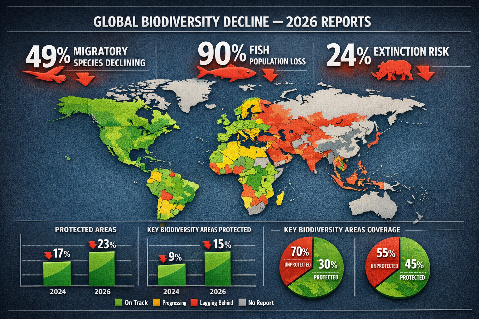
- 49% of migratory species populations are declining, worsening from 44% in 2024, with extinction risk affecting 24% of migratory species[2]
- AI and TinyML technologies are emerging as essential tools for real-time biodiversity detection in remote field locations[4]
- Protected area coverage gaps persist, with over half of 9,372 Key Biodiversity Areas lacking protection status[2]
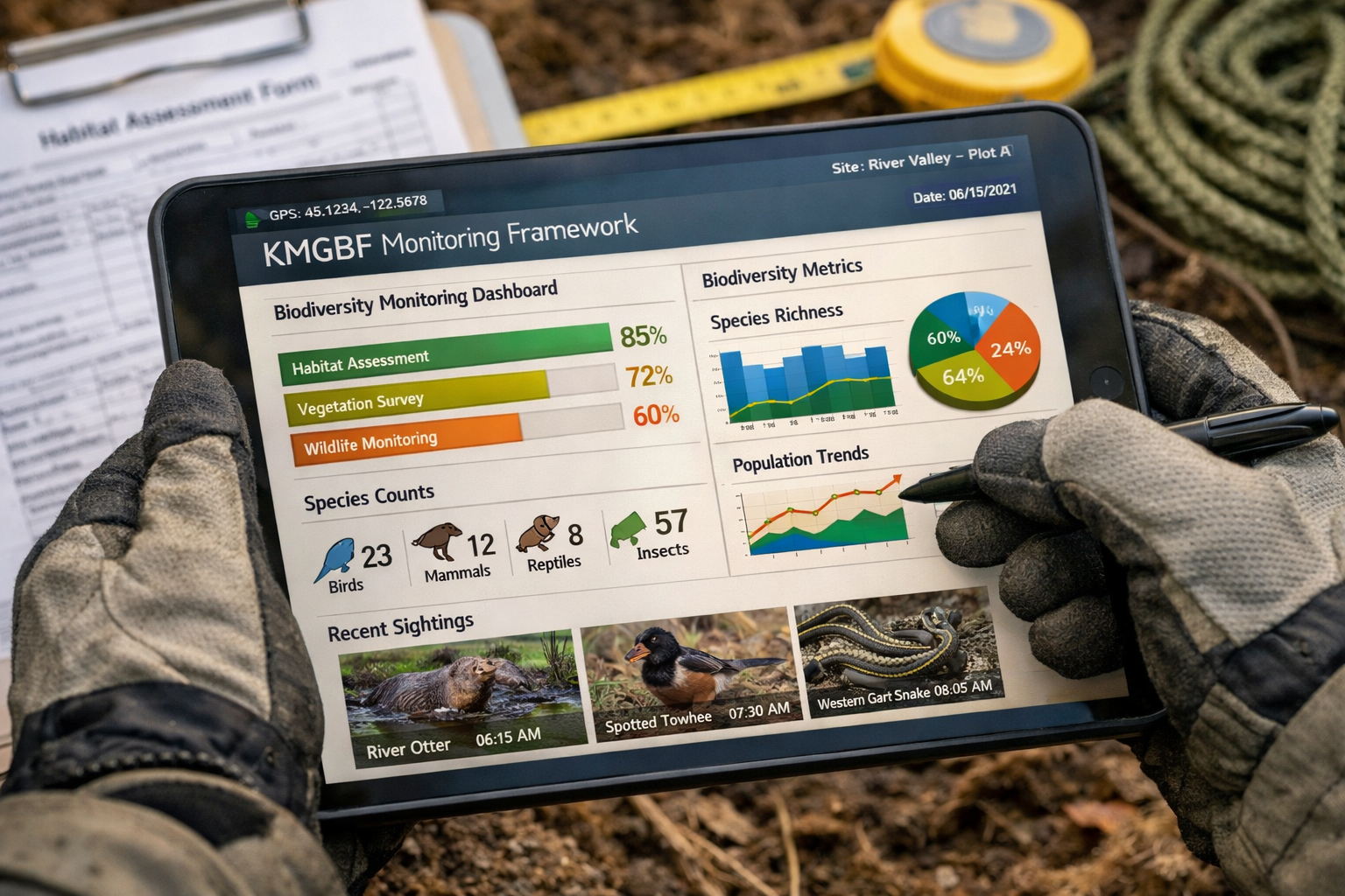
Understanding the KMGBF Monitoring Framework for Field Surveys
The Kunming-Montreal Global Biodiversity Framework established 23 targets spanning ecosystem protection, species conservation, and sustainable resource management. For ecologists conducting field surveys in 2026, the most critical shift involves standardized quantitative reporting that enables cross-border comparison and collective progress assessment.
The PMRR Mechanism: What Changed
The Planning, Monitoring, Reporting and Review (PMRR) mechanism represents the operational backbone of KMGBF implementation. Unlike previous voluntary reporting systems, PMRR establishes:
- Mandatory quantitative indicators for each of the 23 global targets
- Standardized data collection protocols ensuring comparability across nations
- Transparent reporting timelines with fixed submission deadlines
- Accountability mechanisms linking national commitments to verifiable field data[3]
For field ecologists, this means survey methodologies must now capture specific metrics that feed directly into national reporting obligations. Traditional qualitative assessments or region-specific protocols no longer suffice for projects contributing to KMGBF targets.
Key Biodiversity Areas and Survey Prioritization
The 2026 reporting cycle revealed that more than half of the 9,372 identified Key Biodiversity Areas (KBAs) important for protected species lack formal conservation status[2]. This gap creates immediate survey priorities for ecologists working on biodiversity impact assessments.
Priority survey locations now include:
| KBA Category | Survey Focus | Reporting Requirement |
|---|---|---|
| Unprotected KBAs with CMS-listed species | Baseline population assessments | Quarterly monitoring data |
| Marine corridors for migratory fish | Spawning habitat condition | Annual population trends |
| Terrestrial flyways for migratory birds | Stopover site quality | Seasonal occupancy rates |
| Freshwater connectivity zones | Barrier impact assessments | Bi-annual passage success metrics |
Understanding how these priorities align with biodiversity net gain strategies becomes essential for development projects seeking compliance.
Post-COP15 Biodiversity Survey Updates: Protocol Changes by Ecosystem Type
The Post-COP15 Biodiversity Survey Updates: Essential Protocol Changes for Ecologists in 2026 vary significantly by ecosystem, reflecting the differential threats identified in national reports and the 2026 Global Horizon Scan[4].
Terrestrial Ecosystem Protocols 🌳
Soil Moisture Monitoring Integration
The 2026 Global Horizon Scan identified soil moisture decline as an emerging conservation priority affecting terrestrial biodiversity[4]. Standard vegetation surveys must now incorporate:
- Volumetric water content measurements at standardized depths (0-10cm, 10-30cm)
- Seasonal soil moisture profiles correlated with species presence data
- Drought stress indicators for vegetation condition assessments
- Microhabitat moisture mapping for invertebrate and amphibian surveys
This protocol change addresses the recognition that declining soil moisture affects species distributions in ways not captured by traditional climate variables alone.
Macroalgal Habitat Assessment
Loss of kelp forests and other macroalgal habitats emerged as a critical concern in 2026 reporting[4]. Coastal terrestrial-marine interface surveys now require:
- Kelp canopy density measurements using standardized quadrat methods
- Substrate condition assessments for holdfast attachment viability
- Associated species inventories documenting kelp forest biodiversity
- Historical baseline comparisons using photo documentation and local knowledge
Marine Ecosystem Protocols 🌊
Ocean Darkening Documentation
The identification of declining light penetration across ocean regions introduces new survey requirements for marine ecologists[4]:
- Secchi disk depth measurements at standardized intervals
- Photosynthetically active radiation (PAR) profiles using underwater sensors
- Turbidity assessments correlated with productivity indicators
- Phytoplankton community composition analysis at multiple depths
Migratory Fish Population Assessments
With migratory fish populations declining 90% since the 1970s and 97% of CMS-listed migratory fish facing extinction[2], survey protocols now emphasize:
✅ Spawning site condition assessments with habitat quality metrics
✅ Migration barrier inventories documenting dams, weirs, and culverts
✅ Population genetic sampling for connectivity analysis
✅ Environmental DNA (eDNA) protocols for presence/absence confirmation
✅ Acoustic telemetry data integration for movement pattern analysis
These protocols support biodiversity net gain planning for projects affecting aquatic connectivity.
Migratory Species Monitoring 🦅
The deterioration of migratory species status—with populations declining from 44% to 49% between 2024 and 2026[2]—demands enhanced survey protocols:
Stopover Site Quality Assessments
Migratory routes depend on high-quality stopover habitats. New protocols require:
- Refueling rate calculations measuring mass gain during stopover periods
- Habitat availability mapping during peak migration windows
- Disturbance frequency documentation quantifying human impacts
- Food resource abundance surveys timed to migration phenology
Connectivity Corridor Mapping
Survey work must now explicitly document:
- Landscape permeability for terrestrial migratory species
- Flyway condition assessments for aerial migrants
- Marine corridor integrity for aquatic migratory species
- Barrier identification with impact severity classifications
"Over three decades, 70 CMS-listed species became more endangered compared to only 14 that improved in status, highlighting the urgency of enhanced monitoring protocols."[2]
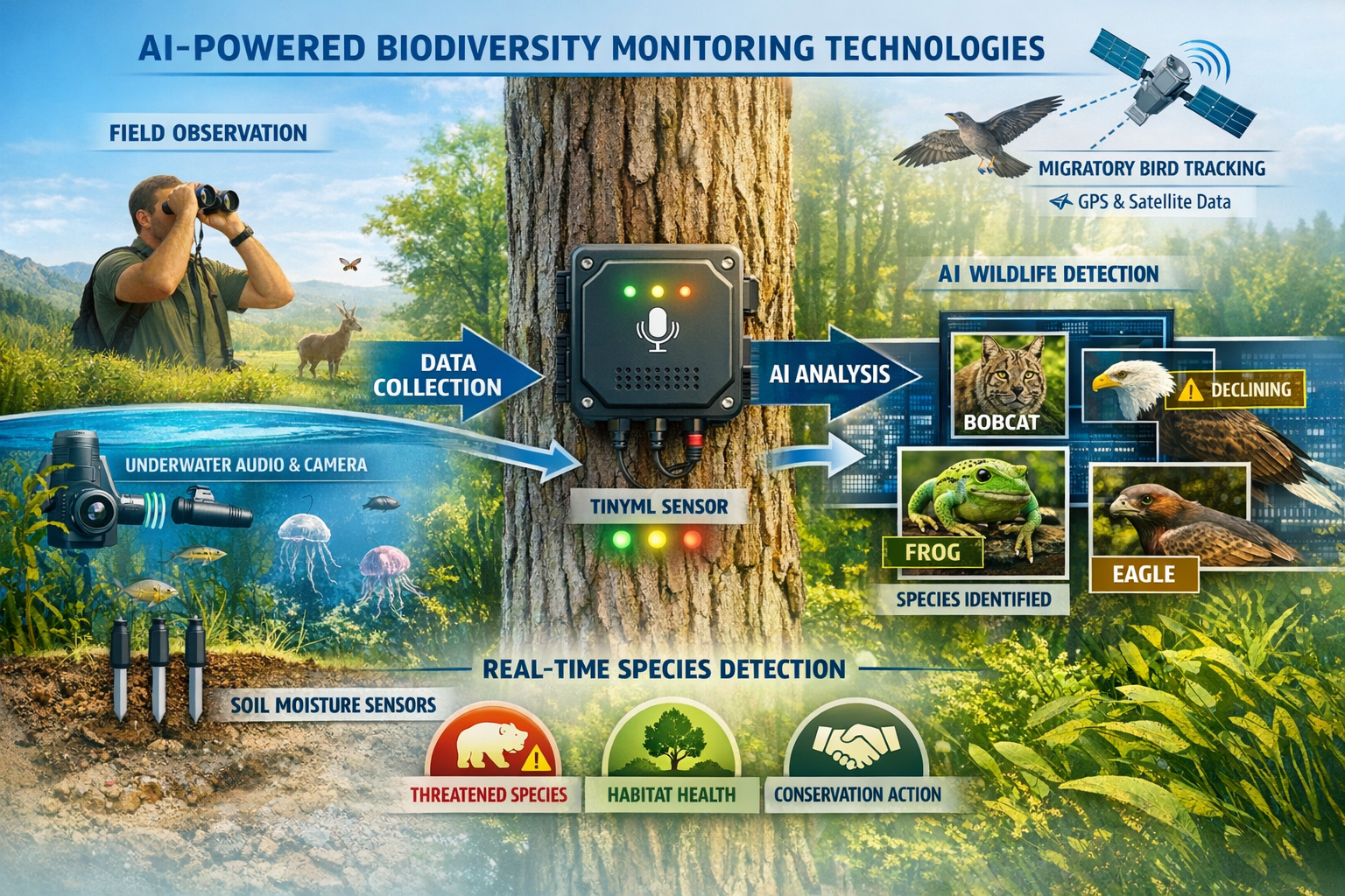
Technological Integration: AI and TinyML in Field Surveys
The 2026 Global Horizon Scan identified Tiny Machine Learning (TinyML) devices and optical AI chips as transformative tools for biodiversity monitoring[4]. These technologies address a critical challenge: conducting standardized surveys in remote locations without reliable internet connectivity or high energy demand.
TinyML Applications for Ecologists
TinyML devices enable real-time species identification and data processing in the field:
Acoustic Monitoring
- Automated species identification from audio recordings
- Continuous monitoring with minimal battery consumption
- Edge processing eliminating need for cloud connectivity
- Standardized call detection ensuring protocol consistency
Camera Trap Enhancement
- On-device image classification reducing data storage requirements
- Real-time species alerts for rare or target species
- Behavior analysis without manual video review
- Privacy-preserving processing for sensitive locations
Optical AI Chips for Visual Surveys
These specialized processors enable:
- Instant species identification from field photographs
- Vegetation structure analysis from drone imagery
- Habitat quality scoring using standardized visual metrics
- Change detection comparing current conditions to baseline imagery
For developers working on projects requiring biodiversity net gain assessments, these technologies offer pathways to more comprehensive baseline data collection and ongoing monitoring.
Implementation Considerations
⚠️ Training Requirements: AI tools require initial training on local species assemblages
⚠️ Validation Protocols: Automated identifications need expert verification samples
⚠️ Data Standardization: Output formats must align with KMGBF reporting requirements
⚠️ Cost-Benefit Analysis: Initial investment vs. long-term monitoring efficiency
Data Management and Reporting Requirements for 2026
The shift to quantitative KMGBF reporting fundamentally changes how ecologists manage and submit survey data. National reporting obligations now flow directly from field-level data collection, creating new requirements for data quality, storage, and accessibility.
Standardized Data Formats
Survey data must now conform to international standards:
Essential Data Fields:
- Taxonomic identifiers using accepted nomenclature (GBIF, WoRMS, etc.)
- Geospatial precision with coordinate uncertainty quantification
- Temporal resolution including survey date, time, and duration
- Observer qualifications documenting surveyor expertise level
- Detection probability estimates for abundance calculations
- Survey effort metrics standardizing across different methodologies
Quality Assurance Protocols
The transparency requirements of PMRR mechanisms demand rigorous quality control:
- Field validation – Photographic or acoustic evidence for rare species
- Expert review – Taxonomic verification by qualified specialists
- Statistical validation – Outlier detection and error checking
- Metadata completeness – Full documentation of survey conditions
- Version control – Tracking data updates and corrections
Integration with National Reporting Systems
Many countries have established centralized biodiversity data platforms to aggregate survey results for KMGBF reporting. Ecologists must understand:
- National data submission portals and their specific requirements
- Data sharing agreements for publicly funded surveys
- Intellectual property considerations for commercial survey work
- Timeline alignment ensuring data availability for reporting cycles
Projects involving biodiversity unit calculations must ensure survey data meets both national reporting standards and local planning requirements.
Regional Variations: UK-Specific Protocol Updates
While KMGBF establishes global frameworks, implementation varies by jurisdiction. In the United Kingdom, post-COP15 protocol changes intersect with domestic biodiversity net gain legislation, creating specific requirements for ecologists.
Biodiversity Net Gain Integration
The UK's mandatory 10% biodiversity net gain requirement for development projects now operates within the KMGBF monitoring framework:
Survey Protocol Alignment:
- Habitat condition assessments using UK Habitat Classification alongside KMGBF indicators
- Metric 4.0 calculations incorporating KMGBF-relevant species data
- Temporal monitoring extending beyond project completion to national reporting cycles
- Off-site provision documentation contributing to protected area expansion targets
Key Biodiversity Area Surveys in the UK
The UK contains numerous KBAs requiring enhanced survey protocols under post-COP15 standards:
Priority Survey Types:
- Seabird colony monitoring at coastal KBAs
- Peatland condition assessments for carbon and biodiversity targets
- Ancient woodland surveys documenting irreplaceable habitat status
- River connectivity assessments for migratory fish populations
Ecologists working on biodiversity credits for developers must ensure surveys capture data relevant to both local planning requirements and national KMGBF commitments.
Statutory Biodiversity Credits and KMGBF Targets
The UK's statutory biodiversity credit system now explicitly links to KMGBF Target 3 (protecting 30% of land and sea by 2030):
- Credit generation sites must contribute to protected area network expansion
- Monitoring protocols must meet both domestic and KMGBF standards
- Reporting timelines align with national KMGBF submission deadlines
- Long-term management extends to 30-year KMGBF implementation period
Understanding these connections helps developers navigate the cost of biodiversity units within the broader conservation finance landscape.
Training and Capacity Building for New Protocols
The rapid evolution of survey protocols creates immediate training needs for practicing ecologists. Professional development in 2026 must address both technical skills and conceptual understanding of KMGBF frameworks.
Essential Training Areas
Technical Skills:
- TinyML device deployment and data interpretation
- Standardized habitat condition assessment using KMGBF indicators
- Quantitative population estimation methods
- Geospatial data management and quality control
- Statistical analysis for trend detection and reporting
Conceptual Knowledge:
- KMGBF target interpretation and survey design implications
- National reporting requirements and data flow pathways
- International biodiversity policy context and evolution
- Conservation finance mechanisms linking surveys to funding
Certification and Competency Standards
Several professional bodies now offer post-COP15 protocol certifications:
✅ KMGBF Monitoring Specialist – International standardized survey methods
✅ AI-Enhanced Biodiversity Surveyor – TinyML and optical AI applications
✅ Migratory Species Assessor – CMS-aligned survey protocols
✅ Marine Biodiversity Technician – Ocean darkening and connectivity surveys
These credentials increasingly appear in tender requirements for publicly funded survey work and biodiversity net gain projects.
Challenges and Solutions in Protocol Implementation
Despite the clear need for standardized protocols, ecologists face practical challenges in implementation during 2026.
Resource Constraints
Challenge: Enhanced protocols require more time, equipment, and expertise than traditional surveys.
Solutions:
- Phased implementation prioritizing highest-risk species and habitats
- Technology investment in AI tools reducing long-term labor costs
- Collaborative surveys pooling resources across organizations
- Citizen science integration for broad-scale data collection
Legacy Data Integration
Challenge: Comparing new standardized data with historical surveys using different methods.
Solutions:
- Conversion factors developed by national authorities
- Parallel surveys using both legacy and new protocols during transition
- Statistical adjustments accounting for methodological differences
- Metadata documentation clearly identifying survey protocol versions
Taxonomic Expertise Gaps
Challenge: Standardized protocols require species-level identification, but taxonomic specialists are increasingly scarce.
Solutions:
- AI identification tools supplementing human expertise
- Morphospecies protocols for groups lacking specialists
- eDNA metabarcoding enabling molecular identification
- International expert networks providing remote verification
Looking Ahead: COP17 and Beyond
The first collective progress review at COP17 (October 19-30, 2026) in Yerevan, Armenia, will establish the baseline for evaluating KMGBF implementation[3]. Survey data collected under new protocols in 2026 will directly inform this assessment, making current field work historically significant.
Expected Outcomes from COP17
Data-Driven Policy Adjustments:
- Target refinement based on implementation feasibility
- Indicator modifications addressing data collection challenges
- Reporting timeline adjustments accommodating national capacity
- Technology adoption recommendations for standardized monitoring
Future Protocol Evolution
The biodiversity monitoring landscape will continue evolving:
2027-2030 Anticipated Changes:
- Satellite remote sensing integration for habitat extent monitoring
- Genomic surveillance protocols for population health assessment
- Climate adaptation indicators linking biodiversity to climate targets
- Ecosystem service quantification connecting biodiversity to human wellbeing
Ecologists should view 2026 protocols as foundational rather than final, maintaining flexibility for continued refinement based on COP17 outcomes and emerging scientific understanding.
Funding Implications
The 2026 national reports revealed significant funding gaps for biodiversity action[6]. This reality affects survey work through:
- Increased competition for limited conservation funding
- Emphasis on cost-effectiveness in survey design
- Private sector engagement through biodiversity credit markets
- Innovative financing mechanisms linking surveys to biodiversity unit transactions
Conclusion
The Post-COP15 Biodiversity Survey Updates: Essential Protocol Changes for Ecologists in 2026 represent a fundamental transformation in how field work contributes to global conservation goals. With 125 countries submitting standardized national reports and COP17 approaching in October, ecologists must rapidly adapt to quantitative, transparent monitoring frameworks that enable collective progress assessment[3].
The urgency is clear: 49% of migratory species populations are declining, 24% face extinction, and migratory fish populations have collapsed by 90%[2]. These alarming trends demand the rigorous, standardized data that new protocols provide.
Actionable Next Steps for Ecologists
- Review national reporting requirements for your jurisdiction and identify relevant KMGBF targets
- Assess current survey protocols against PMRR mechanism standards and identify gaps
- Invest in training for TinyML devices, AI identification tools, and standardized assessment methods
- Establish data management systems meeting international format and quality requirements
- Engage with national biodiversity platforms to understand data submission pathways
- Plan technology adoption balancing initial costs against long-term monitoring efficiency
- Network with specialists building collaborative capacity for taxonomic verification
The transition to post-COP15 protocols presents challenges, but also opportunities. Standardized data enables better conservation decisions, emerging technologies increase survey efficiency, and the global focus on biodiversity creates unprecedented policy and funding attention.
For ecologists working on development projects, understanding these protocol changes is essential for delivering compliant biodiversity assessments that meet both local planning requirements and international conservation commitments.
The field work conducted in 2026 will establish the baseline against which decades of conservation progress will be measured. By embracing standardized protocols, integrating emerging technologies, and maintaining rigorous data quality, ecologists can ensure their surveys contribute meaningfully to reversing biodiversity decline and achieving the ambitious targets of the Kunming-Montreal Global Biodiversity Framework.
References
[1] Cop15 Anniversary Statement – https://www.campaignfornature.org/cop15-anniversary-statement
[2] eurekalert – https://www.eurekalert.org/news-releases/1118733
[3] 2026 Nationalreports – https://www.cbd.int/article/2026-NationalReports
[4] Whats Next For Biodiversity Conservation Insights From The 2026 Horizon Scan – https://www.unep-wcmc.org/en/news/whats-next-for-biodiversity-conservation-insights-from-the-2026-horizon-scan
[5] Global Conference Protecting Migratory Species Kicks Brazil 2026 03 23 En – https://environment.ec.europa.eu/news/global-conference-protecting-migratory-species-kicks-brazil-2026-03-23_en
[6] Big Biodiversity Goals Run Up Against Small Funding Realities – https://news.mongabay.com/2026/02/big-biodiversity-goals-run-up-against-small-funding-realities/
[7] Migratory Species Connect Our World Now We Must Act To Protect Them – https://www.birdlife.org/news/2026/03/23/migratory-species-connect-our-world-now-we-must-act-to-protect-them/
