
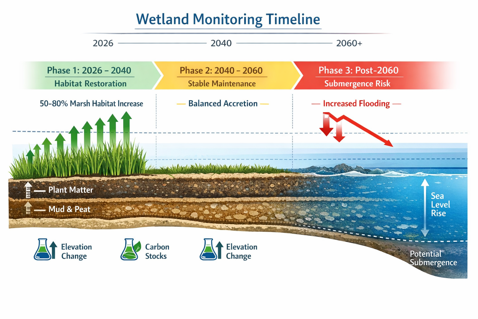
Rising sea levels will outpace marsh accretion rates beyond 2060, causing even successfully restored wetlands to eventually submerge by century's end[1]. This sobering projection transforms how surveyors must approach Wetland Ecology Surveys for BNG: Measuring Restoration Success Amid Sea-Level Rise—shifting from static baseline assessments to dynamic, adaptive monitoring protocols that account for coastal vulnerability while delivering measurable biodiversity gains today.
Wetlands represent some of the most valuable habitats for Biodiversity Net Gain (BNG) projects, providing critical ecosystem services including flood mitigation, carbon sequestration, and species refugia. Yet their position at the land-sea interface makes them uniquely vulnerable to climate change. For surveyors, developers, and landowners pursuing BNG compliance in 2026, understanding how to establish robust baselines and monitor restoration trajectories amid rising seas has become essential.
Key Takeaways
- Restoration delivers measurable gains through mid-century: Studies show 50-80% increases in marsh habitat compared to no-action scenarios, but post-2060 submergence risks require adaptive management strategies[1]
- Baseline surveys must integrate elevation and accretion data: Traditional vegetation assessments alone cannot predict wetland resilience; sediment dynamics and vertical accretion rates are critical metrics
- 63% of Pacific Coast estuaries lack migration space: Spatial constraints threaten long-term restoration success, requiring surveyors to assess landward accommodation zones[2]
- Multi-platform monitoring combines satellite and ground data: Effective tracking of restoration success requires integrated approaches using remote sensing, field surveys, and predictive modeling
- BNG accounting must address temporal uncertainty: 30-year habitat management plans need contingency protocols for accelerated sea-level rise scenarios
Understanding Wetland Vulnerability in BNG Context
The Dual Challenge: Restoration Gains vs. Sea-Level Rise
Wetland restoration projects demonstrate remarkable success in the near and medium term. Research using the Sea Level Affecting Marshes Model (SLAMM) found that implemented restoration would increase total marsh habitat by approximately 50-80% through mid-century compared to scenarios without intervention[1]. This substantial gain makes wetlands attractive candidates for off-site BNG delivery, particularly for developers seeking high-value habitat units.
However, the same research reveals a critical inflection point: beyond 2060, rising sea levels are projected to outpace marsh accretion rates, resulting in eventual submergence even under restored conditions by the end of the 21st century[1]. This temporal vulnerability creates unique challenges for BNG compliance frameworks that require 30-year habitat management commitments.
Spatial Constraints and Migration Pathways
A comprehensive spatial analysis of 61 Pacific Coast estuaries identified that 63% of estuaries lack sufficient landward migration space to accommodate tidal wetland migration in response to sea-level rise[2]. This constraint directly impacts restoration potential and long-term habitat viability for protected species.
The same study found that nature-based restoration solutions could increase tidal wetland area by 61% across the Pacific Coast, with California containing 83% of available restoration area (10% Washington, 7% Oregon)[2]. Four estuarine drainage areas demonstrate potential to more than double their tidal wetland area through restoration, with Nooksack EDA in Washington showing the largest potential at 3.5 times its current extent[2].
For surveyors conducting biodiversity impact assessments, these spatial realities require evaluation of not just current habitat quality but future accommodation space and migration corridors.
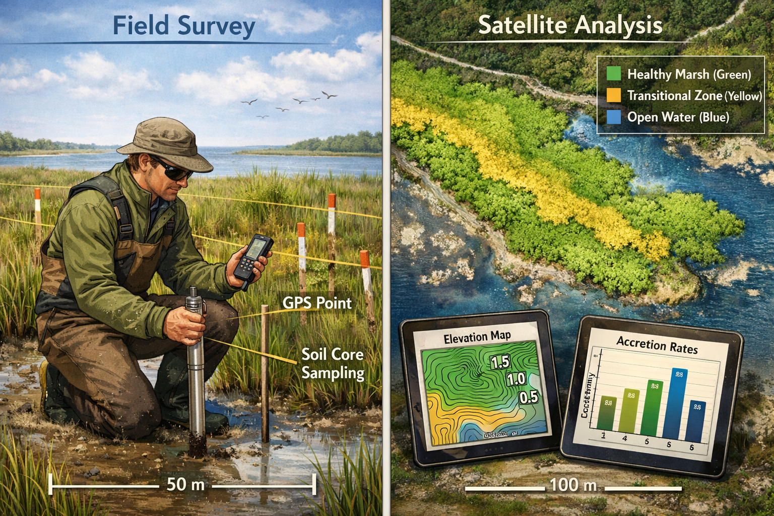
Establishing Robust Baselines: Survey Protocols for Wetland BNG
Essential Baseline Metrics
Wetland Ecology Surveys for BNG: Measuring Restoration Success Amid Sea-Level Rise require comprehensive baseline data that extends beyond traditional habitat surveys. Key metrics include:
Elevation and Topography 📏
- High-resolution digital elevation models (DEMs) with vertical accuracy ±5cm
- Tidal datum relationships (mean high water, mean sea level)
- Microtopographic variation that influences vegetation zonation
- Elevation relative to projected sea-level rise scenarios
Vegetation Community Structure 🌿
- Species composition and percent cover by tidal zone
- Native vs. invasive species ratios
- Vegetation health indices (NDVI from satellite data)
- Presence of indicator species for marsh maturity
Sediment Dynamics ⚖️
- Vertical accretion rates using marker horizons or feldspar clay
- Sediment organic carbon stocks
- Bulk density and soil composition
- Erosion patterns and channel morphology
Hydrological Connectivity 💧
- Tidal range and inundation frequency
- Freshwater inputs and salinity gradients
- Drainage patterns and channel networks
- Barriers to tidal exchange (levees, culverts, tide gates)
Integrating Satellite and Ground Data
Modern wetland surveys leverage multiple data sources to create comprehensive baselines:
| Data Source | Metrics Provided | Temporal Resolution | Spatial Coverage |
|---|---|---|---|
| Satellite imagery | Vegetation indices, extent mapping, change detection | 5-16 days | Complete site coverage |
| LiDAR | Elevation, topography, vegetation structure | Single acquisition | High-resolution DEM |
| Ground surveys | Species ID, soil cores, water quality | Seasonal/annual | Sample points/transects |
| Drone/UAV | High-res imagery, structure from motion | On-demand | Site-specific detail |
| Tide gauges | Water level, inundation patterns | Continuous | Point measurements |
Recent USGS modeling efforts focus specifically on sediment accretion rates, elevation change, and soil organic carbon stocks to assess future wetland vulnerability[3]. These parameters directly inform restoration success metrics and should be incorporated into baseline protocols.
UK Landscape Recovery Applications
UK wetland restoration projects demonstrate practical application of these principles. Landscape Recovery round 1 projects expect to restore over 600 kilometres of rivers with recovery of more than 250 species, including fish, amphibians, waterfowl, and beaver reintroduction[4]. These initiatives focus on reducing nutrient pollution and improving flood resilience—co-benefits that enhance BNG value.
At least 3 kilometres of streams and the River Glen will be restored to more natural courses with meanders and seasonal pools supporting wetland species after centuries of drainage and canalisation[4]. For surveyors, these projects illustrate how baseline assessments must document not just current degraded conditions but also reference historical conditions and restoration potential.
Understanding how to achieve 10% Biodiversity Net Gain in wetland contexts requires recognizing both the high multiplier values these habitats provide and the complexity of measuring success over time.
Monitoring Restoration Success: Adaptive Protocols for Long-Term Tracking
Temporal Monitoring Framework
Effective Wetland Ecology Surveys for BNG: Measuring Restoration Success Amid Sea-Level Rise require structured temporal monitoring that captures both rapid establishment phases and longer-term trajectory:
Year 0-3: Establishment Phase 🌱
- Quarterly vegetation surveys during growing season
- Annual elevation surveys at permanent benchmarks
- Monthly hydrological monitoring (water levels, salinity)
- Quarterly invasive species assessments
- Baseline wildlife surveys (breeding birds, amphibians)
Year 4-10: Development Phase 📈
- Biannual vegetation community assessments
- Annual accretion measurements
- Annual elevation surveys
- Biannual water quality monitoring
- Annual wildlife population surveys
Year 11-30: Maintenance Phase ✅
- Annual vegetation monitoring
- Triennial accretion rate verification
- Annual elevation change detection via satellite
- Biannual targeted species surveys
- Quinquennial comprehensive reassessment
This phased approach balances intensive early monitoring—when intervention opportunities are greatest—with cost-effective long-term tracking that satisfies BNG reporting requirements.
Key Performance Indicators for Restoration Success
Measuring success requires clearly defined, quantifiable indicators:
Ecological Indicators 🦆
- Native plant species richness (target: >15 species per 100m²)
- Vegetation cover in target zones (target: >80% in appropriate tidal elevations)
- Presence of indicator species (e.g., saltmarsh sparrow, rail species)
- Invertebrate community composition
- Fish utilization (nursery function)
Physical Process Indicators 🌊
- Vertical accretion rate (target: ≥ local sea-level rise rate)
- Marsh surface elevation change
- Channel network development
- Sediment organic carbon accumulation
- Tidal prism restoration
Resilience Indicators 💪
- Elevation capital (height above mean high water)
- Sediment supply adequacy
- Landward migration potential
- Edge erosion rates
- Storm recovery capacity
NOAA research emphasizes the need for ongoing monitoring and adaptation to ensure restoration projects achieve intended objectives, particularly as long-term performance has been identified as a significant hurdle to adopting nature-based solutions[1].
Adaptive Management Triggers
Monitoring data should inform adaptive management decisions. Establish clear trigger points that prompt intervention:
| Indicator | Warning Threshold | Critical Threshold | Management Response |
|---|---|---|---|
| Accretion rate | <50% of SLR rate | <25% of SLR rate | Sediment augmentation, thin-layer deposition |
| Native cover | <60% target zones | <40% target zones | Invasive control, replanting |
| Elevation loss | >5cm over 3 years | >10cm over 5 years | Hydrological modifications, sediment addition |
| Invasive species | >20% cover | >40% cover | Targeted removal, competitive planting |
| Channel erosion | >10% edge retreat | >25% edge retreat | Bank stabilization, flow management |
These thresholds should be site-specific and adjusted based on local conditions and restoration objectives. For projects pursuing biodiversity unit sales, demonstrating proactive adaptive management enhances credibility and long-term value.
Integrating Climate Projections into BNG Planning
Scenario-Based Assessment
Given the post-2060 submergence projections, responsible wetland BNG planning must incorporate climate scenarios into baseline assessments and monitoring protocols:
Conservative Scenario (RCP 4.5) 🌡️
- 0.5m sea-level rise by 2100
- Moderate accretion rates may maintain some marsh areas
- Focus on optimizing sediment supply and vegetation health
Moderate Scenario (RCP 6.0) ⚠️
- 0.75m sea-level rise by 2100
- Accretion likely insufficient without intervention
- Sediment augmentation and migration space critical
High-Impact Scenario (RCP 8.5) 🔥
- 1.0m+ sea-level rise by 2100
- Submergence likely even with intervention
- Emphasis on maximizing near-term gains and facilitating migration
Surveyors should model habitat trajectories under multiple scenarios and clearly communicate temporal limitations to developers and landowners considering BNG projects.
Contingency Planning for BNG Compliance
The 30-year habitat management requirement for BNG creates potential compliance risks if wetlands deteriorate faster than projected. Mitigation strategies include:
Spatial Redundancy 📍
- Restore larger areas than minimum required for target units
- Create multiple restoration sites across elevation gradients
- Establish buffer zones and migration corridors
Temporal Staging ⏰
- Phase restoration to maintain habitat availability throughout commitment period
- Plan for sequential site transitions as older areas decline
- Build in replacement capacity for late-period losses
Financial Reserves 💰
- Escrow funds for adaptive interventions (sediment addition, replanting)
- Insurance mechanisms for catastrophic loss events
- Contingency budgets for accelerated management needs
Alternative Compliance Pathways 🔄
- Pre-negotiated substitution protocols if primary sites fail
- Portfolio approaches spreading risk across multiple habitat types
- Agreements for purchasing statutory biodiversity credits if natural processes exceed intervention capacity
These safeguards protect both ecological outcomes and developer compliance obligations in an uncertain climate future.
Technology and Tools for Enhanced Monitoring Efficiency
Remote Sensing Applications
Satellite and aerial platforms dramatically improve monitoring efficiency and data quality:
Multispectral Satellite Imagery 🛰️
- Sentinel-2 (10m resolution, 5-day revisit): Vegetation health, extent mapping
- Landsat 8/9 (30m resolution, 16-day revisit): Long-term change detection
- Planet Labs (3m resolution, daily): High-frequency monitoring
- Applications: NDVI tracking, water extent mapping, vegetation classification
Synthetic Aperture Radar (SAR) 📡
- Sentinel-1 (10m resolution, 6-day revisit): All-weather monitoring
- Applications: Inundation mapping, soil moisture, structural changes
- Advantage: Cloud penetration for consistent UK monitoring
LiDAR and Photogrammetry ✈️
- Airborne LiDAR: High-precision elevation models
- UAV Structure-from-Motion: Cost-effective site-scale topography
- Applications: Elevation change detection, vegetation structure, channel morphology
Field Data Collection Innovations
Modern ground survey tools enhance data quality and efficiency:
Real-Time Kinematic (RTK) GPS 📍
- Centimeter-level accuracy for elevation monitoring
- Efficient permanent benchmark establishment
- Rapid transect surveys with high spatial precision
Automated Sensors 🤖
- Continuous water level and salinity loggers
- Soil moisture and temperature sensors
- Time-lapse cameras for phenology and wildlife
- Acoustic recorders for avian and amphibian monitoring
Mobile Data Collection 📱
- Tablet-based field forms with GPS integration
- Photo documentation with automatic geotagging
- Offline capability for remote wetland sites
- Direct database integration reducing transcription errors
These technologies enable more frequent, accurate, and cost-effective monitoring—essential for demonstrating BNG compliance over 30-year timeframes. For developers navigating BNG requirements, investing in robust monitoring infrastructure reduces long-term compliance risk.
Case Study Applications: Translating Research to Practice
Pacific Coast Restoration Potential
The spatial analysis of Pacific Coast estuaries provides concrete guidance for surveyors assessing restoration sites[2]. When evaluating potential wetland BNG locations, prioritize:
High-Potential Zones ⭐
- Estuaries with >200% restoration potential (e.g., Nooksack EDA)
- Areas with adequate landward migration space
- Sites with active sediment supply
- Locations with minimal development constraints
Medium-Potential Zones ⚙️
- Estuaries with 50-100% expansion potential
- Sites requiring levee removal or tide gate modifications
- Areas with moderate migration space
- Locations needing sediment augmentation
Constrained Zones ⚠️
- Estuaries with <25% expansion potential
- Heavily developed shorelines limiting migration
- Areas with sediment deficit
- Sites requiring intensive ongoing management
This risk-stratified approach helps developers and landowners make informed decisions about where to invest in wetland BNG projects, balancing ecological potential against climate vulnerability and management requirements.
UK River and Wetland Integration
UK Landscape Recovery projects demonstrate integration of wetland restoration with broader catchment management[4]. Surveyors should assess:
Hydrological Connectivity 💧
- Upstream land use impacts on sediment and nutrient loads
- Opportunities for natural flood management co-benefits
- Integration with river restoration initiatives
- Coordination with agricultural stewardship schemes
Species Recovery Objectives 🦫
- Alignment with protected species recovery plans
- Habitat network connectivity for amphibians and waterfowl
- Opportunities for species reintroductions (beavers, water voles)
- Coordination with existing conservation designations
Multiple Benefit Delivery 🎯
- Carbon sequestration quantification
- Flood attenuation capacity
- Water quality improvement (nutrient removal)
- Recreation and access enhancements
This integrated approach maximizes BNG value while building resilience against climate impacts. Understanding why BNG is important to the UK helps contextualize wetland projects within broader environmental policy objectives.
Practical Recommendations for Surveyors and Developers
Survey Design Essentials
When planning Wetland Ecology Surveys for BNG: Measuring Restoration Success Amid Sea-Level Rise, incorporate these essential elements:
Pre-Survey Planning 📋
- Review historical maps, aerial photos, and previous surveys
- Obtain high-resolution elevation data (LiDAR if available)
- Model tidal inundation patterns and sea-level rise scenarios
- Identify reference sites for comparison
- Coordinate with regulatory agencies on monitoring requirements
Field Survey Protocol 🥾
- Establish permanent photo points and monitoring transects
- Install elevation benchmarks at multiple tidal zones
- Collect soil cores for accretion baseline
- Document hydrological features (channels, pools, barriers)
- Survey vegetation communities using standardized methods
- Record wildlife observations and habitat features
Data Management 💾
- Use standardized habitat classification systems
- Maintain detailed metadata for all measurements
- Archive raw data and processed results separately
- Implement quality control procedures
- Plan for long-term data accessibility (30+ years)
Cost-Benefit Optimization
Balancing monitoring intensity with budget constraints requires strategic prioritization:
High-Value Monitoring 💎
- Annual satellite imagery analysis (low cost, high value)
- Biennial elevation surveys at key benchmarks
- Annual vegetation community assessments
- Targeted wildlife surveys for indicator species
- Event-based monitoring after major storms
Lower-Priority Activities 📊
- Continuous sensor networks (unless specific concerns)
- Intensive invertebrate sampling (unless required)
- Frequent drone surveys (diminishing returns)
- Detailed soil chemistry (unless nutrient issues)
For small development projects with BNG requirements, consider pooled monitoring approaches where multiple projects share costs for satellite analysis and periodic specialist surveys.
Stakeholder Communication
Effective communication of monitoring results builds confidence in wetland BNG projects:
Annual Reporting Should Include 📄
- Clear comparison to baseline conditions
- Progress toward restoration targets
- Photographs from permanent points
- Simple data visualizations (graphs, maps)
- Adaptive management actions taken
- Upcoming monitoring activities
Transparency About Uncertainty 🔍
- Acknowledge climate projection ranges
- Explain temporal limitations of restoration success
- Communicate adaptive management triggers
- Describe contingency plans for adverse scenarios
This transparency is particularly important when buying or selling biodiversity units, as it establishes realistic expectations and demonstrates professional due diligence.
Conclusion
Wetland Ecology Surveys for BNG: Measuring Restoration Success Amid Sea-Level Rise represent both an opportunity and a challenge for achieving biodiversity objectives in 2026 and beyond. The evidence is clear: well-designed wetland restoration can deliver substantial habitat gains through mid-century, with potential increases of 50-80% in marsh extent compared to no-action scenarios[1]. These gains make wetlands valuable contributors to BNG portfolios, offering high-distinctiveness habitat units and multiple ecosystem service co-benefits.
However, the post-2060 submergence risk demands honest assessment and adaptive planning. Surveyors must establish comprehensive baselines that extend beyond traditional vegetation surveys to include elevation dynamics, sediment processes, and spatial constraints. Monitoring protocols must integrate satellite remote sensing with strategic ground surveys, creating cost-effective long-term tracking systems that detect both success and emerging risks.
The spatial analysis revealing that 63% of estuaries lack adequate migration space[2] underscores the importance of site selection and landscape-scale planning. Restoration projects must consider not just current conditions but future accommodation space, sediment supply adequacy, and connectivity to broader habitat networks.
Next Steps for Action
For Surveyors 🔬
- Develop standardized protocols integrating elevation, accretion, and vegetation metrics
- Invest in training on remote sensing analysis and climate modeling
- Build partnerships with academic institutions for specialized monitoring support
- Contact specialists for guidance on complex wetland assessments
For Developers 🏗️
- Engage wetland specialists early in BNG planning
- Budget for robust baseline surveys and long-term monitoring
- Consider portfolio approaches spreading risk across multiple sites
- Review frequently asked questions about BNG to understand compliance requirements
For Landowners 🌾
- Assess restoration potential considering both near-term gains and long-term sustainability
- Explore integration with agricultural stewardship schemes
- Understand monitoring commitments before entering agreements
- Consult landowner guidance resources for detailed information
The intersection of wetland restoration, biodiversity net gain, and climate adaptation represents one of the defining environmental challenges of this decade. By establishing rigorous survey protocols, implementing adaptive monitoring systems, and planning transparently for climate uncertainty, the conservation community can maximize near-term biodiversity gains while building resilience for an uncertain future. The wetlands we restore today will provide critical habitat and ecosystem services through mid-century—and with careful management, may yet adapt to survive beyond.
References
[1] Nbs Increasing Resilience To Slr – https://coastalscience.noaa.gov/news/nbs-increasing-resilience-to-slr/
[2] Pmc11968946 – https://pmc.ncbi.nlm.nih.gov/articles/PMC11968946/
[3] Brown Bag Science Modeling Sea Level Rise Vulnerability South Bay Tidal Wetlands – https://www.southbayrestoration.org/media/brown-bag-science-modeling-sea-level-rise-vulnerability-south-bay-tidal-wetlands
[4] Landscape Recovery First Projects Move Into Delivery Phase – https://defrafarming.blog.gov.uk/2025/08/29/landscape-recovery-first-projects-move-into-delivery-phase/
