
The ground beneath our feet is drying at an alarming rate. Recent research reveals that global soil moisture has experienced sharp depletion over the past 40 years, with particularly dramatic losses observed between 2003 and 2021 [2]. This widespread soil moisture decline threatens biodiversity hotspots worldwide, creating urgent challenges for ecology professionals tasked with monitoring and protecting vulnerable terrestrial ecosystems. For surveyors working in drought-prone regions, understanding effective Soil Moisture Decline Surveys: Field Techniques for Ecology Surveyors in Drought-Vulnerable Terrestrial Ecosystems has become essential to establishing accurate baselines and implementing resilient monitoring programs.
The consequences of soil moisture loss extend far beyond agricultural concerns. Between 2003 and 2011, Earth's pole shifted 58 centimeters toward 93° East Longitude—a measurable geophysical consequence of continued soil moisture decline and terrestrial water storage reduction [2]. This dramatic shift underscores the planetary-scale implications of the changes ecology surveyors now document in the field.
Key Takeaways
- Global soil moisture depletion has accelerated dramatically since 2003, with regional water storage losses concentrated in Africa, Asia, Europe, and South America, requiring ecology surveyors to establish new baseline measurements in affected terrestrial ecosystems [2]
- Low-cost field techniques like the "feel and appearance method" allow surveyors to estimate soil water content within 10% accuracy, while hand-push probes and soil augers provide reliable depth profiling for drought monitoring programs [1]
- Modern monitoring combines traditional soil sampling with advanced technologies including electrical resistance sensors, infrared satellite imagery, and wireless data loggers that enable real-time tracking of moisture decline patterns [1]
- Systematic survey protocols must account for spatial variability across drought-vulnerable ecosystems, with multiple sampling points at varying depths to capture the full picture of moisture distribution and decline trends
- Integration of remote sensing data with ground-truthing establishes robust monitoring frameworks that support biodiversity conservation efforts and inform adaptive management strategies in water-stressed environments
Understanding the Global Context of Soil Moisture Decline
The scientific evidence for widespread soil moisture depletion has become increasingly compelling. Research published in Science journal demonstrates that the rate of decline observed from 2003 to 2021 represents a sharp acceleration compared to the 1979-1999 period [2]. This abrupt change signals a fundamental shift in terrestrial water dynamics that ecology surveyors must now account for in their field assessments.
Primary Drivers of Terrestrial Water Loss
Precipitation deficits, stable evapotranspiration caused by global warming, and changing rainfall patterns have been identified as key drivers of the abrupt decline in terrestrial water storage [2]. Understanding these mechanisms helps surveyors interpret field data within the broader climate context.
The geographic distribution of water storage losses reveals concerning patterns. Regional impacts are concentrated in Africa, Asia, Europe, and South America, with affected areas in Asia and Europe expanding from northeastern Asia and eastern Europe to broader regions across East and Central Asia and Central Europe following sharp depletion observed between 2000 and 2002 [2].
Implications for Biodiversity Conservation
Drought-vulnerable terrestrial ecosystems face multiple stressors as soil moisture declines:
- 🌱 Vegetation stress leading to reduced plant vigor and altered species composition
- 🦎 Habitat degradation affecting soil-dwelling organisms and wildlife dependent on moisture-rich environments
- 💧 Groundwater recharge disruption impacting wetland connectivity and riparian zones
- 🔥 Increased wildfire risk in grasslands and forest ecosystems with depleted soil moisture reserves
For biodiversity surveyors working to document and protect vulnerable species, soil moisture monitoring provides critical baseline data that informs conservation strategies and habitat management decisions.
Essential Field Techniques for Soil Moisture Decline Surveys in Drought-Vulnerable Terrestrial Ecosystems
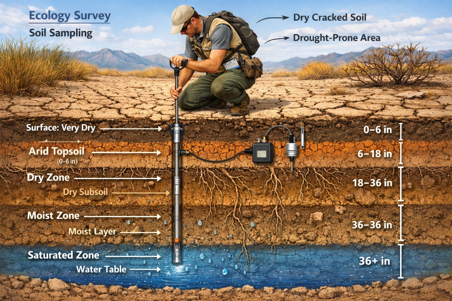
Effective soil moisture surveys require a combination of proven field methods and careful protocol design. The selection of appropriate techniques depends on survey objectives, budget constraints, ecosystem characteristics, and the level of precision required for monitoring programs.
Low-Cost Manual Assessment Methods
The "feel and appearance method" remains one of the most practical low-cost field techniques for ecology surveyors. With proper training and practice, practitioners can reliably estimate soil water content to within 10% of actual moisture levels using walnut-sized soil samples from various depths in the root zone [1].
This tactile assessment method involves:
- Collecting soil samples at predetermined depths (typically 0-15cm, 15-30cm, 30-60cm)
- Squeezing the sample firmly in the palm to assess texture and cohesion
- Observing soil behavior when released (does it hold shape, crumble, or fall apart?)
- Comparing observations against reference charts specific to soil texture types
Hand-push probes with soil augers allow surveyors to determine wetted soil depth by pushing the probe to the point where it stops at dry soil (or rocks), and can retrieve samples by twisting and pulling the probe from the soil [1]. These tools provide essential depth profile information without requiring expensive equipment.
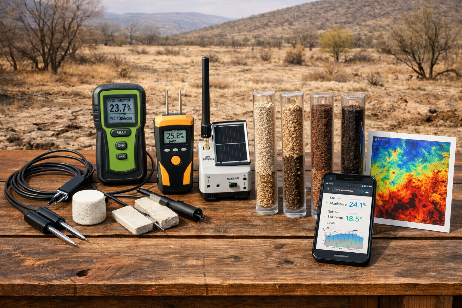
Intermediate Technology: Resistance-Based Sensors
Electrical resistance sensors detect soil moisture by measuring conductivity changes, as wet soil conducts electricity better than dry soil. Porous sensor blocks absorb water and achieve equilibrium with surrounding soil for accurate moisture tension readings [1].
Key advantages of resistance sensors include:
- ✅ Relatively affordable compared to advanced technologies
- ✅ Can be left in place for continuous monitoring
- ✅ Provide quantitative data suitable for statistical analysis
- ✅ Work well across different soil texture types with proper calibration
When deploying resistance sensors in drought-vulnerable terrestrial ecosystems, surveyors should install multiple units at varying depths and locations to capture spatial variability across the survey area.
Advanced Remote Sensing Applications
Infrared satellite imagery is emerging as an important method for tracking evapotranspiration, soil moisture, and carbon flux levels at field and farm scales, using NASA satellite data on leaf temperature, solar radiation, and crop leaf size [1]. Companies like IrriWatch are already providing these services for agricultural applications, but the technology holds tremendous promise for ecological monitoring.
Remote sensing offers several advantages for large-scale soil moisture decline surveys:
| Method | Spatial Coverage | Temporal Resolution | Best Application |
|---|---|---|---|
| Infrared satellite | Large areas (km²) | Daily to weekly | Regional drought patterns |
| Microwave remote sensing | Medium to large areas | Daily | Soil moisture mapping |
| Ground-penetrating radar | Small to medium plots | On-demand | Subsurface moisture profiles |
| Cosmic ray sensors | Medium areas (hectares) | Continuous | Landscape-scale monitoring |
The integration of satellite data with ground-truthing measurements creates robust monitoring frameworks that support biodiversity conservation efforts across extensive drought-vulnerable landscapes.
Emerging Technologies for Noninvasive Monitoring
Emerging "noninvasive" soil moisture methods under development or commercially available include actively heated fiber optics, microwaves, ground-penetrating radar, radio frequency identification, hydrogels, seismoelectric approaches, cosmic ray sensors, and electromagnetic induction [1]. These technologies minimize soil disturbance while providing detailed moisture data.
Cosmic ray neutron sensors represent a particularly promising development for ecology surveyors. These devices measure neutrons produced by cosmic rays interacting with soil hydrogen atoms (primarily in water molecules), providing average soil moisture readings across areas of approximately 300 meters radius and depths up to 50 centimeters.
Implementing Systematic Survey Protocols for Drought-Vulnerable Ecosystems
Successful soil moisture decline surveys require careful planning and systematic implementation. The following framework provides guidance for ecology surveyors developing monitoring programs in drought-vulnerable terrestrial ecosystems.
Survey Design Considerations
Spatial sampling strategy forms the foundation of effective moisture monitoring. Surveyors must balance the need for comprehensive coverage against practical constraints of time and resources.
Recommended approaches include:
- Stratified random sampling based on vegetation types, topographic position, and soil classifications
- Transect-based designs that capture moisture gradients from upland to lowland positions
- Grid-based systematic sampling for uniform coverage across homogeneous areas
- Targeted sampling at biodiversity hotspots or areas of particular conservation concern
The number of sampling points depends on ecosystem heterogeneity and survey objectives, but typically ranges from 15-30 locations for small sites (1-10 hectares) to 50+ points for larger landscapes.
Temporal Monitoring Schedules
Establishing baseline measurements requires repeated surveys across seasons and years to distinguish natural variability from long-term decline trends. Recommended monitoring frequencies include:
- 🗓️ Intensive phase (Year 1): Monthly measurements to capture seasonal patterns
- 🗓️ Establishment phase (Years 2-3): Quarterly measurements during key phenological periods
- 🗓️ Long-term monitoring (Years 4+): Biannual measurements (typically spring and late summer)
- 🗓️ Event-based sampling: Additional measurements following significant rainfall or drought periods
This adaptive schedule allows surveyors to optimize effort while maintaining data quality sufficient for detecting meaningful decline trends.
Data Collection Protocols and Quality Control
Standardized field protocols ensure data consistency across survey teams and time periods. Essential protocol elements include:
- Site characterization: Document GPS coordinates, elevation, slope, aspect, vegetation type, and soil classification at each sampling point
- Depth profiling: Collect measurements at consistent depth intervals (0-15cm, 15-30cm, 30-60cm, 60-90cm where feasible)
- Replicate sampling: Take multiple measurements at each point to assess local variability
- Calibration procedures: Regularly calibrate sensors against gravimetric soil samples
- Weather documentation: Record air temperature, precipitation history, and recent weather conditions
- Photographic documentation: Capture standardized photos showing site conditions and vegetation status
Data loggers with wireless transmission systems now enable real-time monitoring on phones and computers, with some apps allowing automated irrigation control or scheduling recommendations. The USDA Agricultural Research Service's free Irrigator Pro app for peanut, corn, and cotton growers transmits sensor data to cloud servers for customized recommendations [1]. Similar systems can be adapted for ecological monitoring applications.
Integration with Biodiversity Assessment Programs
Soil moisture decline surveys provide maximum value when integrated with broader biodiversity assessment and habitat monitoring programs. This integration allows surveyors to:
- Correlate moisture patterns with vegetation community composition and health
- Identify moisture thresholds associated with habitat degradation
- Predict species distribution changes under continued drought stress
- Prioritize conservation interventions in areas experiencing rapid moisture decline
- Support biodiversity net gain planning by establishing pre-intervention baselines
For development projects in drought-vulnerable areas, soil moisture data contributes essential information for creating effective biodiversity plans that account for water stress as a limiting factor for habitat creation and restoration success.
Advanced Analysis and Interpretation of Soil Moisture Decline Data
Raw field measurements become meaningful only through careful analysis and interpretation within ecological context. Surveyors must employ appropriate statistical methods and consider multiple factors when evaluating moisture decline patterns.
Statistical Approaches for Trend Detection
Detecting significant moisture decline trends requires sufficient temporal data and appropriate statistical methods:
- Mann-Kendall trend test: Non-parametric method ideal for detecting monotonic trends in time series data with seasonal patterns
- Linear regression analysis: Quantifies rate of decline and provides confidence intervals for trend estimates
- Change point analysis: Identifies specific time periods when abrupt shifts in moisture patterns occurred
- Spatial interpolation: Creates continuous moisture maps from point measurements using kriging or inverse distance weighting
When analyzing data from drought-vulnerable terrestrial ecosystems, surveyors should account for:
- Natural inter-annual variability driven by precipitation fluctuations
- Seasonal patterns related to plant phenology and evapotranspiration cycles
- Spatial autocorrelation between nearby sampling points
- Measurement uncertainty and sensor calibration drift over time
Interpreting Results in Climate Context
Soil moisture measurements gain additional meaning when evaluated alongside regional climate data. Surveyors should compare field observations against:
- Standardized Precipitation Index (SPI): Indicates precipitation deficits relative to long-term averages
- Palmer Drought Severity Index (PDSI): Integrates precipitation and temperature to assess drought intensity
- Evapotranspiration estimates: Reveals water demand patterns independent of precipitation
- Regional groundwater monitoring: Provides context for subsurface moisture dynamics
The 17th annual National Soil Moisture Workshop scheduled for June 9-10, 2026, at the University of North Carolina at Asheville offers valuable professional development opportunities for surveyors seeking to enhance their analytical capabilities [5]. The 2026 workshop theme is "Soil Moisture and Natural Hazards," with special emphasis on soil moisture applications for wildfire prediction and management, drought prediction and tracking, flood forecasting, landslide prediction, and public health and safety [5].
Communicating Findings to Stakeholders
Effective communication of soil moisture decline survey results requires tailoring presentations to different audiences:
For conservation managers and ecologists:
- Emphasize ecological implications of observed moisture trends
- Highlight habitat types and species most vulnerable to continued decline
- Recommend adaptive management strategies based on moisture projections
For landowners and developers:
- Connect moisture patterns to sustainable land management practices
- Demonstrate how moisture monitoring supports biodiversity net gain objectives
- Provide actionable recommendations for site-specific interventions
For policy makers and planners:
- Present regional patterns and landscape-scale implications
- Quantify risks to ecosystem services and biodiversity assets
- Support evidence-based decision making for conservation prioritization
Visual communication tools such as time-series graphs, spatial heat maps, and comparative charts help stakeholders quickly grasp key findings and trends.
Building Resilient Long-Term Monitoring Programs
Establishing sustainable soil moisture monitoring programs in drought-vulnerable terrestrial ecosystems requires careful consideration of resources, partnerships, and adaptive management approaches.
Resource Optimization Strategies
Budget constraints often limit the scope and duration of monitoring programs. Surveyors can maximize program sustainability through:
- Tiered monitoring approaches: Combine intensive monitoring at key sentinel sites with less frequent broader surveys
- Technology mixing: Use expensive automated sensors at core sites while employing low-cost manual methods elsewhere
- Volunteer engagement: Train citizen scientists for basic moisture assessments under professional supervision
- Equipment sharing: Coordinate with neighboring projects to share costly instruments and reduce per-site expenses
The total cost of a comprehensive soil moisture monitoring program varies widely based on ecosystem size, technology choices, and monitoring intensity, but typically ranges from £5,000-£25,000 annually for small to medium-scale projects.
Partnership Development
Successful long-term monitoring often depends on collaborative partnerships:
- Research institutions: Universities and research centers can provide technical expertise, equipment access, and student support
- Government agencies: Environmental agencies often maintain regional monitoring networks that complement site-specific surveys
- Conservation organizations: NGOs may offer funding, volunteer networks, and data management support
- Land management entities: Forestry commissions, agricultural boards, and park services have vested interests in moisture monitoring
Professional biodiversity surveyors can facilitate these partnerships while ensuring data quality and protocol standardization across participating organizations.
Adaptive Management Integration
Soil moisture monitoring provides maximum value when integrated into adaptive management frameworks:
- Establish clear management objectives tied to moisture thresholds (e.g., maintain soil moisture above X% during growing season)
- Define trigger points that initiate management responses when exceeded
- Implement interventions such as vegetation management, water harvesting, or irrigation when thresholds are breached
- Monitor outcomes to assess intervention effectiveness
- Refine strategies based on monitoring results and changing conditions
This cyclical approach ensures that monitoring data directly informs conservation actions rather than simply documenting decline.
Data Management and Accessibility
Long-term monitoring programs generate substantial datasets that require proper management:
- Database systems: Implement structured databases with standardized field names and quality control checks
- Metadata documentation: Maintain detailed records of sampling methods, sensor types, calibration procedures, and protocol changes
- Data backup protocols: Ensure redundant storage with both local and cloud-based backups
- Accessibility planning: Consider data sharing arrangements that balance proprietary concerns with scientific transparency
- Visualization tools: Develop dashboards and automated reporting systems for stakeholder communication
Cloud-based platforms increasingly offer affordable solutions for small to medium-scale monitoring programs, with many providing built-in visualization and analysis tools.
Case Study Applications Across Ecosystem Types
Soil moisture decline surveys must be adapted to the specific characteristics of different drought-vulnerable terrestrial ecosystems. The following examples illustrate application considerations across representative habitat types.
Grassland and Prairie Ecosystems
Challenges: Shallow root zones, high spatial variability, rapid moisture fluctuations
Recommended approaches:
- Dense sampling grids (20-30m spacing) to capture fine-scale patterns
- Frequent measurements during growing season (weekly to bi-weekly)
- Integration with vegetation vigor assessments using NDVI remote sensing
- Focus on 0-30cm depth zone where most grass roots concentrate
Mediterranean Shrublands
Challenges: Rocky soils, steep slopes, mixed vegetation structure
Recommended approaches:
- Stratified sampling by aspect and topographic position
- Combination of hand augers (where feasible) and remote sensing
- Emphasis on seasonal dynamics during critical spring growing period
- Correlation with shrub mortality and recruitment patterns
Temperate Deciduous Woodlands
Challenges: Canopy effects on precipitation distribution, deep root systems, leaf litter interference
Recommended approaches:
- Sampling across canopy gap to closed canopy gradient
- Deep profiling (to 90cm) to capture tree root zone moisture
- Consideration of throughfall patterns and stemflow effects
- Integration with tree health monitoring and dendrochronology studies
Semi-Arid Savanna Systems
Challenges: Extreme spatial heterogeneity, pulse-driven dynamics, deep moisture reserves
Recommended approaches:
- Transects spanning tree-grass mosaics
- Event-based sampling following rainfall pulses
- Deep profiling (to 120cm+) to assess deep moisture reserves
- Combination of surface sensors and periodic deep augering
Each ecosystem type presents unique monitoring challenges that require thoughtful adaptation of standard protocols while maintaining data quality and comparability.
Future Directions in Soil Moisture Monitoring Technology
The field of soil moisture monitoring continues to evolve rapidly, with emerging technologies offering new capabilities for ecology surveyors working in drought-vulnerable terrestrial ecosystems.
Artificial Intelligence and Machine Learning Applications
AI-powered analysis systems are beginning to transform how surveyors interpret moisture data:
- Pattern recognition algorithms that identify subtle decline trends obscured by natural variability
- Predictive models that forecast future moisture conditions based on weather patterns and historical data
- Anomaly detection systems that automatically flag unusual readings requiring investigation
- Image analysis tools that extract moisture indicators from drone and satellite imagery
These technologies promise to enhance both the efficiency and accuracy of soil moisture decline surveys in coming years.
Internet of Things (IoT) Integration
The proliferation of low-cost wireless sensors and IoT platforms enables unprecedented monitoring density:
- Networks of hundreds of sensors providing real-time moisture maps across landscapes
- Automated alerts when moisture falls below critical thresholds
- Integration with weather station data for comprehensive environmental monitoring
- Cloud-based data aggregation supporting regional and national monitoring initiatives
As costs continue to decline, IoT-based monitoring will become accessible to a broader range of conservation projects and land management organizations.
Citizen Science Platforms
Mobile apps and simplified measurement protocols are democratizing soil moisture monitoring:
- Smartphone-based moisture meters using acoustic or electrical methods
- Photo-based assessment tools that estimate moisture from soil appearance
- Crowdsourced data collection supporting landscape-scale monitoring
- Educational programs that build public awareness of drought impacts
While professional-grade surveys remain essential for rigorous scientific applications, citizen science approaches can complement formal monitoring programs and extend spatial coverage.
Conclusion
Soil moisture decline represents one of the most significant environmental challenges facing terrestrial ecosystems in 2026. With global soil moisture experiencing sharp depletion over recent decades, particularly accelerating since 2003, ecology surveyors play a critical role in documenting these changes and supporting conservation responses [2].
Effective Soil Moisture Decline Surveys: Field Techniques for Ecology Surveyors in Drought-Vulnerable Terrestrial Ecosystems require integration of multiple approaches—from simple tactile assessments and hand augers to sophisticated remote sensing and wireless sensor networks [1]. By combining low-cost field methods with emerging technologies, surveyors can establish robust baseline measurements and track long-term trends even with limited budgets.
The key to successful monitoring lies in systematic protocol design, consistent implementation, and thoughtful interpretation within ecological and climatic context. When integrated with broader biodiversity assessment programs, soil moisture surveys provide essential data supporting adaptive management, conservation prioritization, and evidence-based decision making.
Actionable Next Steps for Ecology Surveyors
- Assess current monitoring capabilities and identify gaps in spatial or temporal coverage
- Develop standardized protocols appropriate for your ecosystem types and resource constraints
- Invest in training for both traditional field methods and emerging technologies
- Establish partnerships with research institutions, government agencies, and conservation organizations
- Implement pilot monitoring programs at priority sites to refine methods before scaling up
- Attend professional development opportunities such as the 2026 National Soil Moisture Workshop [5]
- Integrate moisture data with existing biodiversity and habitat monitoring programs
- Communicate findings effectively to stakeholders, land managers, and policy makers
The challenges posed by widespread soil moisture decline are substantial, but systematic monitoring provides the foundation for effective conservation responses. By establishing accurate baselines and tracking trends over time, ecology surveyors contribute essential evidence supporting the protection and restoration of drought-vulnerable terrestrial ecosystems in an increasingly water-stressed world.
For professional support with soil moisture monitoring integrated into comprehensive biodiversity assessments, contact experienced biodiversity surveyors who can design and implement monitoring programs tailored to your specific ecosystem and conservation objectives.
References
[1] Soil Moisture Monitoring Low Cost Tools And Methods – https://attra.ncat.org/publication/soil-moisture-monitoring-low-cost-tools-and-methods/
[2] 0513 Polyu Research Reveals Sharp Depletion In Soil Moisture – https://www.polyu.edu.hk/media/media-releases/2025/0513_polyu-research-reveals-sharp-depletion-in-soil-moisture/
[5] 2026 National Soil Moisture Workshop 2026 06 09 – https://www.drought.gov/events/2026-national-soil-moisture-workshop-2026-06-09
