
When biodiversity surveyors establish baseline conditions determines whether future conservation efforts succeed or fail. As development projects across the UK face mandatory Biodiversity Net Gain (BNG) requirements in 2026, the timing of initial surveys has emerged as a critical factor that many professionals overlook. Early Spring Baselines in Biodiversity Surveys: Optimizing 2026 Field Protocols for Accurate Net Gain Metrics represents the difference between robust, defensible data and measurements that miss crucial ecological signals.
Starting biodiversity surveys in early spring—specifically April 2026—captures the complete arc of biological activity from first emergence through peak summer and into seasonal decline. This comprehensive approach provides the foundation for accurate biodiversity net gain assessments that withstand regulatory scrutiny and deliver genuine conservation outcomes.
Key Takeaways
- 🌱 Early spring surveys capture full seasonal rhythms: Beginning monitoring in April 2026 records the complete ecosystem activity arc, distinguishing genuine ecological change from seasonal variation
- 📊 Baseline timing affects all future measurements: Every subsequent comparison depends on the starting point—poor initial baselines can misclassify degradation as normal or disturbance as recovery
- ✅ Three-step protocol optimizes 2026 launches: Clarify objectives, evaluate approaches based on purpose, and start early to monitor complete seasonal cycles
- 🗺️ Geographic sampling bias undermines data quality: Road-accessible areas receive disproportionate coverage while remote habitats remain undersampled, skewing baseline accuracy
- 🔄 Continuous monitoring outperforms snapshots: Multi-season datasets reveal patterns and trends that one-off surveys cannot detect, providing stronger evidence for net gain calculations
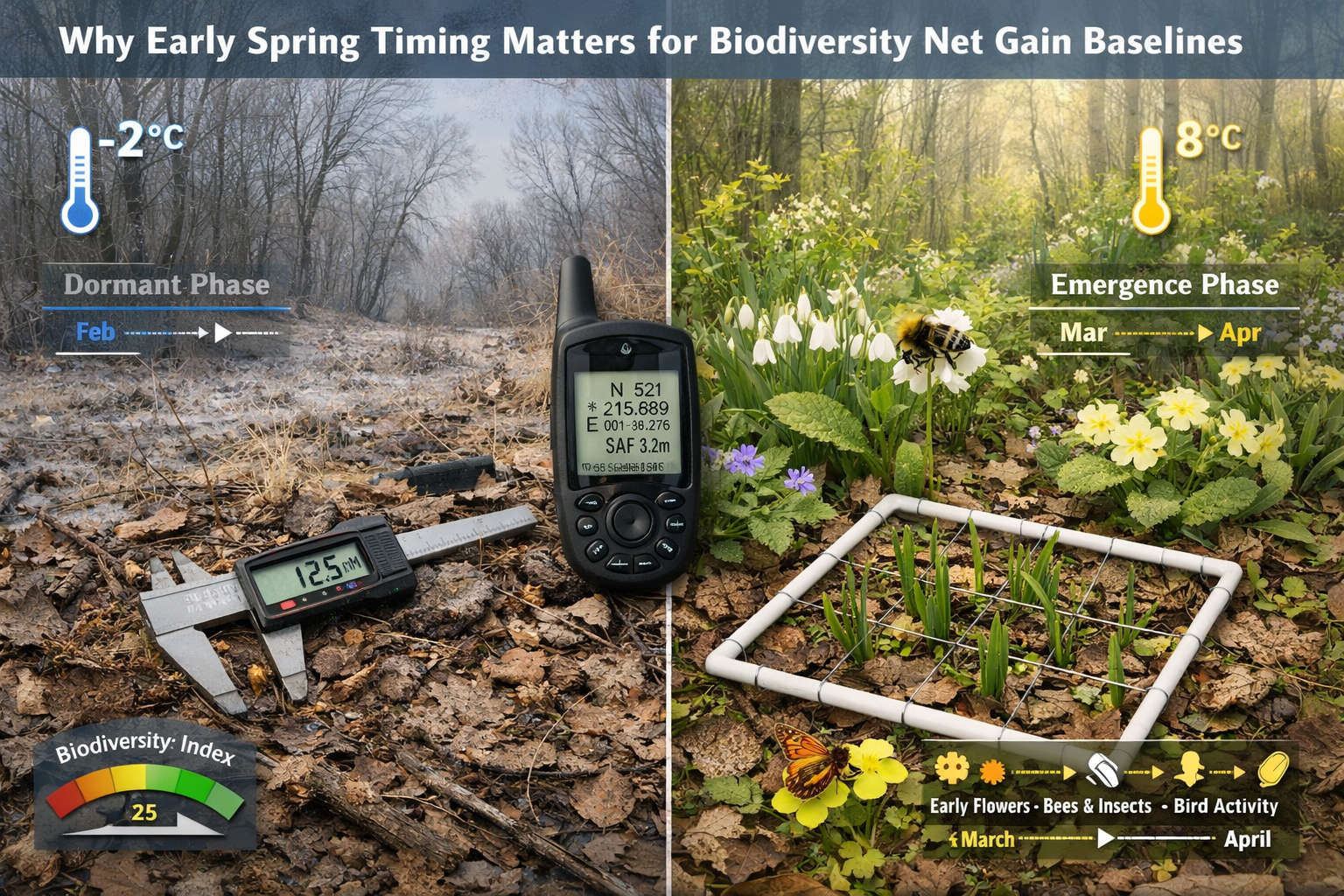
Why Early Spring Timing Matters for Biodiversity Net Gain Baselines
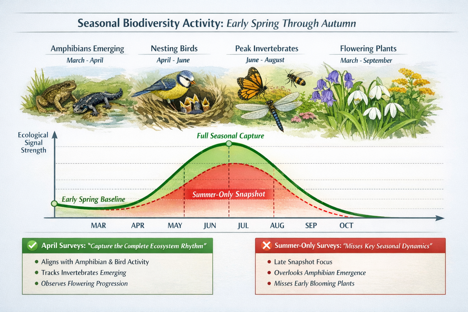
The foundation of any successful biodiversity net gain strategy rests on establishing accurate baseline conditions. However, baseline timing is critical for signal clarity—every future comparison depends on the starting point of monitoring[1]. Without early baselines established in spring 2026, weather-driven variation can be mistaken for long-term decline, and short-term disturbance can appear as recovery[1].
Capturing the Full Biological Activity Arc
Beginning monitoring in early spring rather than peak summer allows datasets to reflect the ecosystem's full rhythm. Spring captures the complete seasonal arc—from first emergence through peak summer and into seasonal decline—which is essential for distinguishing genuine change signals from seasonal noise[1].
Consider what happens when surveys begin in July or August:
- Missed early-season species: Spring-flowering plants, early-emerging invertebrates, and amphibian breeding activity go unrecorded
- Incomplete breeding bird data: Nesting activity and territorial behavior peak in April-June, not midsummer
- Skewed abundance metrics: Peak summer counts don't reflect population dynamics across the full active season
- Limited phenological data: Timing of biological events (flowering, emergence, migration) requires multi-month observation
"Data without strategic context is vulnerable to challenge. Monitoring framed with clear purpose is easier to defend and act upon compared to uncontextualized data."[1]
The Problem with Snapshot Surveys
One-off surveys provide detailed snapshots but fail to capture seasonal dynamics. In contrast, continuous monitoring reveals patterns, trends, and anomalies that static assessments miss[1]. This distinction becomes particularly important when developers need to demonstrate how to achieve 10% biodiversity net gain requirements.
Snapshot survey limitations:
| Survey Type | Strengths | Weaknesses |
|---|---|---|
| Single-visit snapshot | Quick, cost-effective, detailed species list | Misses seasonal variation, weather-dependent, no trend data |
| Multi-season continuous | Captures full activity patterns, reveals trends, weather-resilient | Higher resource investment, requires sustained commitment |
| Early spring baseline | Establishes complete annual cycle, enables accurate comparisons | Requires April start, weather-dependent timing |
Establishing Robust Early Spring Baselines: The 2026 Protocol Checklist
To optimize Early Spring Baselines in Biodiversity Surveys: Optimizing 2026 Field Protocols for Accurate Net Gain Metrics, biodiversity professionals should follow a systematic three-step approach recommended for 2026 monitoring launches[1].
Step 1: Clarify Monitoring Objectives Before Installation
Before deploying any survey equipment or scheduling field visits, define the specific purpose of baseline monitoring:
Baseline ecosystem health assessment:
- Document pre-development conditions
- Identify priority habitats and species
- Establish reference conditions for future comparison
- Support biodiversity impact assessments
Management evaluation:
- Measure effectiveness of habitat creation
- Track restoration progress
- Assess intervention outcomes
- Guide adaptive management decisions
Regulatory reporting:
- Demonstrate BNG compliance
- Provide evidence for planning conditions
- Support statutory credit calculations
- Document on-site versus off-site delivery options
Step 2: Evaluate Approaches Based on Purpose
Different monitoring objectives require different methodological approaches. The choice between a single moment in time versus a living dataset that evolves with the ecosystem fundamentally shapes data quality[1].
For robust 2026 baselines, prioritize:
✅ Multi-visit protocols covering April through September
✅ Standardized survey methods allowing year-to-year comparison
✅ Weather-contingent scheduling to avoid bias from extreme conditions
✅ Taxonomic breadth including plants, invertebrates, birds, mammals, and amphibians
✅ Habitat condition assessments using recognized metrics
✅ Photographic documentation establishing visual reference points
✅ GPS-mapped survey routes enabling precise replication
Step 3: Start Early to Monitor Full Seasonal Arc
The 2026 field season presents an optimal opportunity to establish comprehensive baselines. Early spring monitoring should commence in April 2026 to capture:
🌸 April (Early Spring):
- Amphibian breeding surveys (great crested newts, common frogs)
- Early flowering plants (primrose, lesser celandine, wood anemone)
- Breeding bird territory mapping (first visits)
- Emerging invertebrates (bumblebee queens, butterflies)
- Habitat condition baseline photography
🌿 May-June (Late Spring/Early Summer):
- Peak breeding bird activity (second and third visits)
- Flowering plant diversity surveys
- Invertebrate abundance monitoring
- Bat emergence surveys
- Reptile presence/absence surveys
☀️ July-August (Peak Summer):
- Maximum invertebrate diversity
- Late-flowering plant species
- Breeding bird confirmation visits
- Bat activity surveys
- Habitat structure assessments
🍂 September (Early Autumn):
- Late-season species recording
- Habitat condition reassessment
- Autumn flowering plants
- Migration activity
- Baseline completion documentation
Addressing Geographic Sampling Bias in 2026 Field Protocols
Even with optimal timing, Early Spring Baselines in Biodiversity Surveys: Optimizing 2026 Field Protocols for Accurate Net Gain Metrics can suffer from systematic geographic bias that undermines data reliability. Research on butterfly records revealed that approximately 80% of records occur within 1 kilometer of roads[2], creating systematic undersampling in remote areas.
The Road Proximity Problem
This undersampling bias disproportionately affects climate-sensitive populations in remote habitats—precisely the areas most important for understanding long-term ecological change[2]. For biodiversity surveyors establishing 2026 baselines, this creates several challenges:
Access-related sampling bias:
- Roadside habitats receive disproportionate survey effort
- Remote woodlands, wetlands, and uplands remain undersampled
- Edge effects from roads influence species composition
- True habitat quality in site interiors goes unmeasured
Undersampled land ownership categories:
- Tribal lands (permitting requirements)
- Bureau of Land Management areas (access restrictions)
- Military installations (security limitations)
- Private holdings (permission barriers)
- Remote mountain ranges (logistical challenges)
Strategies to Minimize Geographic Bias
To establish representative baselines for biodiversity net gain reports, surveyors should:
-
Stratify sampling across access gradients: Deliberately include sites at varying distances from roads and access points
-
Use remote sensing for preliminary habitat mapping: Early pilot analyses using remotely sensed datasets revealed new development in approximately 4% of surveyed areas since last field surveys[5], demonstrating the value of integrating remote sensing with ground-truthing
-
Establish permanent transects in site interiors: Create repeatable survey routes that extend beyond edge habitats into core areas
-
Document access limitations transparently: Record which areas couldn't be surveyed and explain why in baseline reports
-
Prioritize undersampled habitat types: Allocate extra effort to remote wetlands, dense woodlands, and steep terrain often avoided in convenience sampling
Integrating Technology and Traditional Methods in 2026 Surveys
The 2026 Global Horizon Scan published in Trends in Ecology & Evolution identified emerging issues including new AI tools for biodiversity assessment[3], signaling a shift toward technology-enhanced field protocols.
Remote Sensing and Ground-Truthing Integration
Modern baseline surveys should combine:
Remote sensing capabilities:
- Drone-based habitat mapping
- Satellite imagery change detection
- LiDAR vegetation structure analysis
- Thermal imaging for mammal surveys
- Multispectral analysis for plant health
Traditional field validation:
- Species-level identification
- Habitat condition assessment
- Behavioral observations
- Microhabitat characterization
- Soil and water sampling
This hybrid approach addresses the finding that remote sensing detected development changes in 4% of surveyed areas[5], while field surveys provide the species-level detail required for biodiversity net gain calculations.
Emerging Tools for 2026 Field Seasons
Recommended technology integration:
📱 Mobile data collection apps: Real-time data entry, GPS tagging, photo documentation, weather logging
🎤 Acoustic monitoring: Automated bat detectors, bird song recorders, amphibian call monitoring
📷 Camera traps: 24/7 mammal monitoring, minimal disturbance, temporal activity patterns
🔬 Environmental DNA (eDNA): Water sampling for aquatic species, soil sampling for invertebrates
🤖 AI-assisted identification: Automated species recognition from photos, sound analysis, pattern detection
Common Pitfalls in Spring Baseline Establishment
Even experienced surveyors can fall into traps that compromise baseline quality. Understanding these pitfalls helps optimize Early Spring Baselines in Biodiversity Surveys: Optimizing 2026 Field Protocols for Accurate Net Gain Metrics.
Timing Errors
❌ Starting too late: Beginning surveys in June misses critical spring emergence and breeding activity
❌ Single-season coverage: Assuming one year's data represents typical conditions when weather varies annually
❌ Weather-insensitive scheduling: Conducting surveys during unseasonable cold snaps or heat waves
❌ Ignoring phenological shifts: Not accounting for climate-driven changes in species activity timing
Methodological Inconsistencies
❌ Varying survey effort: Changing time spent, area covered, or methods between visits
❌ Observer bias: Different surveyors recording different species without calibration
❌ Incomplete habitat coverage: Missing microhabitats like ditches, hedgerows, or woodland edges
❌ Inadequate replication: Single transects or quadrats that don't capture site variability
Documentation Failures
❌ Poor spatial referencing: Vague location descriptions preventing accurate resurveys
❌ Missing metadata: No weather, time, or observer information recorded
❌ Insufficient photography: Lack of visual documentation for habitat condition
❌ Unclear methodology: Future surveyors can't replicate protocols from baseline reports
The Strategic Value of Early Spring Baselines for Stakeholders
Different stakeholders benefit from robust early spring baseline establishment in specific ways:
For Developers and Planners
Well-executed spring baselines provide:
- Defensible planning applications: Comprehensive data withstands scrutiny from planners evaluating BNG compliance
- Accurate metric calculations: Complete seasonal data improves biodiversity unit calculations
- Risk reduction: Early identification of protected species prevents costly delays
- Design optimization: Baseline insights inform how architects can solve BNG challenges
For Ecologists and Surveyors
Comprehensive spring protocols deliver:
- Professional credibility: Robust methodologies demonstrate technical competence
- Efficient resource allocation: Early planning prevents rushed surveys during peak season
- Data quality: Multi-season coverage provides statistical power for analysis
- Future-proofing: Well-documented baselines support long-term monitoring programs
For Landowners and Conservation Organizations
Strategic baseline timing enables:
- Habitat value documentation: Comprehensive species lists support biodiversity unit sales
- Management planning: Baseline data guides habitat enhancement decisions
- Funding applications: Robust data strengthens conservation grant proposals
- Long-term monitoring: Established protocols support adaptive management
Preparing for the 2026 Field Season: Practical Action Steps

With early spring 2026 approaching, biodiversity professionals should take immediate action to optimize baseline establishment.
January-February 2026: Planning Phase
✓ Secure site access permissions for all survey areas
✓ Recruit and train survey teams in standardized protocols
✓ Procure equipment including GPS units, cameras, identification guides
✓ Develop data management systems for efficient recording
✓ Review previous surveys if available to ensure comparability
✓ Schedule survey visits across April-September period
✓ Establish quality control procedures for data validation
March 2026: Pre-Survey Preparation
✓ Conduct reconnaissance visits to identify access routes and survey locations
✓ Set up remote monitoring equipment (camera traps, acoustic recorders)
✓ Calibrate observer teams with joint training sessions
✓ Finalize survey protocols with detailed methodology documentation
✓ Prepare field data sheets or mobile app templates
✓ Brief stakeholders on survey schedule and expected outputs
April-September 2026: Active Survey Period
✓ Execute monthly survey visits following standardized protocols
✓ Record comprehensive metadata for every survey event
✓ Take systematic photographs documenting habitat condition
✓ Download and backup data immediately after each visit
✓ Conduct preliminary analysis to identify data gaps
✓ Adjust protocols if needed while maintaining comparability
✓ Communicate progress to project stakeholders
October-December 2026: Analysis and Reporting
✓ Complete data validation and quality checks
✓ Conduct statistical analysis of seasonal patterns
✓ Calculate biodiversity metrics using appropriate tools
✓ Prepare baseline reports with clear methodology documentation
✓ Archive data and samples for future reference
✓ Plan next year's monitoring if ongoing surveys required
✓ Share findings with relevant stakeholders and databases
Conclusion: Building the Foundation for Measurable Conservation Outcomes
Early Spring Baselines in Biodiversity Surveys: Optimizing 2026 Field Protocols for Accurate Net Gain Metrics represents far more than a technical requirement—it establishes the foundation upon which all future conservation success will be measured. As the UK's mandatory Biodiversity Net Gain framework matures in 2026, the quality of baseline data will determine whether development projects deliver genuine ecological improvement or merely meet bureaucratic minimums.
Starting surveys in early spring captures the complete seasonal rhythm of ecosystems, from first emergence through peak activity and into seasonal decline. This comprehensive approach distinguishes real ecological change from seasonal variation, weather anomalies from long-term trends, and genuine recovery from temporary fluctuations. Without this temporal depth, even the most detailed snapshot surveys risk misinterpreting ecosystem condition.
The three-step protocol—clarifying objectives, evaluating approaches based on purpose, and starting early to monitor full seasonal arcs—provides a practical framework for establishing robust baselines. Combined with strategies to minimize geographic sampling bias, integrate emerging technologies with traditional field methods, and avoid common methodological pitfalls, this approach delivers defensible data that withstands regulatory scrutiny and supports adaptive management.
For developers, planners, ecologists, and landowners navigating the complexities of biodiversity net gain requirements, investing in comprehensive early spring baselines pays dividends throughout project lifecycles. Well-documented baseline conditions enable accurate metric calculations, inform design optimization, reduce regulatory risk, and provide the evidence base for demonstrating genuine conservation outcomes.
Next Steps for 2026
As the 2026 field season approaches, take action now:
- Review your current baseline protocols against the checklist provided in this article
- Schedule planning meetings for January-February 2026 to prepare survey teams
- Secure necessary permissions for site access across the full survey period
- Invest in appropriate technology to enhance data quality and efficiency
- Establish partnerships with experienced biodiversity surveyors who understand BNG requirements
- Document your methodology thoroughly to enable future comparisons
- Begin surveys in April 2026 to capture the complete seasonal arc
The baseline you establish in spring 2026 will serve as the reference point for years of future monitoring, management decisions, and regulatory reporting. Make it count by starting early, surveying comprehensively, and documenting thoroughly. The future of biodiversity net gain depends on the quality of data collected in the coming months.
References
[1] Why Monitor Biodiversity In 2026 – https://evolito.earth/stories/why-monitor-biodiversity-in-2026
[2] Spring 2026 Arrives Early For Butterflies – https://peecnature.org/spring-2026-arrives-early-for-butterflies/
[3] Whats Next For Biodiversity Conservation Insights From The 2026 Horizon Scan – https://www.unep-wcmc.org/en/news/whats-next-for-biodiversity-conservation-insights-from-the-2026-horizon-scan
[5] Natureserve Highlights Growing Biodiversity Risks Amid Shifting Conservation – https://www.natureserve.org/news-releases/natureserve-highlights-growing-biodiversity-risks-amid-shifting-conservation
