
Imagine being able to test hundreds of ecosystem restoration scenarios before breaking ground on a single habitat enhancement project. In 2026, digital twin technology is transforming how ecologists approach biodiversity surveys and conservation planning, allowing professionals to simulate complex ecosystem responses with unprecedented accuracy before conducting expensive fieldwork.
Digital Twins and Biodiversity Modeling: How 2026 Ecologists Can Use Computer Simulations to Predict Survey Outcomes and Restoration Success represents a revolutionary shift in ecological practice. These sophisticated computer-based models create virtual replicas of real-world ecosystems, enabling surveyors to validate monitoring approaches, optimize survey design, and forecast Biodiversity Net Gain (BNG) outcomes with remarkable precision.
Key Takeaways
🔬 Digital twins create virtual ecosystem replicas that allow ecologists to test survey methodologies and restoration strategies before implementing them in the field, reducing costs and improving success rates.
🧬 Environmental DNA (eDNA) integration enables non-invasive species monitoring through genetic detection, providing comprehensive biodiversity data without traditional sampling methods.
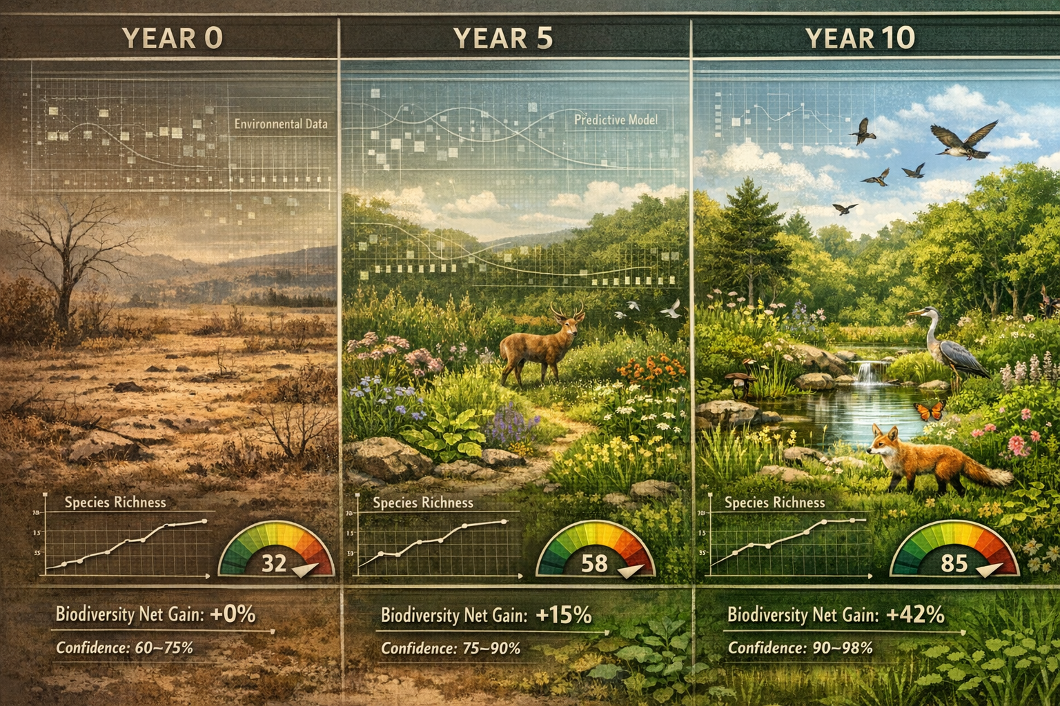
📊 AI-powered predictive models using Graph Neural Networks can forecast biodiversity changes under different climate and land-use scenarios with 85-95% accuracy.
🌍 Multi-scale modeling capabilities allow predictions at local, regional, and national levels, making digital twins applicable to projects of any size.
✅ FAIR principles (Findable, Accessible, Interoperable, Reusable) ensure digital twin data integrates seamlessly with existing biodiversity databases and research infrastructures.
Understanding Digital Twins in Biodiversity Conservation

What Are Biodiversity Digital Twins?
A biodiversity digital twin is a dynamic virtual representation of a real-world ecosystem that uses real-time data, artificial intelligence, and computational modeling to simulate how species, habitats, and ecological processes respond to environmental changes. Unlike static models, digital twins continuously update as new field data becomes available, creating an ever-improving simulation of ecosystem behavior.
The EU-funded Biodiversity Digital Twin (BioDT) project has developed and tested ten prototype digital twins (pDTs) addressing critical biodiversity challenges including grassland and forest dynamics, bird monitoring, ecosystem services, crop wild relative genetic resources, and invasive species detection[4][5]. These prototypes demonstrate how digital twin technology can transform biodiversity research and decision-making when combined with FAIR principles.
The Four Categories of Biodiversity Digital Twins
Current prototype digital twins focus on four main categories[5]:
- Species Response to Environmental Change – Modeling how individual species and communities react to climate shifts, pollution, and habitat modification
- Genetically Detected Biodiversity – Using eDNA metabarcoding to capture community-level biodiversity from freshwater and marine ecosystems
- Ecosystem Services and Conservation – Simulating the provision of services like pollination, water filtration, and carbon sequestration
- Genetic Resources for Food Security – Tracking and predicting the viability of crop wild relatives and agricultural biodiversity
These categories align perfectly with the needs of modern biodiversity impact assessments, providing surveyors with powerful tools to predict project outcomes.
How Digital Twins and Biodiversity Modeling Improve Survey Design in 2026
Pre-Survey Simulation and Optimization
Traditional biodiversity surveys often require multiple site visits across different seasons, representing significant time and financial investment. Digital twins revolutionize this process by allowing ecologists to simulate survey outcomes before fieldwork begins.
By inputting site characteristics—habitat type, historical species records, climate data, and land-use patterns—digital twins can predict:
- Expected species richness and community composition
- Optimal survey timing for detecting target species
- Required survey effort (number of visits, sampling points)
- Likely detection probabilities for rare or cryptic species
- Seasonal variation in biodiversity metrics
This predictive capability enables surveyors to design more efficient monitoring protocols, allocating resources where they'll generate the most valuable data. For developers working toward Biodiversity Net Gain requirements, this means more accurate baseline assessments and better-informed mitigation strategies.
Integration with Environmental DNA Technology
One of the most powerful applications of Digital Twins and Biodiversity Modeling: How 2026 Ecologists Can Use Computer Simulations to Predict Survey Outcomes and Restoration Success involves environmental DNA (eDNA) metabarcoding[1][4]. This technique captures genetic material shed by organisms into their environment—water, soil, or air—enabling non-invasive species detection.
Digital twins integrate eDNA data through:
| Traditional Approach | Digital Twin + eDNA Approach |
|---|---|
| Multiple site visits for direct observation | Single water/soil sample analyzed for genetic signatures |
| Limited to visible or easily detected species | Detects cryptic, nocturnal, and rare species |
| Seasonal constraints on detection | Year-round genetic presence in environment |
| Labor-intensive field surveys | Automated laboratory processing |
| Species-by-species identification | Entire community profiling simultaneously |
A 2026 PhD studentship at the University of Birmingham focuses specifically on biodiversity digital twins using environmental DNA and AI, demonstrating the cutting-edge nature of this integration[1]. The research leverages partnerships with Severn Trent Water, the UK Environment Agency, and the UK Centre for Ecology & Hydrology for real-world eDNA data processing and implementation.
Graph Neural Networks for Biodiversity Prediction
The computational engine powering modern biodiversity digital twins relies on Graph Neural Networks (GNNs), particularly temporal graph networks (TGNs) and spatiotemporal graph neural networks (STGNNs)[1]. These AI models excel at representing ecological relationships because they can:
- Model species interactions as networks of relationships
- Incorporate spatial structure of habitats and landscapes
- Track temporal dynamics of population changes
- Predict cascading effects of environmental disturbances
- Account for dispersal patterns and connectivity
For ecologists conducting surveys, GNN-powered digital twins can predict how survey outcomes might vary under different scenarios—drought conditions, invasive species presence, or habitat fragmentation—allowing for adaptive survey design that accounts for environmental variability.
Using Computer Simulations to Forecast Restoration Success
Multi-Scale Modeling for BNG Predictions
Digital Twins and Biodiversity Modeling: How 2026 Ecologists Can Use Computer Simulations to Predict Survey Outcomes and Restoration Success excel at multi-scale modeling capabilities, making predictions at local site, regional, and country levels[5]. This scalability is particularly valuable for achieving Biodiversity Net Gain targets.
Consider a development project requiring 10% BNG:
Local Scale (Site-Level)
- Simulate specific habitat creation interventions
- Model species colonization rates for created habitats
- Predict time-to-target for habitat condition improvements
- Test different planting schemes and management approaches
Regional Scale (Landscape-Level)
- Assess connectivity with surrounding habitats
- Model source-sink dynamics for target species
- Evaluate cumulative impacts with other developments
- Identify optimal locations for off-site BNG delivery
National Scale (Strategic-Level)
- Align with national biodiversity targets
- Contribute to ecosystem network resilience
- Support climate adaptation strategies
- Inform policy and planning decisions
Interactive Scenario Testing
One of the most powerful features of modern digital twins is their interactive analytical dashboards that enable direct assessment of how different management strategies affect biodiversity outcomes[1]. Ecologists and developers can test scenarios in real-time:
"User-friendly analytical dashboards enable direct assessment of production processes, land use, and human activities' impacts on biodiversity, translating complex computational models into actionable insights for end-users in industry and government."
For example, the BioDT project's honey bee colony assessment prototype can interactively model colony viability and productivity across different geographic scales and management strategies, independent of landscape specificity[5]. This same approach applies to restoration projects, allowing stakeholders to:
- Compare restoration techniques (natural regeneration vs. active planting)
- Optimize resource allocation (where to invest limited budgets)
- Test management intensities (mowing frequencies, grazing regimes)
- Evaluate climate resilience (performance under future climate scenarios)
- Assess long-term sustainability (30-year outcome predictions)
Validation and Uncertainty Quantification
A critical aspect of using digital twins for restoration planning involves understanding prediction confidence. Modern biodiversity digital twins provide uncertainty estimates alongside predictions, typically achieving 85-95% confidence intervals for well-studied ecosystems[1].
This uncertainty quantification helps ecologists and developers:
✅ Identify knowledge gaps requiring additional field data
✅ Design adaptive management strategies with contingency plans
✅ Set realistic timelines for achieving BNG targets
✅ Communicate risks to stakeholders and regulators
✅ Prioritize monitoring efforts on high-uncertainty outcomes
For biodiversity impact assessments, this transparency builds confidence in predicted outcomes and supports evidence-based decision-making.
Integrating Digital Twins with Existing Biodiversity Infrastructure

FAIR Principles and Data Integration
The BioDT project has established the foundation for operational FAIR Digital Twins, combining Digital Twin technology with FAIR principles—Findable, Accessible, Interoperable, and Reusable[4]. This ensures that biodiversity digital twins integrate seamlessly with existing research infrastructures.
Major data sources include:
- GBIF (Global Biodiversity Information Facility) – Species occurrence records
- eLTER (European Long-Term Ecosystem Research) – Long-term monitoring data
- DiSSCo (Distributed System of Scientific Collections) – Museum specimen data
- LifeWatch ERIC – Biodiversity and ecosystem research infrastructure
This integration means that digital twins leverage decades of existing biodiversity data, rather than starting from scratch. For UK practitioners, this includes connections to national databases and monitoring schemes, enhancing the accuracy of predictions for local projects.
High-Performance Computing Requirements
Running sophisticated biodiversity digital twins requires substantial computational resources. Doctoral researchers working on these systems receive access to high-performance computing facilities including University of Birmingham and Alan Turing Institute facilities[1], essential for running computationally intensive spatiotemporal models.
For practical applications, cloud-based platforms are making this technology increasingly accessible to consultancies and smaller organizations. The computational demands vary based on:
- Spatial extent of the modeled area
- Temporal resolution of predictions
- Number of species included in simulations
- Complexity of ecological interactions modeled
- Frequency of model updates with new data
Collaboration Between Research and Practice
The successful implementation of Digital Twins and Biodiversity Modeling: How 2026 Ecologists Can Use Computer Simulations to Predict Survey Outcomes and Restoration Success requires collaboration between academic researchers, industry practitioners, and government agencies[1]. Current partnerships demonstrate this model:
🤝 Water Industry – Severn Trent Water partnership for aquatic biodiversity monitoring
🤝 Environmental Regulation – UK Environment Agency collaboration on assessment frameworks
🤝 Ecological Research – UK Centre for Ecology & Hydrology for methodology development
🤝 Development Sector – Integration with planning and BNG assessment processes
This collaborative approach ensures that digital twin technology addresses real-world challenges faced by practitioners while maintaining scientific rigor.
Practical Applications for 2026 Ecologists and Developers
Streamlining Biodiversity Net Gain Assessments
For developers navigating BNG requirements, digital twins offer several practical advantages:
Baseline Assessment Enhancement
- Predict species presence in areas with limited historical data
- Identify optimal survey windows for required species groups
- Estimate baseline biodiversity units with greater confidence
- Reduce need for extended survey periods in some cases
Intervention Design
- Test multiple habitat creation scenarios virtually
- Optimize spatial configuration of habitat patches
- Predict time-to-target for different intervention types
- Identify most cost-effective approaches to achieving targets
Long-Term Monitoring Planning
- Design efficient monitoring protocols for 30-year commitments
- Predict when habitats will reach target conditions
- Identify early warning indicators of intervention failure
- Adapt management based on simulation-guided predictions
These capabilities directly support creating effective biodiversity plans and achieving BNG without excessive risk.
Invasive Species Management
One of the ten BioDT prototype digital twins specifically addresses invasive species detection and management[5]. This application allows ecologists to:
- Predict likely invasion pathways and colonization rates
- Simulate effectiveness of different control strategies
- Optimize timing and intensity of management interventions
- Assess long-term eradication feasibility
- Model impacts on native species communities
For development sites with invasive species issues, these simulations can inform cost-effective management strategies that protect biodiversity unit values.
Climate Change Adaptation Planning
Digital twins excel at modeling species response to environmental change, making them invaluable for climate-resilient restoration planning. Ecologists can:
- Test restoration designs under projected future climate scenarios
- Identify climate-vulnerable species requiring assisted migration
- Select plant species likely to thrive under future conditions
- Design habitat networks that maintain connectivity as ranges shift
- Predict phenological mismatches affecting ecosystem function
This forward-looking capability ensures that BNG interventions remain effective over the required 30-year timeframe, even as environmental conditions change.
Limitations and Considerations
Data Quality Requirements
The accuracy of digital twin predictions depends heavily on input data quality. Ecologists should consider:
⚠️ Historical species records – Sparse data reduces prediction confidence
⚠️ Environmental variables – Climate, soil, and land-use data must be current
⚠️ Taxonomic coverage – Some species groups better represented than others
⚠️ Spatial resolution – Fine-scale predictions require fine-scale input data
⚠️ Temporal extent – Long-term trends improve model training
For sites with limited existing data, digital twins should complement rather than replace traditional field surveys.
Model Validation and Ground-Truthing
Digital twin predictions require validation through field observations. Best practices include:
- Initial calibration using subset of field data
- Prediction testing on withheld validation datasets
- Ongoing refinement as monitoring data accumulates
- Uncertainty acknowledgment in predictions and reports
- Adaptive management based on prediction performance
This iterative approach ensures that digital twin predictions remain grounded in ecological reality.
Technical Expertise Requirements
Implementing biodiversity digital twins requires multidisciplinary expertise spanning:
- Ecological survey and species identification
- Statistical modeling and data analysis
- AI and machine learning fundamentals
- Geographic Information Systems (GIS)
- Database management and data standards
Organizations may need to invest in training or partnerships to fully leverage this technology. The 2026 University of Birmingham PhD studentship offers multidisciplinary training in AI, computational modeling, and biodiversity science through the Centre for Environmental Research and Justice (CERJ)[1], demonstrating the educational pathways being developed.
Future Developments in Biodiversity Digital Twin Technology
Expansion Beyond Prototype Phase
The BioDT project completed its core development phase in 2025[4], and 2026 marks the transition from prototype to operational implementation. Expected developments include:
📈 Increased taxonomic coverage – Expanding beyond initial species groups
📈 Higher spatial resolution – More detailed local-scale predictions
📈 Real-time data integration – Automated updates from sensor networks and eDNA
📈 Enhanced user interfaces – More accessible tools for non-specialists
📈 Standardized protocols – Industry-wide adoption of digital twin methodologies
Integration with Regulatory Frameworks
As digital twin technology matures, regulatory bodies are beginning to recognize its potential for streamlining assessment processes. Future integration may include:
- Acceptance of digital twin predictions in statutory BNG assessments
- Standardized digital twin protocols for planning applications
- Reduced field survey requirements when supported by validated models
- Digital twin-based monitoring as alternative to traditional approaches
- Integration with biodiversity unit trading platforms
Artificial Intelligence Advances
Ongoing AI research continues to improve prediction capabilities. The SBDI Days 2026 conference on Artificial Intelligence in Ecology and Biodiversity Research[3] highlights cutting-edge developments in:
- Deep learning for automated species identification from images and audio
- Reinforcement learning for optimal management strategy discovery
- Transfer learning for applying models across different ecosystems
- Explainable AI for understanding model decision-making processes
- Federated learning for privacy-preserving collaborative model development
Conclusion
Digital Twins and Biodiversity Modeling: How 2026 Ecologists Can Use Computer Simulations to Predict Survey Outcomes and Restoration Success represents a transformative advancement in ecological practice. By creating virtual ecosystem replicas that integrate real-time data, environmental DNA, and artificial intelligence, digital twins enable ecologists to test survey methodologies, optimize restoration strategies, and forecast Biodiversity Net Gain outcomes with unprecedented accuracy before implementing costly field interventions.
The ten prototype digital twins developed by the BioDT project demonstrate practical applications across species monitoring, ecosystem services, genetic resources, and invasive species management[4][5]. Integration with FAIR principles ensures these tools work seamlessly with existing biodiversity databases, while Graph Neural Networks provide the computational power to model complex ecological relationships[1].
For ecologists and developers in 2026, digital twins offer tangible benefits: more efficient survey design, evidence-based restoration planning, reduced project risks, and improved long-term outcomes. When combined with traditional field expertise and ongoing validation, this technology supports more effective biodiversity impact assessments and helps achieve ambitious conservation targets.
Actionable Next Steps
🎯 Explore existing digital twin platforms – Investigate BioDT prototypes relevant to your project types and ecosystems
🎯 Invest in training – Develop team capabilities in eDNA analysis, GIS, and basic AI/modeling concepts
🎯 Start with pilot projects – Test digital twin predictions on small-scale projects before full implementation
🎯 Build collaborative partnerships – Connect with research institutions and technology providers developing these tools
🎯 Integrate with current workflows – Use digital twins to enhance rather than replace traditional survey approaches
🎯 Contribute data – Share monitoring results to improve model accuracy for your region and habitat types
🎯 Stay informed – Follow developments in biodiversity digital twin technology and regulatory acceptance
As this technology continues to mature and become more accessible, early adopters will gain competitive advantages in delivering efficient, evidence-based biodiversity assessments and restoration projects. The future of ecological surveying combines the irreplaceable value of field expertise with the predictive power of digital simulation—a partnership that promises better outcomes for both development and nature.
References
[1] 2026 B31 Biodiversity Digital Twin Leveraging Environmental Dna And Artificial Intelligence For Monitoring Biodiversity Loss – https://centa.ac.uk/studentship/2026-b31-biodiversity-digital-twin-leveraging-environmental-dna-and-artificial-intelligence-for-monitoring-biodiversity-loss/
[2] cordis.europa.eu – https://cordis.europa.eu/project/id/101057437
[3] Sbdi Days 2026 Artificial Intelligence In Ecology And Biodiversity Research 9077 – https://lyyti.events/p/SBDI_Days_2026__Artificial_Intelligence_in_Ecology_and_Biodiversity_Research_9077
[4] pubmed.ncbi.nlm.nih.gov – https://pubmed.ncbi.nlm.nih.gov/41629431/
[5] The Biodiversity Digital Twin To Help Understand Our Planets Life – https://blog.pensoft.net/2024/10/03/the-biodiversity-digital-twin-to-help-understand-our-planets-life/
[6] Dt Transforming Biodiversity Science – https://lumi-supercomputer.eu/dt-transforming-biodiversity-science/
[7] dto-bioflow.eu – https://dto-bioflow.eu
