

Roads, railways, and pipelines in England collectively span tens of thousands of kilometres, and every new or upgraded scheme is now legally required to deliver a minimum 10% Biodiversity Net Gain under the Environment Act 2021. Yet the standard BNG toolkit was designed around compact development plots, not corridors that may run for 50, 100, or even 300 kilometres across dozens of landholdings, local authority boundaries, and contrasting ecological zones. Adapting survey methods, sampling design, and metric calculations for these schemes is one of the most technically demanding challenges facing ecology and biodiversity surveyors in 2026.
This article addresses exactly that challenge. It explains how practitioners can adapt their methods, sampling design, and BNG calculations for long, linear schemes, and how to do so in a way that is defensible, proportionate, and practically deliverable. For a grounding in what biodiversity net gain actually requires at the project level, that context is essential before scaling up to the landscape.
Key Takeaways
- Linear infrastructure schemes require bespoke survey sampling designs because standard plot-based BNG protocols cannot capture habitat variability across long corridors.
- Stratified random sampling, segmentation by habitat type, and tiered survey effort are the most defensible approaches for roads, rail, and pipelines.
- Jurisdictional complexity, multiple local planning authorities, landowners, and consenting regimes, demands early coordination of survey scope and metric reporting.
- On-site habitat creation along the corridor and off-site biodiversity units in the wider landscape can both contribute to the required 10% gain, but each requires careful spatial planning.
- Robust baseline data collected at the landscape scale directly reduces financial and regulatory risk throughout the consenting process.
Why Standard BNG Survey Approaches Fall Short for Linear Schemes
A typical residential development might cover two to five hectares. An ecologist can walk the entire site in a morning, complete a Phase 1 habitat survey, and produce a Biodiversity Metric calculation with high confidence. A new road bypass or gas pipeline is a fundamentally different proposition.
The core problems are threefold:
-
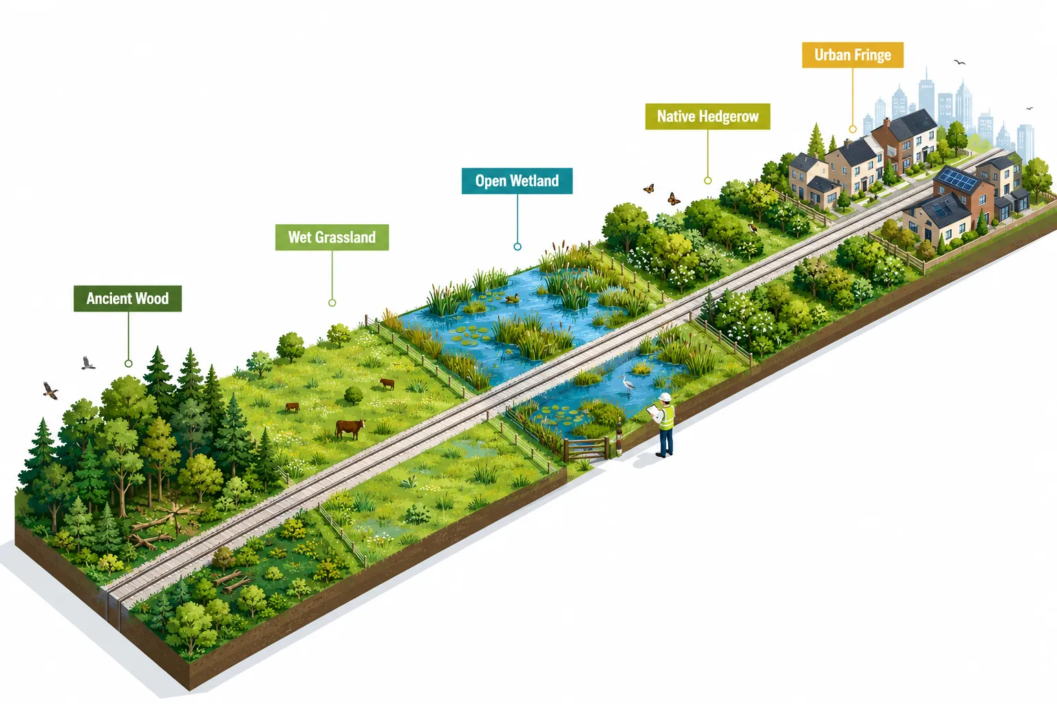
Spatial scale: A 30-kilometre pipeline corridor may cross ancient woodland, lowland meadow, floodplain grazing marsh, improved grassland, and urban brownfield within a single scheme. Each habitat type has different survey requirements, different condition assessment criteria, and different unit values in the DEFRA Biodiversity Metric.
-
Temporal variability: Surveys conducted at one end of a long corridor in spring may not be comparable to those conducted at the other end in summer. Phenological differences affect what is detectable and what condition scores are assigned.
-
Ownership fragmentation: A single pipeline may cross 200 or more individual landholdings. Access agreements, survey timing, and data management all become logistical challenges that have no equivalent in standard development ecology.
Understanding what is in a biodiversity net gain assessment for a standard project is the necessary starting point, but linear infrastructure demands that every element of that assessment be rescaled and redesigned.
The Regulatory Context in 2026
The mandatory BNG requirement under the Town and Country Planning Act (as amended by the Environment Act 2021) applies to most nationally significant infrastructure projects (NSIPs) through the Development Consent Order process, as well as to smaller linear schemes determined at local authority level. The Infrastructure Planning (Environmental Impact Assessment) Regulations 2017 also require Habitats Regulations Assessment where schemes affect European Protected Sites. This layered regulatory environment means surveyors must design protocols that satisfy multiple consenting authorities simultaneously.
"The Biodiversity Metric was not designed to fail on linear schemes, but it was not designed specifically for them either. Surveyors who treat a 100-kilometre road scheme like a large housing site will produce data that is neither accurate nor defensible."
Survey Protocols for Linear Infrastructure and Biodiversity Net Gain at the Landscape Scale
Designing a survey protocol for a linear scheme requires decisions at three levels: strategic (what to survey and where), tactical (how to survey each habitat type), and operational (how to manage data across the corridor). Each level must be addressed explicitly in the survey method statement submitted to the consenting authority.
Strategic Level: Segmentation and Stratified Sampling
The first task is to divide the corridor into ecologically meaningful segments. This is not arbitrary, segments should reflect genuine changes in habitat type, landscape character, or ecological sensitivity. A useful segmentation framework uses the following criteria:
- National Character Areas (NCAs): Natural England's NCA boundaries often correspond to meaningful shifts in underlying geology, soils, and therefore habitat type. Segment boundaries aligned with NCAs are defensible and familiar to planning ecologists.
- Designated site proximity: Any segment within 500 metres of a Site of Special Scientific Interest (SSSI), Local Wildlife Site, or Ancient Woodland should be treated as a distinct high-sensitivity segment requiring enhanced survey effort.
- Land use transitions: Transitions from agricultural to semi-natural land, or from rural to urban fringe, should trigger new segment boundaries.
Once segments are defined, a stratified random sampling design is applied within each. This means:
| Habitat Category | Minimum Sample Coverage | Recommended Survey Method |
|---|---|---|
| Semi-natural grassland | 20% of total area | NVC community survey, DEFRA condition assessment |
| Woodland (all types) | 100% Phase 1, 25% Phase 2 | Extended Phase 1, NVC W-communities |
| Hedgerows | 100% | Hedgerow Survey Handbook protocol |
| Watercourses | 100% within 50m buffer | River Habitat Survey, SSSI condition criteria |
| Improved grassland | 10% of total area | Phase 1 with condition scoring |
| Urban/brownfield | 100% | Phase 1 with invertebrate scoping |
This tiered approach ensures survey effort is proportionate to ecological value, a principle explicitly supported by Natural England's BNG guidance and by the key planning considerations around biodiversity net gain that local authorities increasingly apply to linear schemes.
Tactical Level: Habitat-Specific Survey Methods
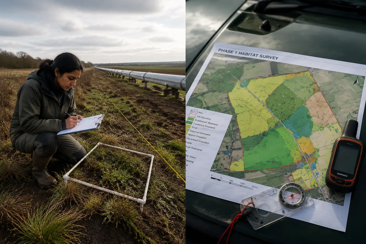
Grasslands present the greatest challenge on linear schemes because their condition scores drive the largest swings in biodiversity unit calculations. A field that scores "poor" rather than "moderate" condition under the DEFRA Metric may lose 30-40% of its unit value. On a scheme crossing 50 hectares of grassland, that difference can amount to hundreds of biodiversity units and significant financial liability. Full NVC surveys across all grassland are rarely proportionate, but a stratified approach, full NVC on a 20% random sample, extended Phase 1 on the remainder, provides a statistically defensible baseline.
Woodland requires particular care because the Metric treats different woodland types (ancient semi-natural, plantation on ancient woodland sites, secondary woodland) very differently. On a long corridor, it is common to encounter all three within a few kilometres. Each must be mapped and assessed separately. Ancient woodland indicators recorded during Phase 2 surveys can shift a woodland parcel from a low unit value to a high one, fundamentally changing the impact calculation.
Watercourses intersected by roads, rail, or pipelines are subject to both BNG requirements and separate Water Framework Directive obligations. River Habitat Survey (RHS) should be conducted at all crossing points, and the results fed into both the BNG metric and the Water Framework Directive compliance assessment. This dual-use data collection is efficient and reduces the total number of survey visits required.
Protected species surveys, great crested newts, bats, water voles, white-clawed crayfish, must be scoped and timed to coincide with BNG baseline surveys wherever possible. Integrated survey programmes reduce access burden on landowners and improve data consistency.
Operational Level: Data Management Across the Corridor
A 100-kilometre scheme may generate data from 50 or more individual survey visits, conducted by multiple ecologists over two or three survey seasons. Without a robust data management framework, the resulting baseline will be inconsistent and potentially unchallengeable.
Best practice operational protocols include:
- A single, version-controlled GIS database holding all habitat polygons, condition scores, and survey metadata
- Standardised field recording forms aligned directly to DEFRA Metric input requirements
- A named lead ecologist responsible for quality-assuring all condition assessments before they are entered into the Metric
- A clear audit trail showing which surveyor assessed each polygon, on which date, and under what weather conditions
- Photographic records georeferenced to each habitat polygon
These protocols are not bureaucratic overhead, they are the foundation of a defensible BNG calculation. When a planning inspector or Natural England officer challenges a condition score, the ability to produce a complete audit trail is what separates a robust assessment from a vulnerable one.
Calculating BNG Across Multiple Jurisdictions and Ownerships
The calculation of biodiversity units for a linear scheme is not simply a matter of running the DEFRA Metric once. Where a scheme crosses multiple local planning authority (LPA) areas, each LPA may require its own Metric output, its own biodiversity gain plan, and its own monitoring and reporting arrangements. For nationally significant infrastructure projects determined by the Planning Inspectorate, a single consolidated Metric is more appropriate, but it must still demonstrate compliance with the policies of each affected LPA.
Apportioning Impacts and Gains Along the Corridor
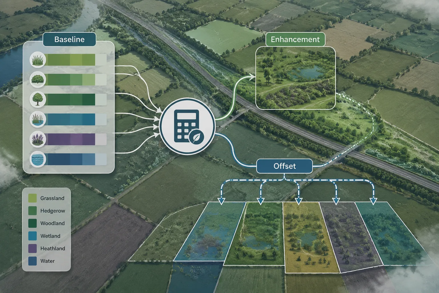
The standard approach is to calculate the net position (units lost minus units gained) for each defined segment of the corridor, then aggregate to a whole-scheme total. This allows the consenting authority to see both the overall net gain position and the distribution of impacts and gains along the route.
Where the scheme produces a net loss in one segment (for example, where it crosses a high-value ancient woodland), that loss must be compensated either by enhanced gains elsewhere on the corridor or by off-site biodiversity units. The spatial relationship between loss and gain matters: most LPAs expect losses to be compensated within the same broad landscape character area where possible.
For guidance on how on-site and off-site delivery options interact, the detailed analysis of biodiversity net gain off-site versus on-site delivery is directly relevant to linear scheme planning.
On-Site Opportunities Along Linear Corridors
Linear infrastructure schemes offer significant on-site BNG opportunities that are often underestimated at the design stage. These include:
- Verge and embankment creation: Road and rail embankments seeded with native wildflower mixes can create substantial areas of species-rich grassland. A dual-carriageway bypass with 10 kilometres of embankments may create 15-20 hectares of new grassland habitat.
- Habitat connectivity features: Underpasses, green bridges, and culverts designed for wildlife movement also function as new or enhanced habitat.
- Riparian buffer strips: Pipeline easements running parallel to watercourses can be managed as riparian buffer strips, creating linear wetland habitat with high unit values.
- Woodland planting: Compensatory woodland planting within the scheme boundary, designed to connect existing woodland blocks, can generate high unit values while also delivering landscape-scale connectivity benefits.
The key principle is that on-site habitat creation should be designed into the scheme from the earliest stages, not retrofitted once the engineering layout is fixed. Ecologists working on linear schemes should engage with design teams at the options appraisal stage, not just at the Environmental Impact Assessment stage.
Off-Site Biodiversity Units and Habitat Banking
Where on-site gains are insufficient to achieve the required 10% net gain, off-site biodiversity units must be secured. For linear schemes, this raises a specific spatial challenge: the off-site units should ideally be located in the same NCA or local nature recovery network area as the impact they are compensating. A scheme crossing five NCAs may therefore need to secure off-site units in five different geographic areas.
Habitat banks registered on the national biodiversity gain sites register are the most straightforward source of off-site units, but availability varies significantly by region. In areas where registered habitat banks are scarce, developers may need to establish bespoke off-site habitat creation agreements with landowners. Understanding the costs of biodiversity units and statutory credits is essential for project budget planning at this stage.
For schemes where off-site unit procurement is complex, achieving biodiversity net gain without the risk requires early engagement with specialist BNG advisors who understand both the ecological and commercial dimensions of habitat banking.
Monitoring, Reporting, and Long-Term Management
BNG is not a one-time calculation, it is a 30-year commitment. For linear infrastructure schemes, this creates long-term obligations that must be built into the scheme's environmental management framework from the outset.
Monitoring requirements for linear schemes typically include:
- Annual condition assessments of created and enhanced habitats for the first five years
- Five-yearly full condition surveys for the remaining 25 years of the management period
- Reporting to each relevant LPA (or to the Planning Inspectorate for NSIPs) against the agreed biodiversity gain plan
- Adaptive management provisions allowing habitat management to be adjusted if condition targets are not being met
The monitoring programme should be designed to use the same survey methods and condition criteria as the baseline survey. This ensures that changes in condition can be detected reliably and attributed to management interventions rather than methodological differences.
Ecologists advising on linear schemes should also be aware that planning your project with biodiversity net gain in mind from the earliest stages significantly reduces the cost and complexity of both the survey programme and the long-term monitoring commitment.
Conclusion
Linear infrastructure and biodiversity net gain at the landscape scale represent one of the most technically demanding intersections in contemporary development ecology. The survey protocols, sampling designs, and metric calculations required for roads, rail, and pipelines cannot simply be scaled up from standard plot-based approaches, they require bespoke frameworks that account for habitat variability, jurisdictional complexity, and the practical realities of surveying across long corridors and multiple ownerships.
Actionable next steps for ecologists and project teams working on linear schemes in 2026:
- Begin segmentation and scoping at the options appraisal stage, not at EIA stage.
- Design a stratified random sampling framework that allocates survey effort proportionate to habitat sensitivity.
- Establish a single GIS-based data management system before fieldwork begins.
- Engage with local planning authorities and Natural England early to agree the scope and methodology of the BNG assessment.
- Identify on-site habitat creation opportunities in the design team's earliest layouts.
- Scope off-site unit requirements by NCA area and begin habitat bank procurement well ahead of the planning application.
- Build a 30-year monitoring programme into the project's environmental management plan from day one.
The ecology profession has the methods and the knowledge to deliver genuine biodiversity gains from linear infrastructure. The challenge is applying them at a scale and complexity that standard practice has not yet fully addressed, and doing so in a way that is rigorous, transparent, and ultimately beneficial to the landscapes these schemes pass through.