
Recent software advances now enable comprehensive quantification of 11 distinct ecosystem stability indicators from time series data, fundamentally transforming how surveyors verify biodiversity net gain compliance[2]. This breakthrough shifts BNG verification from static snapshot assessments to dynamic modeling that captures temporal fluctuations, species interactions, and ecosystem resilience—addressing a critical gap in current regulatory frameworks.
The integration of Ecosystem Dynamics Modeling for BNG Verification: Surveyor Tools from Frontiers Research Topics in 2026 represents a paradigm shift for ecological consultants, developers, and planning authorities. Rather than relying solely on baseline habitat surveys, modern verification protocols now incorporate temporal stability metrics, community-level interactions, and predictive modeling to ensure that biodiversity gains persist across project lifecycles.
Key Takeaways
- Dynamic modeling tools now calculate 11 standardized ecosystem stability indicators, moving beyond static habitat assessments for more accurate BNG verification
- Real-time monitoring dashboards enable surveyors to track biodiversity metrics during design phases, automatically calculating habitat totals and unit values[1]
- GIS integration capabilities allow seamless collaboration between field surveyors, ecologists, and planning teams through shapefile exports and polygon-level specifications
- Temporal validation protocols ensure BNG commitments account for seasonal variations and long-term ecosystem resilience
- Software-driven verification reduces human error and standardizes calculations across different surveyor teams and project scales
Understanding Ecosystem Dynamics Modeling for BNG Verification
The Shift from Static to Dynamic Assessment
Traditional biodiversity net gain assessments rely on single-point-in-time habitat surveys that capture a snapshot of ecological conditions. However, ecosystems are inherently dynamic—species compositions fluctuate seasonally, habitat quality responds to weather patterns, and ecological communities undergo succession. Ecosystem Dynamics Modeling for BNG Verification: Surveyor Tools from Frontiers Research Topics in 2026 addresses these limitations by incorporating temporal data into verification protocols.
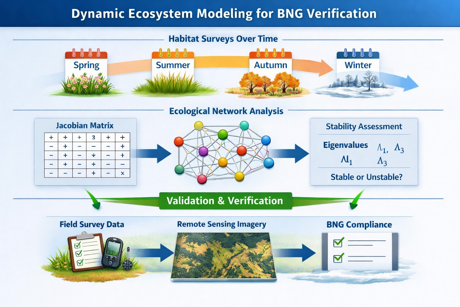
The new generation of surveyor tools utilizes time series analysis to quantify ecosystem stability across multiple ecological levels. The "estar" R package, published in Methods in Ecology and Evolution in 2026, calculates eleven established stability indicators using Jacobian matrices to assess community-level dynamics[2]. This mathematical approach enables surveyors to:
- Measure resilience 🔄 – How quickly ecosystems recover from disturbances
- Quantify variability 📊 – Natural fluctuations in species abundance and habitat quality
- Assess persistence ⏱️ – Long-term stability of biodiversity gains
- Evaluate connectivity 🔗 – Interactions between habitat patches and species populations
For developers navigating biodiversity net gain requirements, this shift means verification processes now demand multi-season surveys and predictive modeling rather than single baseline assessments.
Key Components of Dynamic Modeling Systems
Modern BNG verification platforms integrate several technological components:
| Component | Function | Benefit for Surveyors |
|---|---|---|
| Real-time dashboards | Monitor biodiversity metrics during design phases[1] | Immediate feedback on design decisions |
| Automatic calculations | Compute project boundaries, habitat totals, hedgerows, water courses[1] | Reduces manual calculation errors |
| Polygon-level specifications | Apply BNG parameters to individual habitat units[1] | Granular control over verification |
| GIS export capabilities | Generate shapefiles for collaborative workflows[1] | Seamless integration with planning systems |
| Stability indicators | Calculate 11 standardized ecosystem metrics[2] | Scientifically robust verification |
These tools enable surveyors to provide comprehensive biodiversity assessments that satisfy both regulatory requirements and ecological best practices.
Surveyor Tools and Software Solutions for BNG Verification in 2026
Real-Time Monitoring and Sustainability Dashboards
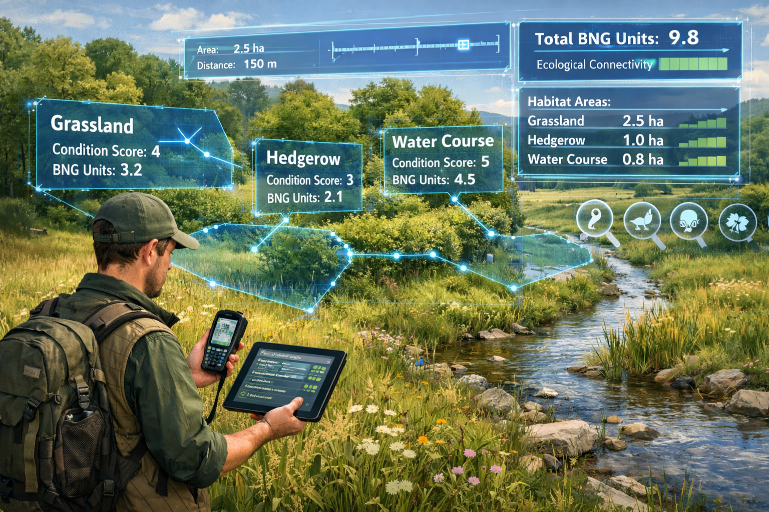
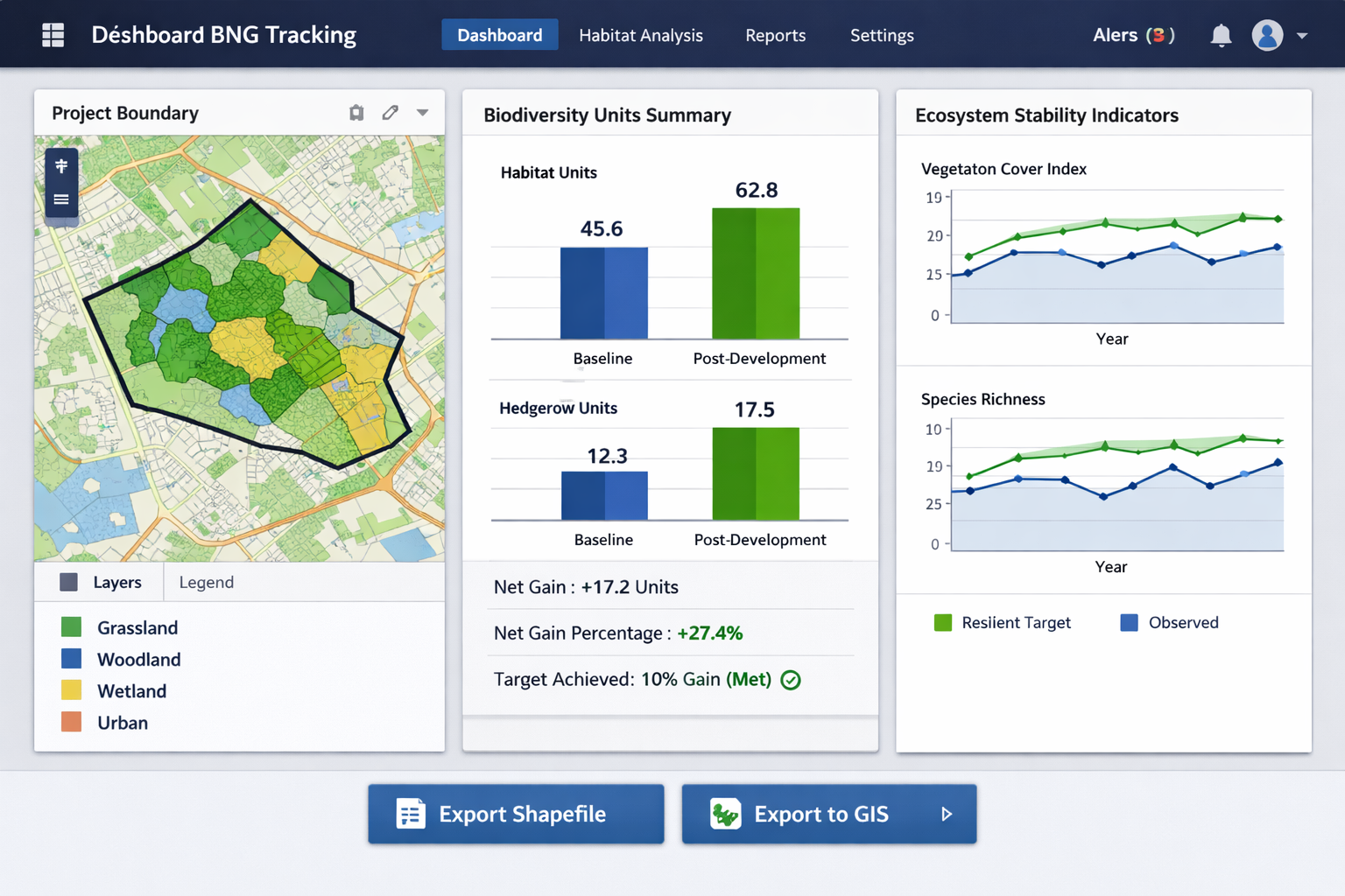
The 2026 generation of BNG tracking software represents a significant advancement in surveyor capabilities. Vector's Sustainability Dashboard exemplifies this evolution, offering real-time monitoring throughout project design phases[1]. The platform automatically calculates:
- Project boundary areas with GPS-integrated mapping
- Habitat totals across all polygon classifications
- Hedgerow lengths and connectivity metrics
- Water course measurements and riparian zone assessments
This automation dramatically reduces the time surveyors spend on manual calculations while improving accuracy. The system supports BNG specifications for individual polygons, allowing surveyors to assign condition scores, distinctiveness ratings, and strategic significance values at granular levels[1].
For developers seeking to achieve 10% biodiversity net gain, these dashboards provide immediate visibility into whether design modifications meet regulatory thresholds before submitting planning applications.
Integration with GIS and Collaborative Workflows
Ecosystem Dynamics Modeling for BNG Verification: Surveyor Tools from Frontiers Research Topics in 2026 emphasizes interoperability between field survey tools and planning systems. Modern platforms export results to both text and shapefile formats, enabling seamless collaboration across multidisciplinary teams[1].
This integration capability addresses a common pain point in BNG compliance: the disconnect between ecological surveys, landscape architects, and planning authorities. When surveyors can export verified habitat polygons directly into GIS systems used by design teams, the entire workflow accelerates.
Key integration features include:
✅ Shapefile exports compatible with ArcGIS, QGIS, and AutoCAD
✅ API connections to local planning authority databases
✅ Cloud synchronization for multi-surveyor field teams
✅ Version control tracking changes across design iterations
✅ Automated reporting generating compliant BNG assessment documents
For planners managing multiple projects, understanding how biodiversity net gain impacts planning decisions becomes easier when verification data flows seamlessly into existing systems.
Applying Frontiers Research Topics to Field Verification Protocols
Temporal Stability Indicators in Practice
The integration of ecosystem stability research into surveyor protocols represents a major advancement in BNG verification rigor. The eleven stability indicators now standardized through the "estar" package provide surveyors with quantitative metrics for temporal dynamics[2]:
Population-Level Indicators:
- Coefficient of variation (CV)
- Return rate to equilibrium
- Temporal stability
Community-Level Indicators:
- Synchrony across species
- Portfolio effects
- Compensatory dynamics
- Species stability
- Community stability
Ecosystem-Level Indicators:
- Aggregate ecosystem properties
- Functional redundancy
- Resistance and resilience metrics
For surveyors conducting field assessments, these indicators translate into specific data collection protocols. Rather than a single spring survey, verification now requires:
- Multi-season sampling 🌸🍂 – Capturing seasonal variations in species composition
- Repeated measurements 📏 – Establishing baseline variability before development
- Long-term monitoring 📅 – Verifying persistence of biodiversity gains post-development
- Disturbance response ⚡ – Assessing resilience to environmental stressors
This approach aligns with government BNG consultation recommendations emphasizing robust verification mechanisms.
Field Validation Steps for Dynamic Models
Implementing Ecosystem Dynamics Modeling for BNG Verification: Surveyor Tools from Frontiers Research Topics in 2026 requires surveyors to adopt new field protocols that support temporal analysis:
Step 1: Baseline Characterization 🔍
- Conduct minimum three seasonal surveys across one year
- Record species abundance, habitat condition, and environmental variables
- Establish natural variability ranges for stability calculations
- Document disturbance history and succession stage
Step 2: Data Collection for Stability Analysis 📊
- Use standardized sampling methods (quadrats, transects, point counts)
- Maintain consistent spatial locations for temporal comparisons
- Collect ancillary environmental data (soil moisture, temperature, precipitation)
- Photograph reference points for visual change documentation
Step 3: Model Parameterization 🔢
- Input time series data into stability calculation software
- Generate Jacobian matrices for community-level dynamics[2]
- Calculate all eleven stability indicators
- Compare results against regional reference ecosystems
Step 4: Verification Against BNG Targets ✔️
- Map stability indicators to BNG unit calculations
- Assess whether biodiversity gains meet persistence criteria
- Identify high-risk areas requiring enhanced management
- Generate verification reports for planning authorities
For landowners considering selling biodiversity units, demonstrating ecosystem stability through these protocols increases market value and buyer confidence.
Remote Sensing Integration
Advanced BNG verification increasingly incorporates remote sensing data to complement field surveys. Satellite imagery, drone surveys, and LiDAR provide temporal data at scales impossible through ground surveys alone. NASA's biodiversity mapping projects demonstrate how remote sensing captures landscape-level dynamics[3].
Surveyors can now:
- Track vegetation changes across project sites between field visits
- Validate habitat extent using multispectral imagery
- Monitor hydrological patterns affecting wetland habitats
- Assess landscape connectivity through spatial analysis
This integration reduces the frequency of expensive field visits while maintaining verification rigor, particularly for off-site BNG delivery where monitoring multiple locations becomes logistically challenging.
Practical Implementation for Developers and Surveyors
Selecting Appropriate Tools for Project Scale
Not all BNG verification projects require the full suite of dynamic modeling capabilities. Surveyors must match tool complexity to project characteristics:
Small Development Projects 🏘️
- May utilize simplified dashboards with basic habitat calculations
- Focus on key stability indicators (CV, return rate)
- Limited temporal sampling (two seasons minimum)
- Small development BNG requirements often allow streamlined protocols
Medium-Scale Developments 🏗️
- Full dashboard implementation with polygon-level specifications
- Comprehensive stability analysis across multiple habitat types
- Three-season baseline plus post-development monitoring
- GIS integration for design iteration support
Large Infrastructure Projects 🛣️
- Enterprise-level platforms with multi-site coordination
- All eleven stability indicators across ecosystem levels
- Multi-year baseline establishment
- Remote sensing integration for landscape-scale assessment
Understanding what's included in a BNG assessment helps developers budget appropriately for verification tools matching their project scale.
Cost-Benefit Analysis of Dynamic Verification
While Ecosystem Dynamics Modeling for BNG Verification: Surveyor Tools from Frontiers Research Topics in 2026 requires greater upfront investment than traditional static assessments, the benefits often outweigh costs:
Benefits:
- ✅ Reduced risk of planning rejection due to inadequate verification
- ✅ Higher confidence in long-term biodiversity gain persistence
- ✅ Faster design iterations through real-time feedback
- ✅ Defensible documentation for regulatory compliance
- ✅ Potential reduction in statutory credit purchases through optimized design
Costs:
- 💰 Software licensing fees (typically £2,000-£15,000 annually depending on scale)
- 💰 Additional field survey visits (2-3 extra seasonal surveys)
- 💰 Specialist training for surveyors on stability analysis
- 💰 Data storage and processing infrastructure
For most developers, the ability to optimize designs before finalizing plans delivers significant savings. Understanding the cost of biodiversity units and statutory credits reveals that avoiding even small credit purchases through better verification often justifies the investment in advanced tools.
Training and Competency Requirements
Effective use of dynamic modeling tools requires surveyors to develop new competencies beyond traditional habitat assessment skills:
Core Competencies:
- Statistical literacy – Understanding time series analysis and stability metrics
- Software proficiency – Operating dashboard platforms and R packages like "estar"
- GIS capabilities – Managing spatial data and shapefile workflows
- Ecological theory – Interpreting community dynamics and ecosystem processes
- Regulatory knowledge – Applying tools within BNG legislative frameworks
Professional development pathways include:
- Workshops on ecosystem stability theory and calculation methods
- Software-specific training from platform providers
- Field courses on temporal sampling protocols
- Certification programs in BNG verification
Organizations like Biodiversity Surveyors increasingly offer specialized training programs addressing these emerging competency requirements.
Regulatory Compliance and Future Directions
Meeting Current BNG Statutory Requirements
As of 2026, the UK's mandatory biodiversity net gain requirements have matured beyond initial implementation. While statutory instruments don't explicitly mandate dynamic modeling, planning authorities increasingly expect verification methodologies that demonstrate temporal persistence of biodiversity gains.
Ecosystem Dynamics Modeling for BNG Verification: Surveyor Tools from Frontiers Research Topics in 2026 aligns with regulatory expectations by:
- Providing scientifically defensible evidence of ecosystem stability
- Documenting baseline variability that informs realistic gain predictions
- Supporting adaptive management through ongoing monitoring capabilities
- Generating audit trails for compliance verification
Developers should consult guidance on BNG planning requirements to understand how dynamic verification fits within broader compliance strategies.
Emerging Standards and Best Practices
Professional bodies and government agencies are developing standardized protocols for dynamic BNG verification. Key trends include:
📋 Standardized stability thresholds – Defining minimum acceptable values for resilience metrics
📋 Temporal sampling guidelines – Specifying seasonal survey requirements by habitat type
📋 Software certification schemes – Ensuring calculation accuracy across platforms
📋 Auditing frameworks – Independent verification of dynamic modeling outputs
These emerging standards will likely become formalized in future BNG guidance updates, making early adoption of dynamic modeling tools a strategic advantage for surveying firms.
Integration with Broader Environmental Goals
Dynamic ecosystem modeling for BNG verification connects to wider environmental policy objectives beyond planning compliance:
Climate Resilience 🌡️
Stability indicators help identify habitats most resilient to climate change, informing strategic site selection for off-site BNG delivery.
Nature Recovery Networks 🌿
Connectivity analysis within dynamic models supports landscape-scale conservation planning aligned with Local Nature Recovery Strategies.
Sustainable Land Management 🚜
Temporal monitoring protocols complement agricultural schemes like the Sustainable Farming Incentive, creating synergies between farming and biodiversity objectives.
Net Zero Alignment 🌍
Ecosystem stability metrics correlate with carbon sequestration potential, enabling integrated approaches to biodiversity and climate goals.
Conclusion
Ecosystem Dynamics Modeling for BNG Verification: Surveyor Tools from Frontiers Research Topics in 2026 represents a fundamental evolution in how the development sector approaches biodiversity compliance. By shifting from static snapshots to dynamic temporal analysis, these tools provide more accurate predictions of biodiversity gain persistence while reducing regulatory risk.
The integration of standardized stability indicators, real-time monitoring dashboards, and GIS-compatible workflows empowers surveyors to deliver verification services that meet both current statutory requirements and emerging best practice standards. For developers, this translates to greater confidence in planning approvals, optimized design decisions, and defensible documentation of environmental commitments.
Actionable Next Steps
For Developers:
- Evaluate current BNG verification approaches against dynamic modeling capabilities
- Consult with surveyors experienced in temporal stability analysis
- Budget for multi-season baseline surveys in project timelines
- Explore comprehensive BNG guidance for developers
For Surveyors:
- Invest in training on ecosystem stability theory and calculation methods
- Trial dashboard platforms offering real-time BNG monitoring
- Develop standard operating procedures for temporal sampling protocols
- Build partnerships with GIS specialists for workflow integration
For Landowners:
- Understand how dynamic verification increases biodiversity unit value
- Establish baseline monitoring on potential BNG sites
- Review landowner guidance on habitat creation and management
For Planning Authorities:
- Develop policies encouraging dynamic verification methodologies
- Provide clear guidance on acceptable stability thresholds
- Invest in training for planning officers on temporal BNG assessment
The tools and methodologies emerging from Frontiers research topics in 2026 position the biodiversity sector to deliver net gain commitments that genuinely enhance ecosystem resilience for decades to come. As regulatory frameworks continue evolving, early adoption of dynamic modeling approaches will distinguish leading practitioners and deliver superior environmental outcomes.
For personalized guidance on implementing these advanced verification tools in your projects, contact biodiversity specialists experienced in the latest methodologies.
References
[1] Watch – https://www.youtube.com/watch?v=lucVHr-5MBE
[2] 2026 03 Software Biodiversity Enables Comprehensive Quantification – https://phys.org/news/2026-03-software-biodiversity-enables-comprehensive-quantification.html
[3] Projmap – https://cce.nasa.gov/biodiversity/_biomap/projmap.html
