

England's mandatory Biodiversity Net Gain regime has now been in force long enough to expose a stubborn problem: the static, snapshot-in-time nature of traditional ecological surveys struggles to keep pace with dynamic, living habitats. Digital twins for biodiversity net gain modeling are emerging as a direct response to that gap, offering development teams a way to simulate, test, and verify habitat outcomes before a single spade breaks ground. This article explains how these computer-generated ecosystem replicas work, why they matter for survey accuracy in 2026 projects, and what surveyors, planners, and developers can do right now to take advantage of them.
Key Takeaways
- Digital twins create live, updateable virtual replicas of habitats that improve the accuracy of biodiversity net gain calculations compared to one-off field surveys.
- Frameworks such as FAIR Digital Twins and prototype platforms like BioDT are establishing the technical standards that 2026 projects can begin to adopt.
- Real-world applications in wetlands, rivers, and urban green infrastructure show measurable gains in prediction confidence and monitoring efficiency.
- Integration with remote sensing, IoT sensors, and citizen science data allows continuous model refinement throughout a project's lifetime.
- Governance, data standardization, and formal BNG regulatory integration remain the key challenges to widespread adoption in the near term.
What Are Ecological Digital Twins and Why Do They Matter for BNG?
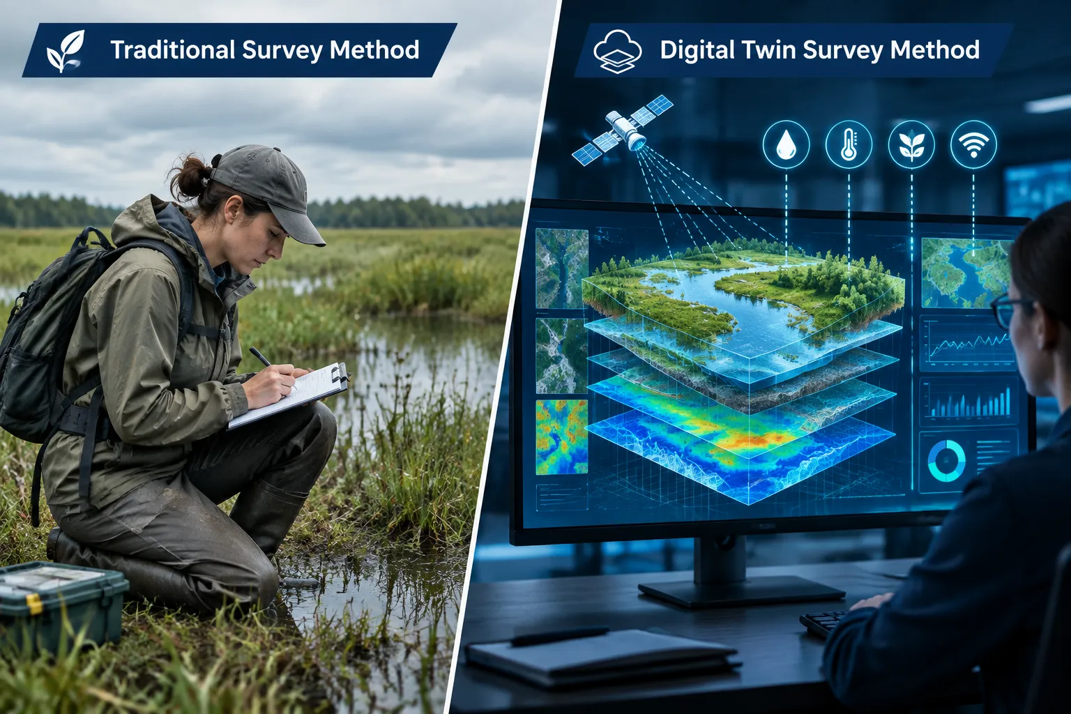
A digital twin is a dynamic, data-driven virtual replica of a physical system that updates continuously as new information arrives. In ecology, these are formally defined as multi-scale ecosystem representations built for prediction and adaptive management [2]. Unlike a conventional habitat survey, which captures a single moment, an ecological digital twin (EcoDT) can simulate how a meadow, hedgerow, or wetland will respond to changes in land use, hydrology, or climate over months and years.
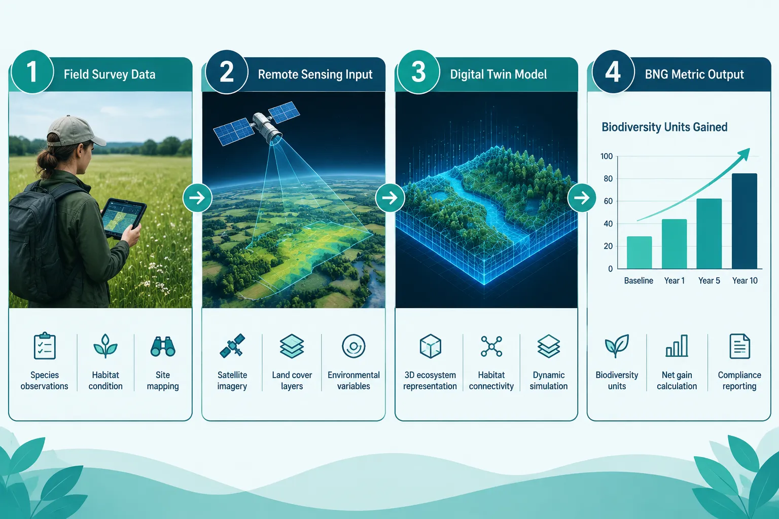
For teams working under England's BNG framework, this distinction is significant. The statutory metric requires developers to demonstrate a measurable uplift in biodiversity units, and that calculation depends heavily on the baseline habitat assessment. If the baseline is inaccurate or fails to account for seasonal variation, the entire BNG calculation is compromised. Understanding what is in a biodiversity net gain assessment makes clear just how many variables feed into that baseline, condition scores, distinctiveness ratings, connectivity, and strategic significance all play a role.
Digital twins address this by replacing or supplementing point-in-time surveys with continuously updated models. Sensor arrays, satellite imagery, and even citizen science records feed data into the twin, keeping it current [8]. The result is a baseline that reflects the habitat as it actually exists across seasons, not just on the day a surveyor visited.
Key components of an ecological digital twin include:
- Remote sensing layers (satellite and drone imagery)
- In-situ IoT sensors measuring soil moisture, temperature, and species presence
- Species distribution models linked to real-time environmental data
- Hydrological and climate scenario modules
- A BNG metric calculation engine that updates as conditions change
How Digital Twins for Biodiversity Net Gain Modeling Enhance Survey Accuracy in 2026 Projects
The accuracy problem in conventional BNG surveys is well documented. A surveyor visiting a site in late summer may miss early-spring indicator species; a single visit cannot capture the full mosaic of a complex habitat. These gaps translate directly into either under- or over-stated biodiversity unit values, creating financial and legal risk for developers.
Digital twins for biodiversity net gain modeling address this in several concrete ways.
Continuous Baseline Refinement
Rather than locking in a baseline at the point of survey, a digital twin allows the baseline to be built up over time from multiple data sources. The BioDT initiative, which prototypes practical biodiversity digital twins for nature-positive assessments, demonstrates how species occurrence records, remote sensing change-detection, and modeled habitat suitability can be fused into a single, coherent baseline layer [5]. This multi-source approach reduces the risk of missing rare or cryptic species that a single field visit would overlook.
Scenario Testing Before Commitment
One of the most powerful features of a digital twin is the ability to run "what-if" scenarios. A developer can model the effect of different mitigation strategies, retaining a hedgerow versus replacing it with a wildflower margin, for example, and compare predicted biodiversity unit outcomes before finalizing a design. This is directly relevant to decisions about biodiversity net gain off-site or on-site delivery, where the relative merits of different delivery options need to be weighed against habitat quality predictions.
The digital ecohydraulic twin concept (demonstrated through the RETwin project) shows how this works in practice for river and wetland habitats. By coupling hydrological models with habitat suitability algorithms, RETwin dramatically reduced the time needed to evaluate habitat outcomes for different flow management scenarios [2]. The same logic applies to any habitat type where hydrology, soil conditions, or connectivity are key drivers of biodiversity value.
Reducing Uncertainty in Long-Term Monitoring
BNG obligations extend for a minimum of 30 years under the current English regime. Monitoring those obligations with periodic manual surveys is expensive and introduces cumulative uncertainty. A digital twin provides a persistent, auditable record of habitat condition that can be interrogated at any point, reducing the cost and improving the consistency of long-term monitoring.
"The most significant contribution of ecological digital twins to BNG is not the initial survey, it is the ability to maintain a credible, evidence-based record of habitat condition across the full 30-year obligation period."
Real-World Applications: Case Studies Relevant to BNG Surveyors
Wetland and Riparian Habitats
Wetlands are among the most dynamic and ecologically sensitive habitat types covered by the BNG metric. Digital twins of wetland systems have demonstrated near-real-time monitoring of water levels, vegetation cover, and species activity, providing a level of temporal resolution that manual surveys cannot match [8]. For surveyors working on developments adjacent to rivers, floodplains, or coastal margins, this capability is directly applicable to both baseline assessment and post-completion monitoring.
The European Digital Twin Ocean (EDITO) platform is already operational and monitoring marine biodiversity and habitats in near-real time [5]. While EDITO's primary focus is marine, its technical architecture, integrating satellite data, in-situ sensors, and species models, is directly transferable to terrestrial BNG applications.
AI-Enabled Habitat Monitoring for Wildlife Reintroductions
AI-powered remote sensing tools are being trialed for habitat assessment in the context of wildlife reintroductions, using drone imagery, acoustic sensors, and machine learning classifiers to detect species presence and habitat condition at scale [9]. These tools are not yet standard practice in BNG surveys, but they represent the near-term direction of travel. Surveyors who build familiarity with these methods now will be better positioned as the technology matures.
Urban Green Infrastructure
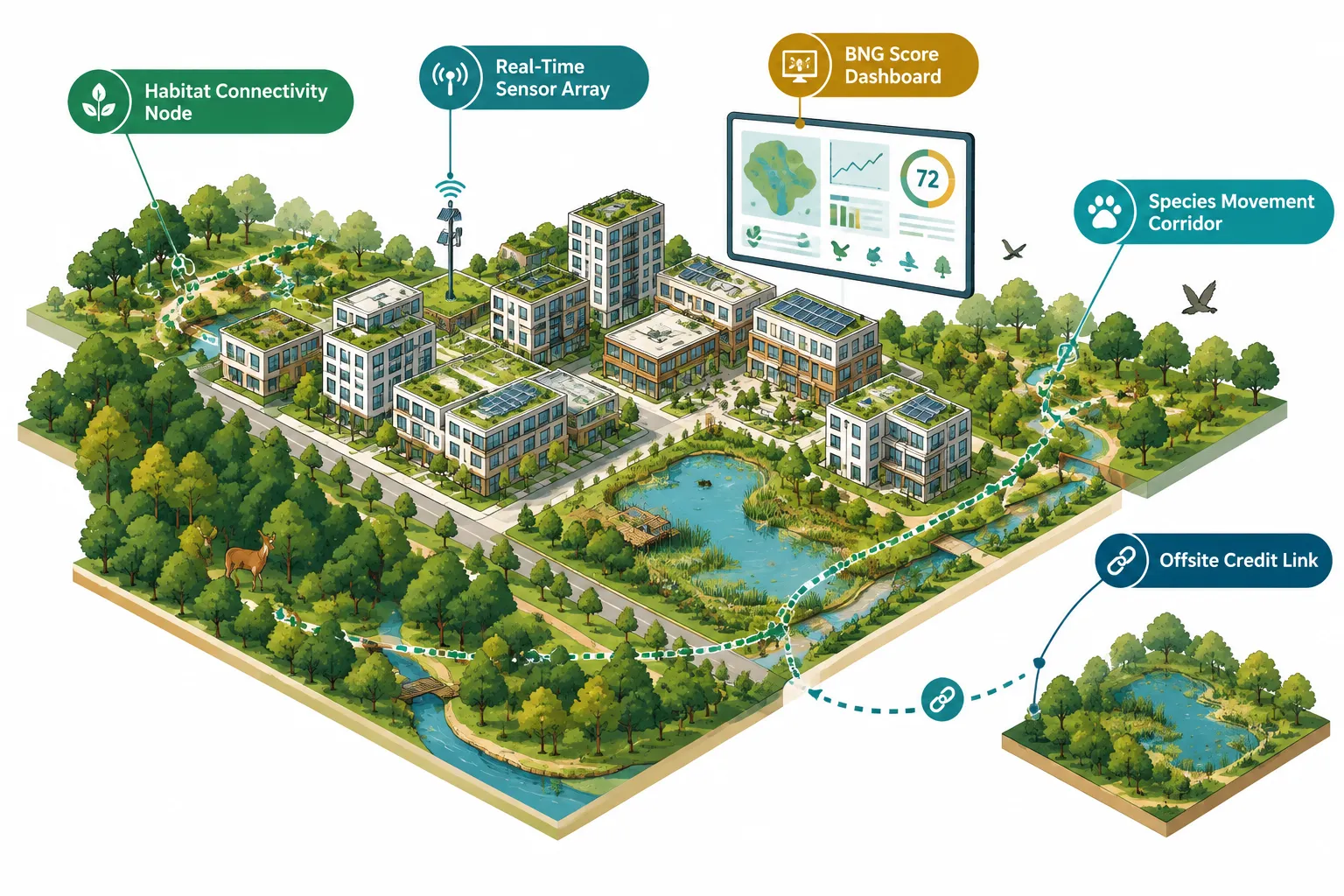
Smart infrastructure projects are beginning to integrate biodiversity metrics into urban digital environments, creating city-scale twins that track green corridor connectivity, urban tree canopy, and species movement [7]. For planners and architects working on urban development, this opens the possibility of testing BNG outcomes at the masterplan stage, long before detailed design. Architects looking to understand how these tools fit into the design process can explore how architects can solve biodiversity net gain as a starting point.
FAIR Digital Twins and the Governance of BNG Evidence
The FAIR Digital Twins (FDTs) framework, where FAIR stands for Findable, Accessible, Interoperable, and Reusable, provides the most rigorous conceptual architecture for biodiversity digital twins in 2026 [4]. FDTs are designed to ensure that the data underpinning a digital twin can be independently verified, shared across platforms, and reused for multiple regulatory purposes.
This matters enormously for BNG. The statutory metric is a legal instrument, and the evidence base supporting a BNG calculation must be defensible in planning appeals and legal challenges. A digital twin built on FAIR principles creates an auditable data trail from raw sensor readings through to the final biodiversity unit score. This is a significant improvement over the current situation, where baseline surveys are often documented in PDF reports with limited ability to interrogate the underlying data.
The FAIR framework applied to BNG digital twins requires:
| FAIR Principle | Application to BNG Digital Twin |
|---|---|
| Findable | Habitat data assigned persistent identifiers, searchable in national registers |
| Accessible | Data retrievable via open APIs by planning authorities and third-party auditors |
| Interoperable | Standardized habitat classification aligned with the UK Habitat Classification |
| Reusable | Data licensed and documented so it can support future BNG reviews and monitoring |
England's planning system is beginning to explore environmental digital twins for habitat tracking and planning support [1], and the FAIR framework is likely to underpin any formal integration of digital twin evidence into the BNG regulatory process.
The governance dimension is equally important. Digital twins and the "digital logics of biodiversity" raise genuine questions about who controls the model, who validates its outputs, and how uncertainty is communicated to decision-makers [10]. For BNG purposes, these are not abstract concerns. If a developer's digital twin predicts a 12% biodiversity net gain but an independent ecologist's field survey suggests only 8%, the planning authority needs a clear framework for adjudicating between them.
Planners seeking a grounding in these issues will find the top 12 questions by planners about biodiversity net gain a useful reference, particularly on the question of evidence standards.
Integrating Digital Twin Outputs into BNG Assessments: A Practical Framework
For development teams ready to incorporate digital twin methods into their BNG workflow, a structured approach is essential. The following framework reflects current best practice and is designed to be compatible with the statutory metric process.
Step 1: Pre-Application Data Gathering
Commission remote sensing analysis and, where feasible, deploy temporary IoT sensors at least one full growing season before the planning application. This builds a richer baseline than a single survey visit. For guidance on what the assessment process requires, see what is in a biodiversity net gain assessment.
Step 2: Digital Twin Model Build
Use the gathered data to construct or commission an ecological digital twin calibrated to the site's specific habitat types, hydrology, and species assemblage. Ensure the model is built on FAIR principles from the outset.
Step 3: Scenario Analysis and Design Iteration
Run mitigation and enhancement scenarios through the twin to optimize the BNG outcome before design is fixed. This is where the greatest value is realized, changing a design on a computer model costs nothing; changing it on site is expensive.
Step 4: Baseline Verification with Field Surveys
Use targeted field surveys to verify the digital twin's key predictions. This is not about replacing field survey entirely, it is about making field survey more efficient and targeted. For complex sites, understanding how to conduct a biodiversity impact assessment remains essential.
Step 5: Ongoing Monitoring Integration
Connect the digital twin to the long-term monitoring plan required under the BNG legal agreement. Automated data feeds from sensors and periodic remote sensing updates keep the twin current throughout the 30-year obligation.
For developers who want to understand the full planning context before commissioning this level of technical work, reviewing the 8 biodiversity net gain points on planning your project provides a solid foundation.
Challenges and Expectations for 2026 and Beyond
Digital twins for biodiversity net gain modeling are not yet a standard tool in the UK planning system. Several challenges must be acknowledged honestly.
Standardization is incomplete. There is currently no agreed national standard for how a BNG digital twin should be built, validated, or presented to a planning authority. The FAIR framework provides principles, but detailed technical specifications are still being developed [4].
Uncertainty communication is underdeveloped. All models carry uncertainty, and ecological models carry more than most. Planning authorities and developers need clear protocols for how uncertainty ranges in digital twin outputs should be disclosed and interpreted in BNG calculations [2].
Cost and accessibility. Building a full ecological digital twin is currently expensive and technically demanding. Smaller developers working on sites subject to the BNG for small development projects regime may find the investment disproportionate unless costs fall significantly.
Regulatory integration is still emerging. England's planning system is exploring environmental digital twins [1], and the European Commission has spotlighted digital twin projects advancing the green transition [7], but formal integration of digital twin evidence into BNG decision-making is still a near-future expectation rather than a current requirement.
Expected developments by 2030:
- National habitat digital twin standards aligned with the UK Habitat Classification
- Planning authority portals capable of receiving and auditing digital twin data submissions
- Cost reduction through shared infrastructure and open-source modeling platforms
- Formal guidance from Natural England on the use of digital twin evidence in BNG assessments
Conclusion
Digital twins for biodiversity net gain modeling represent one of the most significant methodological advances available to ecological surveyors and development teams in 2026. By replacing static, point-in-time surveys with continuously updated virtual ecosystem models, they improve the accuracy of baseline assessments, enable rigorous scenario testing, and provide a defensible, long-term monitoring record.
Actionable next steps for practitioners:
- Commission remote sensing baseline analysis for any site where BNG is likely to be a significant planning consideration, ideally one full season before application.
- Engage with FAIR Digital Twin principles early in the project to ensure data is structured for regulatory defensibility from the outset.
- Use digital twin scenario outputs to inform design decisions on habitat creation and enhancement before design is fixed, particularly when weighing on-site versus off-site delivery options.
- Collaborate with planning authorities to establish agreed evidence standards for digital twin outputs, rather than waiting for national guidance.
- Stay current with BioDT and national environmental digital twin developments, as formal regulatory integration is expected within the next planning policy cycle.
The technology is advancing rapidly. Teams that build capability now will be better placed to meet both the letter and the spirit of BNG obligations as the regulatory framework matures.
References
[1] England Values Nature Development – esri.com
[2] S44185 025 00116 3 – nature.com
[4] repository.naturalis.nl – repository.naturalis.nl
[5] Biodiversity Digital Twins And Destination Earth Ecosystem – biodt.eu
[7] Spotlight Digital Twins Projects Using Virtual Replicas Advance Europes Green And Digital Transition 2026 06 04 En – hadea.ec.europa.eu
[8] Environmental Digital Twins – air.iuav.it
[9] How Ai Powered Remote Sensing Is Transforming Wildlife Reintroductions – medium.com
[10] Content – api.repository.cam.ac.uk