

}
England's mandatory Biodiversity Net Gain (BNG) requirement, now embedded in the planning system under the Environment Act 2021, has created an unprecedented demand for accurate, repeatable, and defensible habitat surveys. Yet traditional field-only methods, clipboards, paper maps, and manual data entry, struggle to keep pace with the volume, complexity, and monitoring timescales that BNG demands. Digital tools for ecologists, using GIS, remote sensing, and drones to streamline biodiversity net gain surveys, are rapidly closing that gap, turning weeks of desk study and fieldwork into streamlined, evidence-rich workflows that planning authorities and developers can trust.
Key Takeaways
- GIS, remote sensing, and drone technology are transforming how ecologists collect, process, and report BNG baseline data.
- Integrated digital platforms combining field apps, automated metric calculations, and collaborative mapping cut survey time significantly compared to traditional methods.
- AI-powered tools and rapid assessment apps are making the statutory 10% net gain target more achievable for projects of all sizes.
- Accurate digital baselines improve the quality of BNG assessments, reduce rework, and strengthen planning submissions.
- Monitoring obligations over 30-year BNG management periods make long-term digital data infrastructure essential, not optional.
Why Traditional Survey Methods Fall Short for BNG
Biodiversity Net Gain is not a one-off box-ticking exercise. It requires a quantified baseline, a metric calculation, a management and monitoring plan, and evidence of delivery across a 30-year period. Understanding what is in a biodiversity net gain assessment makes it clear why the data burden is substantial.
Traditional survey approaches carry several structural weaknesses when applied to BNG:
- Inconsistency between surveyors, subjective habitat condition scoring varies between individuals, undermining repeatability.
- Data transfer bottlenecks, field notes transcribed into spreadsheets introduce errors and delay metric calculations.
- Limited spatial resolution, hand-drawn maps lack the precision needed for polygon-level UKHab classification across large sites.
- Poor audit trails, paper records are difficult to version-control or share with planning authorities and developers.
- Monitoring gaps, revisiting sites annually for 30 years without a structured digital record system creates compliance risk.
These weaknesses are not minor inconveniences. They directly affect the credibility of a BNG submission and the confidence of local planning authorities in approving it.
The Core Digital Toolkit: GIS, Remote Sensing, and Drones
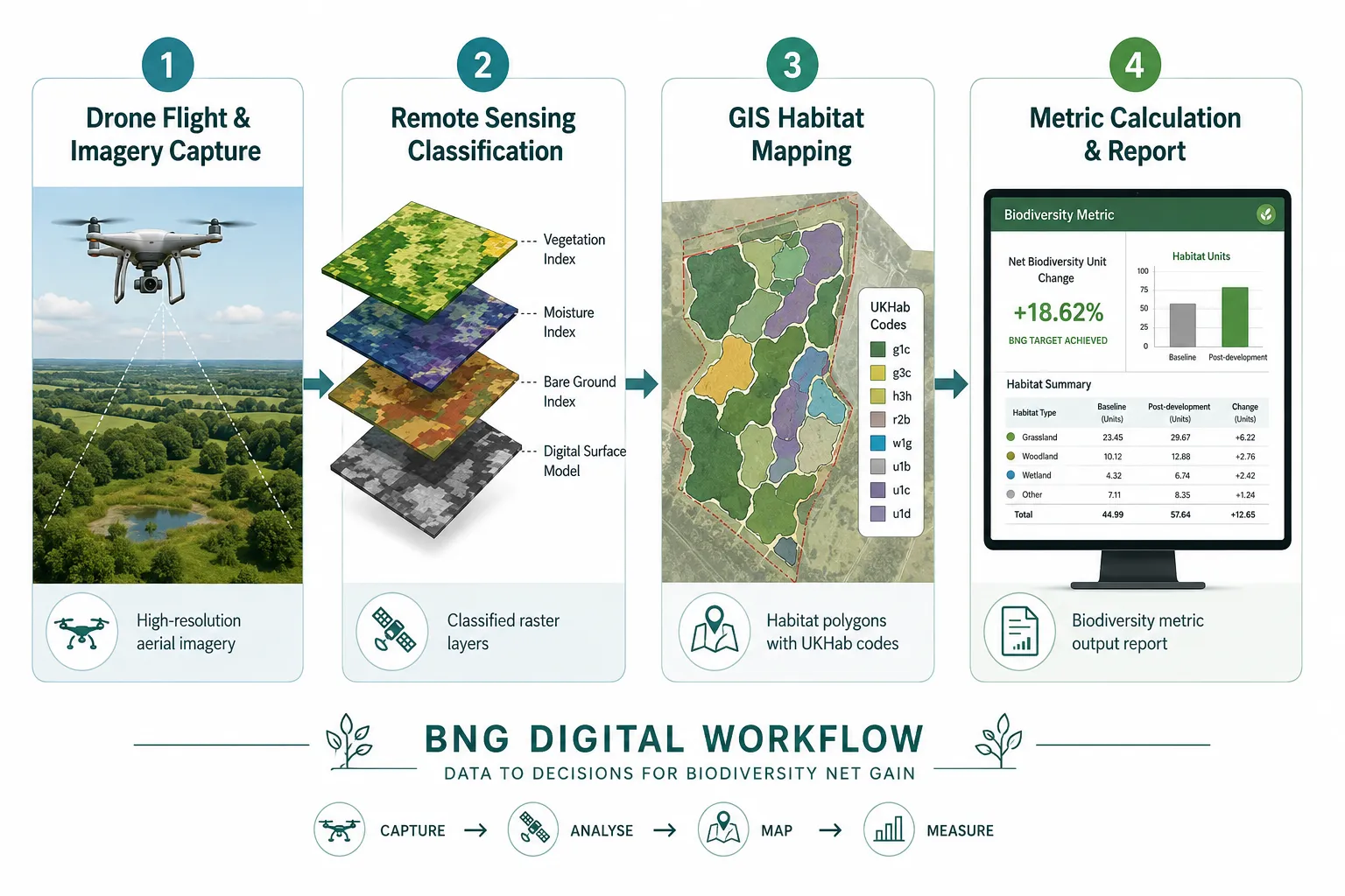
The phrase "digital tools for ecologists: using GIS, remote sensing, and drones to streamline biodiversity net gain surveys" covers a layered set of technologies that work best in combination. Each layer contributes something distinct to the overall workflow.
Geographic Information Systems (GIS)
GIS platforms, including QGIS, ArcGIS, and web-based alternatives, provide the spatial backbone for BNG work. Ecologists use GIS to:
- Digitize habitat polygons against OS base maps or aerial imagery
- Apply UKHab classification codes to each polygon
- Calculate habitat areas with sub-metre accuracy
- Overlay constraints data (flood zones, protected sites, ancient woodland buffers)
- Export data directly into the Statutory Biodiversity Metric tool
Modern GIS workflows also support collaboration. Multiple surveyors can work on the same project layer simultaneously, with version control ensuring that the most recent data is always used in metric calculations.
Remote Sensing and Aerial Imagery
Satellite and aerial imagery have become foundational to BNG baseline work. High-resolution multispectral imagery allows ecologists to distinguish habitat types, detect vegetation stress, and identify land cover change at scales impossible to achieve on foot alone.
County-level BNG baseline mapping projects, guided by bodies such as ALERC, have used remote sensing to create consistent regional datasets that individual site surveys can reference and validate against. This approach reduces duplication of effort and improves the reliability of condition assessments across large geographic areas.
Key remote sensing applications for BNG include:
| Application | Benefit |
|---|---|
| Multispectral vegetation mapping | Distinguishes grassland, scrub, and woodland types |
| Change detection analysis | Identifies habitat loss or gain between survey periods |
| NDVI analysis | Quantifies vegetation health and density |
| LiDAR canopy height models | Supports woodland structure assessment |
| Thermal imaging | Detects wetland features and water table variation |
Drone Surveys
Unmanned aerial vehicles (UAVs) bridge the gap between satellite imagery and ground-level observation. A drone equipped with a high-resolution RGB or multispectral camera can survey a 10-hectare site in under an hour, producing orthomosaic imagery accurate to 2-3 cm per pixel.
For BNG purposes, drones deliver:
- Detailed habitat boundary mapping at a resolution that supports confident UKHab polygon delineation
- Condition assessment evidence, close-range imagery of sward structure, bare ground percentage, and scrub encroachment
- Repeat monitoring data, annual drone flights over the same area provide a consistent, comparable record of habitat change
- Hard-to-access habitat coverage, steep slopes, reedbeds, and large woodland blocks can be surveyed safely without trampling
When drone data is processed in GIS and linked to a digital field survey record, the resulting dataset is far more defensible than a hand-drawn map supported by written notes alone.
Integrated Digital Platforms: From Field to Metric
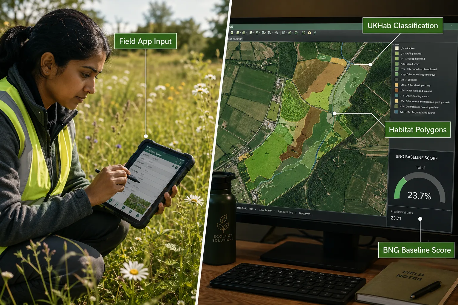
Hardware alone does not solve the BNG data challenge. The real efficiency gains come from integrated software platforms that connect field data collection, GIS processing, and metric calculation in a single workflow.
Several specialist platforms have emerged to serve this need directly.
Coreo is a UKHab and BNG-focused platform that combines a mobile field app, GIS mapping tools, and automated metric calculation. Surveyors collect habitat data in the field using the app, which enforces consistent UKHab classification and condition scoring. That data flows directly into GIS layers and then into the metric, eliminating manual re-entry [6][8]. A documented case study from Nattergal's rewilding project demonstrated how Coreo's digital workflow replaced fragmented spreadsheet-and-email processes with a single auditable system [9].
BNG.ai uses artificial intelligence to accelerate BNG compliance, with the platform claiming survey workflows up to 70% faster than conventional methods [2]. By automating habitat classification from imagery and pre-populating metric inputs, the platform reduces the time ecologists spend on desk-based processing.
The Land App offers GIS-based habitat mapping tools designed specifically for ecologists, supporting UKHab classification, area calculation, and collaboration across project teams [3]. Its browser-based interface makes it accessible without specialist GIS software licences.
Pin Drop provides a field survey and ecological data collection platform that supports multi-taxa recording and shared mapping, making it practical for larger survey teams working across a site simultaneously [5].
Ground Control's GC-Go app targets rapid BNG assessments, allowing ecologists to generate a preliminary metric output quickly, useful for feasibility-stage advice to developers before full survey investment [7].
Dulra offers an AI-powered ecological survey platform that connects field observations to desk-based analysis, supporting the transition from raw data to reportable outputs [4].
Mozaic Earth provides a scientifically validated content platform that feeds species and habitat data into BNG assessments and baseline construction, drawing on verified ecological datasets [10].
"The shift from fragmented paper-and-spreadsheet workflows to integrated digital platforms is not just an efficiency story, it is a data quality story. Consistent classification, automated calculations, and shared audit trails reduce the risk of errors that could undermine a planning submission."
For ecologists advising developers, understanding how to conduct a biodiversity impact assessment becomes significantly more straightforward when the data infrastructure is already digital from the first site visit.
Practical Workflow: Combining Technologies for a BNG Survey
The strongest BNG workflows in 2026 combine all three technology layers in a logical sequence. A typical project might follow this structure:
1. Pre-survey desk study
- Download existing aerial imagery and OS data into GIS
- Run a preliminary habitat classification using remote sensing layers
- Identify areas of potential interest for targeted field survey
- Check constraints data (SSSIs, ancient woodland, flood risk)
2. Drone flight
- Fly the site to capture high-resolution RGB and multispectral orthomosaics
- Process imagery into georeferenced rasters within GIS
- Delineate preliminary habitat polygons from drone imagery
3. Ground-truthing field survey
- Use a digital field app (Coreo, Land App, or similar) to validate and refine polygon boundaries
- Record UKHab condition scores against each polygon using standardised criteria
- Photograph representative areas with geotagged images linked to the GIS record
4. Metric calculation
- Import confirmed polygon data directly into the Statutory Biodiversity Metric
- Review outputs and identify any data gaps requiring additional survey effort
- Generate the biodiversity unit score and document the methodology
5. Reporting and submission
- Export GIS layers as supporting evidence for the biodiversity net gain report
- Archive the full digital dataset for monitoring use over the 30-year management period
This workflow is repeatable, auditable, and scalable. The same GIS project file used for the baseline survey becomes the monitoring template for every subsequent annual check.
Monitoring Over 30 Years: Why Digital Infrastructure Matters
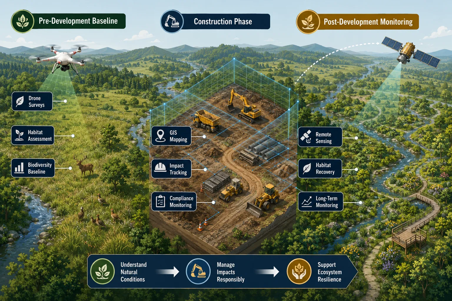
BNG is a long-term legal commitment. Once a habitat management plan is secured through a planning condition or legal agreement, the landowner and developer are bound to deliver measurable biodiversity gains for 30 years. This monitoring obligation is one of the most underappreciated aspects of biodiversity net gain compliance.
Digital tools make long-term monitoring practical in ways that paper-based systems cannot match:
- Consistent baselines, a digital GIS record of the original habitat polygons, condition scores, and species data provides an unambiguous reference point for every future monitoring visit.
- Automated change detection, annual drone flights processed against the original orthomosaic can flag habitat changes automatically, reducing the time ecologists spend on monitoring visits.
- Collaborative platforms, cloud-based systems allow ecologists, landowners, and local planning authorities to access the same dataset, reducing disputes about what was agreed and what has been delivered.
- Reporting efficiency, annual monitoring reports can be generated semi-automatically from updated GIS data, cutting the time required for compliance documentation.
For projects delivering biodiversity net gain off-site, digital monitoring infrastructure is even more critical. Off-site habitat banks serving multiple development projects need robust, independently verifiable data systems to demonstrate that biodiversity units are genuinely being delivered.
Accuracy, Consistency, and Planning Authority Confidence
One of the most significant benefits of digital tools for ecologists using GIS, remote sensing, and drones to streamline biodiversity net gain surveys is the improvement in data consistency. When every surveyor on a project uses the same digital classification system, the same condition scoring criteria, and the same GIS template, the outputs are directly comparable, both within a project and across projects over time.
This consistency matters to planning authorities. Local planning authorities are increasingly familiar with BNG requirements, and many are developing their own capacity to scrutinise metric calculations. A submission backed by georeferenced drone imagery, a digital GIS dataset, and a clear audit trail of how condition scores were determined is far more robust than one supported only by a written report and a hand-drawn map.
For developers, this translates directly into reduced planning risk. Fewer requests for additional information, fewer delays, and greater confidence that the BNG condition will be discharged smoothly. Understanding how to achieve 10% biodiversity net gain is easier when the data underpinning the metric is accurate from the outset.
Key accuracy benefits of digital BNG workflows:
- Polygon boundaries are spatially accurate to sub-metre precision, reducing disputes about habitat areas
- Condition scores are linked to photographic evidence, making them auditable
- Metric calculations are traceable back to raw field data
- Version control prevents outdated data from being used in final submissions
- Multi-surveyor projects maintain consistent classification standards
Challenges and Practical Considerations
Digital tools are not without limitations, and ecologists adopting these workflows need to plan for them.
Equipment costs, quality drone hardware, GIS software licences, and field app subscriptions represent a real investment. However, the time savings on medium and large projects typically offset these costs within a small number of surveys.
Training requirements, effective use of GIS, drone piloting (which requires CAA registration and competency in the UK), and digital field apps requires training. Ecologists new to these tools should budget time for skill development before deploying them on live projects.
Data management, large orthomosaic files and GIS datasets require structured storage and backup systems. A poorly managed data archive can undermine the long-term monitoring value of the original survey investment.
Connectivity in the field, many digital field apps require internet connectivity to sync data. In remote or low-signal areas, offline functionality is essential. Ecologists should verify that their chosen platform supports offline data collection before committing to it.
Regulatory compliance for drones, UAV operations in the UK are governed by CAA regulations. Ecologists must hold appropriate operator and flyer IDs, and flights near protected sites or controlled airspace require additional permissions.
Conclusion
The case for adopting digital tools for ecologists, using GIS, remote sensing, and drones to streamline biodiversity net gain surveys, is now well established. The combination of high-resolution drone imagery, GIS-based habitat mapping, and integrated digital platforms produces BNG baselines and monitoring records that are more accurate, more consistent, and more defensible than traditional methods.
Actionable next steps for ecology practices and developers in 2026:
- Audit your current workflow, identify where manual data entry, paper records, or inconsistent classification are creating risk or inefficiency.
- Pilot a digital field app on a live project, platforms such as Coreo, Land App, or Pin Drop offer trial access and can be evaluated against your existing process.
- Invest in drone capability, either in-house or through a specialist sub-contractor, to improve habitat mapping resolution and establish a repeatable monitoring baseline.
- Build GIS templates for BNG projects that connect directly to the Statutory Biodiversity Metric, reducing re-entry and calculation errors.
- Plan for 30-year monitoring from day one, the digital infrastructure established during the baseline survey should be designed with long-term monitoring in mind, not retrofitted later.
For developers and planners wanting to understand the broader compliance picture, resources on 8 biodiversity net gain points on planning your project provide a useful strategic overview alongside the technical workflow considerations covered here.
Digital tools do not replace ecological expertise, they amplify it. The ecologist's judgment, species knowledge, and professional accountability remain central to every BNG assessment. What digital workflows provide is the data infrastructure to make that expertise count, consistently, at scale, and over the long term.
References
[1] Coreo 1 – biologicalrecording.co.uk
[2] bng.ai – bng.ai
[3] Ecologists – thelandapp.com
[4] Solutions – dulra.io
[5] Ecological Surveys – pindrop.it
[6] Ukhab – coreo.io
[7] Rapid Bng Assessments Gc Go App – ground-control.co.uk
[8] Streamline Your Bng Workflow With Coreo – coreo.io
[9] Streamlining Bng A Digital Solution For Nattergals Rewilding Project – coreo.io
[10] Details – play.google.com