
Imagine watching an ecosystem breathe in real time—tracking every species interaction, predicting biodiversity changes before they happen, and verifying environmental gains with precision previously thought impossible. In 2026, this vision is becoming reality as Digital Twins Beyond Modeling: Real-Time Integration in 2026 Biodiversity Net Gain Surveys transforms how developers, ecologists, and regulators approach biodiversity conservation. No longer confined to static computer simulations, digital twins now integrate live environmental DNA data, artificial intelligence predictions, and on-the-ground sensors to create dynamic, responsive ecosystems models that revolutionize Biodiversity Net Gain (BNG) compliance and monitoring.
The convergence of mandatory 10% biodiversity requirements, advanced graph neural networks, and real-time environmental monitoring marks a watershed moment for conservation technology. As the 2026 Global Horizon Scan identifies digital twins as one of 15 emerging issues shaping biodiversity conservation in the coming decade[2], the practical applications extend far beyond theoretical modeling into hands-on survey calibration and predictive BNG assessment.
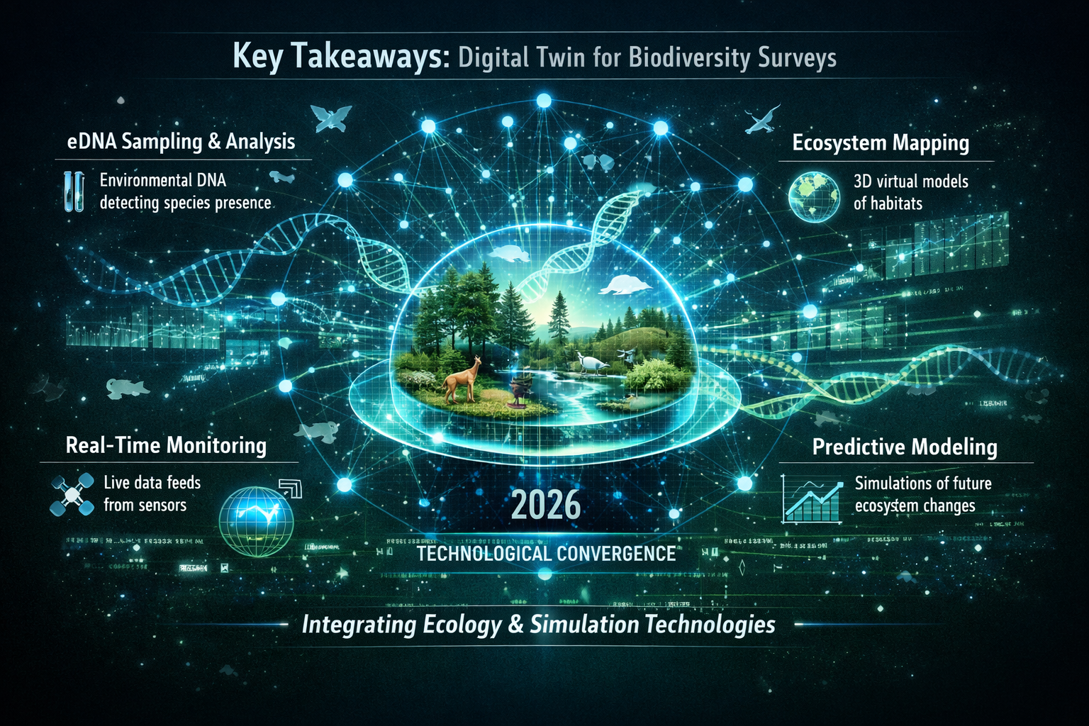
Key Takeaways
🔹 Real-time digital twins combine environmental DNA (eDNA) analysis, graph neural networks, and live sensor data to create dynamic ecosystem simulations that predict biodiversity changes under different scenarios[1][2]
🔹 Mandatory BNG compliance in England requires developers to demonstrate 10% biodiversity increase, driving demand for accurate, verifiable monitoring technologies beyond traditional survey methods[5]
🔹 Multi-scale integration connects spatiotemporal eDNA data from sediment cores with environmental monitoring, enabling taxonomic tracking across space and time for holistic ecosystem assessment[1]
🔹 Accessibility challenges remain central to equitable deployment, as digital twin technologies must work across diverse users including communities with limited digital infrastructure[2]
🔹 Collaborative ecosystems involving water utilities, environmental agencies, and research institutions are building operational infrastructure to translate research models into practical BNG verification tools[1]
From Static Models to Living Ecosystems: The Digital Twin Evolution
Understanding Digital Twins in Biodiversity Context
Traditional biodiversity modeling has long relied on static snapshots—periodic surveys, habitat assessments, and predictive models based on historical data. Digital twins represent a fundamental shift toward continuous, adaptive simulation. These computer-generated replicas of real-world ecosystems integrate multiple data streams simultaneously, creating a "living mirror" that updates as conditions change[2].
The distinction matters enormously for Biodiversity Net Gain assessments. While conventional surveys might capture biodiversity at a single point in time, digital twins track:
- Temporal dynamics: How species populations fluctuate seasonally and annually
- Spatial relationships: Connectivity between habitat patches and migration corridors
- Environmental interactions: Responses to pollution, climate variation, and land use changes
- Predictive scenarios: Likely outcomes under different development or management strategies
This evolution from modeling to integration enables what the European Space Agency calls "interoperability standards"—the ability for different digital twin systems to communicate and share data across projects and jurisdictions[3][7].
The Technology Stack Powering Real-Time Integration
Digital Twins Beyond Modeling: Real-Time Integration in 2026 Biodiversity Net Gain Surveys relies on several converging technologies:
| Technology Component | Function | BNG Application |
|---|---|---|
| Environmental DNA (eDNA) | Species detection from water/soil samples | Rapid baseline assessment and ongoing monitoring |
| Graph Neural Networks (GNNs) | Predict ecosystem interactions and changes | Forecasting biodiversity outcomes under development scenarios |
| Geographic Information Systems (GIS) | Spatial mapping and habitat documentation | Measuring BNG units and tracking habitat area |
| TinyML Devices | Low-power, offline biodiversity detection | Remote site monitoring without internet connectivity |
| Cloud Analytics Platforms | Data integration and dashboard visualization | Real-time compliance reporting for regulators |
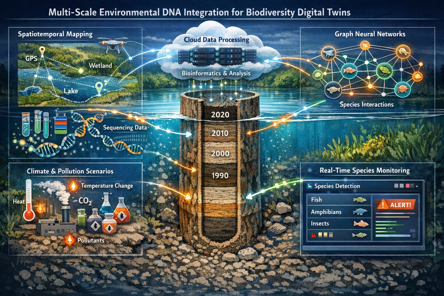
A groundbreaking 2026 doctoral research project at the University of Birmingham exemplifies this integration, developing temporal graph neural networks (TGNs) and spatiotemporal graph neural networks (STGNNs) to monitor and predict biodiversity loss under different climate and pollution scenarios[1]. The project integrates eDNA data from freshwater lake sediment cores across England with environmental monitoring data, creating a holistic digital twin capable of tracking taxonomic changes across multiple scales.
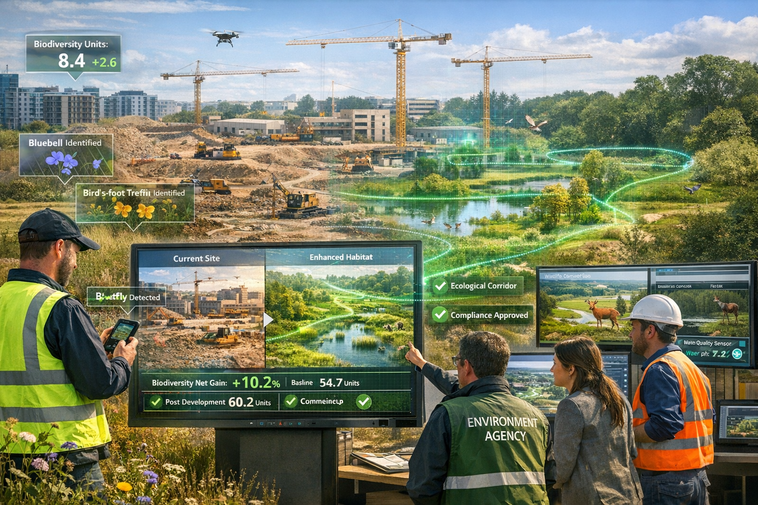
Why Real-Time Matters for BNG Compliance
England's mandatory requirement that developers create 10 percent more biodiversity than existed before development creates enormous verification challenges[5]. Traditional survey methods involve:
- Seasonal delays: Waiting for appropriate survey windows for different species
- Snapshot limitations: Capturing only a moment in ecosystem dynamics
- Verification gaps: Difficulty proving long-term habitat establishment
- Resource intensity: High costs for repeated manual surveys
Real-time digital twin integration addresses these challenges by providing continuous monitoring that validates biodiversity trajectories rather than isolated measurements. As one partnership piloting eDNA for BNG measurement on railway sites demonstrates, these technologies can deliver "faster, more accurate" assessment than conventional approaches[6].
Environmental DNA: The Foundation of Real-Time Biodiversity Detection
How eDNA Transforms Survey Speed and Accuracy
Environmental DNA represents genetic material organisms leave behind in soil, water, and air. A single water sample from a pond can reveal the presence of dozens of species—from fish and amphibians to invertebrates and microorganisms—without direct observation or capture.
For Digital Twins Beyond Modeling: Real-Time Integration in 2026 Biodiversity Net Gain Surveys, eDNA provides several critical advantages:
✅ Comprehensive detection: Identifies rare, nocturnal, or elusive species missed by visual surveys
✅ Temporal resolution: Enables frequent sampling to track population changes
✅ Spatial coverage: Allows systematic sampling across large development sites
✅ Cost efficiency: Reduces field time while increasing data volume
✅ Quantitative metrics: Provides abundance estimates through DNA concentration analysis
The 2026 Birmingham research project dedicates Year 1 specifically to bioinformatics analysis of high-throughput eDNA sequencing data from existing freshwater ecosystems[1]. This foundational work establishes the baseline datasets that feed into predictive models and real-time monitoring systems.
Multi-Scale Integration: From Sediment Cores to Live Monitoring
One of the most innovative aspects of current digital twin development involves spatiotemporal eDNA integration. Sediment cores from lake bottoms contain layered environmental DNA records—essentially "genetic archives" showing which species inhabited an ecosystem over decades or centuries.
By combining these historical eDNA records with current environmental monitoring data, researchers create digital twins that understand:
- Baseline conditions: What the ecosystem looked like before human disturbance
- Change trajectories: How biodiversity responded to past environmental shifts
- Resilience patterns: Which species and communities proved most adaptable
- Restoration potential: What biodiversity gains are realistically achievable
This multi-scale approach directly supports biodiversity impact assessments by grounding predictions in actual ecosystem history rather than theoretical models alone.
Pilot Programs Demonstrating eDNA for BNG Verification
A partnership led by COWI is pioneering eDNA application specifically for BNG measurement, beginning with railway development sites[6]. This pilot program tests whether eDNA can:
- Accelerate baseline surveys: Reducing pre-development assessment timelines
- Verify habitat creation: Confirming that new habitats attract target species
- Monitor long-term outcomes: Tracking whether biodiversity gains persist over the required 30-year maintenance period
- Standardize measurements: Creating consistent protocols across different development types
The success of such pilots will likely influence regulatory acceptance of eDNA-based digital twins as valid evidence for BNG compliance reporting.
Graph Neural Networks: Predicting Ecosystem Futures
Understanding GNN Architecture for Biodiversity Applications
Graph neural networks represent ecosystems as interconnected nodes (species, habitats, environmental factors) with edges (relationships, interactions, dependencies). Unlike traditional neural networks that process data in linear sequences or grids, GNNs capture the complex web of relationships that define ecological systems.
The 2026 Birmingham project focuses on two specialized GNN variants[1]:
Temporal Graph Neural Networks (TGNs): Track how ecosystem relationships change over time, capturing seasonal patterns, population cycles, and long-term trends.
Spatiotemporal Graph Neural Networks (STGNNs): Integrate both time and space, modeling how biodiversity changes propagate across landscapes—critical for understanding habitat connectivity and species dispersal.
These architectures enable digital twins to answer questions essential for BNG planning:
- 🔮 "If we create a wetland here, which species will colonize it and when?"
- 🔮 "How will this development's pollution footprint affect downstream biodiversity?"
- 🔮 "What maintenance interventions will maximize biodiversity gains over 30 years?"
- 🔮 "Which off-site or on-site delivery strategies will prove most effective?"
Identifying Biodiversity Loss Drivers Through AI Analysis
Year 2 of the Birmingham research focuses on developing GNN models specifically to identify biodiversity loss drivers under pollution and climate scenarios[1]. This capability transforms digital twins from descriptive tools to diagnostic and prescriptive systems.
For developers and planners, this means:
Diagnostic capability: Understanding why certain habitats underperform, not just that they underperform
Prescriptive recommendations: Receiving specific interventions to optimize biodiversity outcomes
Scenario testing: Evaluating multiple design alternatives before committing resources
Risk mitigation: Identifying potential compliance failures early enough to adjust plans
The integration with environmental data from partners like the Environment Agency and UK Centre for Ecology & Hydrology provides the real-world validation needed to ensure AI predictions reflect actual ecosystem behavior[1].
From Research Models to Operational Dashboards
Perhaps the most significant development for practical BNG application is the translation of complex GNN models into user-facing analytical dashboards[1]. These interfaces allow developers, ecologists, and regulators to:
- Visualize biodiversity trajectories: See predicted species richness and abundance over time
- Assess impact scenarios: Compare development alternatives side-by-side
- Monitor compliance metrics: Track progress toward 10% net gain requirements
- Generate reports: Produce documentation for planning authorities
This democratization of advanced AI capabilities means that achieving BNG without risk becomes accessible to smaller developers and community projects, not just major corporations with in-house data science teams.
Operational Implementation: Building the Collaborative Ecosystem
Partnership Infrastructure for Digital Twin Deployment
Digital Twins Beyond Modeling: Real-Time Integration in 2026 Biodiversity Net Gain Surveys requires unprecedented collaboration across sectors. The Birmingham research project exemplifies this approach through partnerships with[1]:
Severn Trent Water: Providing eDNA expertise and access to water quality monitoring networks
Environment Agency: Contributing environmental monitoring data and regulatory perspective
UK Centre for Ecology & Hydrology: Offering ecological expertise and validation datasets
Industry collaborators: Ensuring models address real-world development challenges
This collaborative model addresses a critical challenge identified in the 2026 Horizon Scan: ensuring digital biodiversity technologies work across diverse users and contexts[2]. By involving stakeholders from research, regulation, industry, and utilities, digital twin platforms can be designed for broad accessibility rather than narrow technical audiences.
Addressing Accessibility and Equity Challenges
The Horizon Scan emphasizes that "ensuring digital biodiversity technologies work across diverse users—including communities with limited digital infrastructure—remains central to how equitably their benefits are shared"[2]. This concern carries particular weight for BNG implementation, where:
- Small developers may lack technical capacity to implement sophisticated systems
- Rural communities might have limited internet connectivity for cloud-based platforms
- Landowners considering selling biodiversity units need accessible tools to understand their land's potential
- Local authorities require standardized systems that work across varied development contexts
Emerging solutions include:
🌐 Offline-capable systems: TinyML devices that operate without internet connections, enabling biodiversity detection in remote landscapes[2]
🌐 Simplified interfaces: Dashboard designs that present complex data through intuitive visualizations
🌐 Tiered access models: Basic free tools for small projects, advanced features for complex developments
🌐 Training programs: Capacity building to ensure diverse practitioners can use digital twin platforms effectively
Standards and Interoperability: The ESA Leadership Role
The European Space Agency's Digital Twin Earth Components Open Science Meeting, held February 2-4, 2026, focused specifically on establishing common priorities and interoperability standards across digital twin initiatives[3][7]. This standardization effort addresses critical challenges:
Data format compatibility: Ensuring eDNA, GIS, and environmental monitoring data can integrate seamlessly
Model validation protocols: Creating consistent methods to verify digital twin accuracy
Reporting standards: Developing templates that meet regulatory requirements across jurisdictions
Quality assurance: Establishing benchmarks for acceptable prediction accuracy and confidence intervals
For BNG practitioners, standardization means that digital twin outputs from different platforms can be compared directly, facilitating biodiversity unit trading and cross-project learning.
Near-Term Deployment Timeline and Expectations
While the technology shows enormous promise, realistic implementation timelines recognize current limitations:
2026-2027: Research phase focusing on data processing, model development, and validation using existing ecosystems
2028-2029: Pilot deployments on selected development projects with parallel traditional surveys for verification
2030+: Broader operational deployment as regulatory frameworks adapt and validation datasets mature
The Birmingham project's phased approach—dedicating Year 1 to bioinformatics and Year 2 to model development[1]—reflects the careful groundwork needed before digital twins can reliably inform high-stakes BNG decisions.
Practical Applications for Developers and Ecologists
Calibrating Traditional Surveys with Real-Time Data
Digital twins don't replace traditional ecological surveys—they enhance and extend them. For developers planning BNG strategies, this integration offers:
Baseline enhancement: eDNA sampling supplements visual surveys, catching species that might be missed
Temporal gap filling: Continuous monitoring between seasonal survey windows provides year-round data
Validation: Real-time sensors verify that created habitats function as predicted
Adaptive management: Early warning of biodiversity trajectories diverging from targets allows corrective action
For example, a developer creating wetland habitat to offset development impacts could use digital twins to:
- Establish baseline: Combine traditional surveys with eDNA sampling for comprehensive pre-development assessment
- Design optimization: Test wetland configurations using GNN predictions before construction
- Construction monitoring: Deploy sensors to track habitat establishment in real-time
- Long-term verification: Use continuous eDNA sampling to document species colonization over the 30-year maintenance period
Optimizing BNG Unit Calculations and Trading
The intersection of digital twins and biodiversity unit economics creates new possibilities for precision and efficiency:
Dynamic unit valuation: Real-time monitoring provides evidence of actual biodiversity gains, potentially increasing unit value for high-performing habitats
Risk reduction: Predictive modeling reduces uncertainty about whether created habitats will deliver promised units
Market transparency: Standardized digital twin outputs facilitate comparison between off-site delivery options
Verification efficiency: Automated monitoring reduces costs of demonstrating compliance over decades
Landowners considering entering the biodiversity market can use digital twin predictions to understand their land's potential before committing to long-term management agreements.
Regulatory Acceptance and Evidence Standards
For digital twins to influence BNG decisions, regulatory bodies must accept their outputs as valid evidence. This acceptance depends on:
✓ Validation against traditional methods: Demonstrating that digital twin predictions match observed outcomes
✓ Transparency: Clear documentation of data sources, model assumptions, and uncertainty ranges
✓ Peer review: Publication of methodologies in scientific literature
✓ Standardization: Consistent protocols that regulators can evaluate uniformly
The involvement of the Environment Agency in the Birmingham research project[1] suggests regulatory perspectives are being integrated from the outset, increasing the likelihood that resulting tools will meet evidential standards.
Challenges and Future Directions
Technical Limitations and Research Gaps
Despite rapid progress, Digital Twins Beyond Modeling: Real-Time Integration in 2026 Biodiversity Net Gain Surveys faces several challenges:
⚠️ Data requirements: GNNs require extensive training data that may not exist for all ecosystem types
⚠️ Model generalization: Digital twins trained on freshwater ecosystems may not transfer well to terrestrial or marine contexts
⚠️ Uncertainty quantification: Communicating prediction confidence intervals in user-friendly ways
⚠️ Validation timeframes: Verifying long-term predictions requires decades of monitoring data
⚠️ Taxonomic resolution: eDNA may struggle to distinguish closely related species or detect very rare organisms
Ongoing research aims to address these limitations through expanded datasets, improved algorithms, and more sophisticated uncertainty modeling.
Energy and Environmental Footprint Considerations
The 2026 Horizon Scan highlights emerging low-power technologies like TinyML and optical AI chips that "require minimal energy"[2], addressing concerns about the environmental footprint of intensive computation. As digital twins become more widespread, ensuring they represent a net environmental benefit—not just a technological capability—remains important.
Integration with Broader Conservation Initiatives
Digital twins for BNG exist within a larger ecosystem of conservation technologies and policies. Future development should connect with:
- Nature recovery networks: Landscape-scale planning beyond individual development sites
- Climate adaptation strategies: Understanding biodiversity responses to changing conditions
- Sustainable agriculture: Integrating with initiatives like the Sustainable Farming Incentive
- Global biodiversity frameworks: Contributing to international monitoring and reporting requirements
The 2026 Horizon Scan's identification of digital twins as a key conservation issue[2] suggests these technologies will increasingly shape how society understands and manages biodiversity at all scales.
Conclusion: From Vision to Implementation
Digital Twins Beyond Modeling: Real-Time Integration in 2026 Biodiversity Net Gain Surveys represents far more than technological advancement—it embodies a fundamental shift in how society approaches biodiversity conservation. By combining environmental DNA analysis, graph neural networks, and real-time monitoring into dynamic ecosystem simulations, digital twins transform BNG from a compliance checkbox into a powerful tool for genuine ecological restoration.
The path forward requires continued collaboration between researchers, developers, regulators, and communities. The groundwork laid in 2026—from the Birmingham doctoral research to ESA standardization efforts and eDNA pilot programs—establishes the foundation for operational systems that can verify biodiversity gains with unprecedented precision and efficiency.
Next Steps for Stakeholders
For developers: Engage with BNG planning processes early, exploring how digital twin pilots might enhance your projects
For landowners: Investigate how real-time monitoring could increase the value of biodiversity units you create
For ecologists: Participate in validation studies that ground digital twin predictions in field observations
For regulators: Contribute to standardization efforts that ensure digital twin outputs meet evidential requirements
For researchers: Continue developing accessible, equitable technologies that work across diverse contexts and users
The vision of ecosystems that breathe in real time—tracked, predicted, and optimized through digital twins—is becoming reality in 2026. As these technologies mature from research projects to operational tools, they promise to make achieving 10% biodiversity net gain not just a legal requirement, but a measurable, verifiable contribution to nature recovery.
References
[1] 2026 B31 Biodiversity Digital Twin Leveraging Environmental Dna And Artificial Intelligence For Monitoring Biodiversity Loss – https://centa.ac.uk/studentship/2026-b31-biodiversity-digital-twin-leveraging-environmental-dna-and-artificial-intelligence-for-monitoring-biodiversity-loss/
[2] Whats Next For Biodiversity Conservation Insights From The 2026 Horizon Scan – https://www.unep-wcmc.org/en/news/whats-next-for-biodiversity-conservation-insights-from-the-2026-horizon-scan
[3] Esa Digital Twin Earth Components Open Science Meeting 2026 – https://eo4society.esa.int/event/esa-digital-twin-earth-components-open-science-meeting-2026/
[5] England Values Nature Development – https://www.esri.com/about/newsroom/blog/england-values-nature-development
[6] New Partnership Trials Edna To Measure Biodiversity Net Gain 11910 – https://www.smartcitiesworld.net/sustainable-development-goals/new-partnership-trials-edna-to-measure-biodiversity-net-gain-11910
[7] Esa Digital Twin Earth Components Open Science Meeting 2026 – https://nikal.eventsair.com/esa-digital-twin-earth-components-open-science-meeting-2026/
